Labradoria: Difference between revisions
Jump to navigation
Jump to search
No edit summary |
No edit summary |
||
| Line 74: | Line 74: | ||
|image_map = [[File:Delamaria1805.png|200px]] | |image_map = [[File:Delamaria1805.png|200px]] | ||
|image_map_alt = | |image_map_alt = | ||
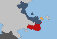
|image_map_caption = Labradoria in | |image_map_caption = Labradoria in 1810, indicated in red. | ||
|image_map2 = <!-- If second map is needed; does not appear by default --> | |image_map2 = <!-- If second map is needed; does not appear by default --> | ||
|image_map2_alt = | |image_map2_alt = | ||
Revision as of 11:59, 14 April 2021
The Federation of Labradoria | |
|---|---|
| 1769–1819 | |
|
Flag | |
 Labradoria in 1810, indicated in red. | |
| Capital | Eastminster Rhodeport |
| Common languages | Anglish and Variot |
| Demonym(s) | Labradorian |
| Government | Republic |
| Governor-General | |
• 1769-1782 | Henry Beaumont |
• 1801-1819 | Charles Landstadt |
| Legislature | Continental Assembly |
| House of Governors | |
| House of Delegates | |
| History | |
• Independence from Anglia | 1769 |
• Joined the 2nd Federation of Delamaria | 1 January 1819 |
| Currency | Labradorian Pound |
| Today part of | Delamaria |
| |
The Federation of Labradoria was a country located in Southern Delamaria from 1769 to 1819, when it formed the Federation of Delamaria with Lysian Columbia.
