User:Norcandy/Sandbox/Port Hope: Difference between revisions
mNo edit summary |
No edit summary |
||
| Line 1: | Line 1: | ||
{{Infobox settlement | {{Infobox settlement | ||
| name = Port Hope | | name = Port Hope | ||
| native_name = | | native_name = ''{{wpl|Afrikaans|Asteriaans}}: Port Hoop''<br>''{{wpl|Dutch language|Hennish}}: Hoopstad'' | ||
| native_name_lang = <!-- ISO 639-2 code e.g. "fr" for French. If more than one, use {{lang}} instead --> | | native_name_lang = <!-- ISO 639-2 code e.g. "fr" for French. If more than one, use {{lang}} instead --> | ||
| settlement_type = {{wpl| | | settlement_type = {{wpl|Capital city}} and {{wpl|Federal District}} | ||
| image_skyline = | | image_skyline = | ||
{{multiple image | {{multiple image | ||
| Line 25: | Line 25: | ||
| image_shield = [[File:Logo of the National Capital District.png|50px]] | | image_shield = [[File:Logo of the National Capital District.png|50px]] | ||
| shield_alt = | | shield_alt = | ||
| etymology = Named for [[Richard Hope| | | etymology = Named for [[Richard Hope|The Earl Hope of Longwood]] | ||
| nickname = Old | | nickname = Old Town; Sandy Cove | ||
| motto = ''Primum sibi ac Fidelissimum''<br>''{{wpl|English language|Estmerish}}: First and Most Loyal'' | | motto = ''Primum sibi ac Fidelissimum''<br>''{{wpl|English language|Estmerish}}: First and Most Loyal'' | ||
| image_map = National Capital District (NCD) in Satavia.png | | image_map = National Capital District (NCD) in Satavia.png | ||
| Line 79: | Line 79: | ||
| area_blank2_title = | | area_blank2_title = | ||
<!-- square kilometers --> | <!-- square kilometers --> | ||
| area_total_km2 = | | area_total_km2 = 336 | ||
| area_land_km2 = | | area_land_km2 = | ||
| area_water_km2 = | | area_water_km2 = | ||
| Line 113: | Line 113: | ||
| footnotes = | | footnotes = | ||
}} | }} | ||
'''Port Hope''' is the {{wpl|Capital city}} of [[Satavia]] and the [[Port Hope|National Capital District]], a federal territory within Satavia containing only the unitary authority of Port Hope. With a population of 2.4 million inhabitants, Port Hope is the most populous city in Satavia and also the oldest continually inhabited settlement on the island. Port Hope is located around [[Dolfynbaai]] and is situated at the mouth of the [[River Pelham]]. From the early 19th century the docks at [[Breybach Sands]] were some of the largest in the Asterias, before they slowly fell out of use as larger ships were unable to navigate the shallow waters at the mouth of Dolfynbaai, and by the late 20th century they had been made entirely redundant. | |||
Port Hope was founded as 'Nieuwe Zilverzee' on the 22 August, 1541 by the Hennish explorer [[Jan van Breybach]], who was the first Euclean to successfully navigate the [[Van Horn Straight]]. By 1590, the town had become known as 'Zanderig Inham', meaning 'Sandy Cove'. By 1747, Sandy Cove was by far the largest settlement on the island of Satavia and was the capital of the [[Dolfynbaai Kolonie]], the largest of the Satavian colonies. | |||
Revision as of 14:24, 19 July 2022
Port Hope
| |
|---|---|
Clockwise from top: Skyline from Hawke Mound; National War Museum; Breybach Sands Beach; Parliament Buildings; National Archives & Library; St John's Cathedral | |
| Etymology: Named for The Earl Hope of Longwood | |
| Nickname(s): Old Town; Sandy Cove | |
| Motto(s): Primum sibi ac Fidelissimum Estmerish: First and Most Loyal | |
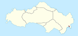
 National Capital District (NCD) in red | |
| Country | |
| Territory | National Capital District |
| Founded | 22 August, 1541 |
| Founded by | Jan van Breybach |
| Legislature | National Capital District Council |
| Government | |
| • Governor | Christopher Marshall |
| • Administrator | office vacant |
| • Mayor | Arthur Greenhouse (LIB) |
| Area | |
| • Total | 336 km2 (130 sq mi) |
| Population (2018) | |
| • Total | 2,421,671 |
| • Density | 7,200/km2 (19,000/sq mi) |
| Time zone | UTC+11 (Satavian Standard Time) |
| Post codes | 2 postcodes
|
| Website | ncd |
Port Hope is the Capital city of Satavia and the National Capital District, a federal territory within Satavia containing only the unitary authority of Port Hope. With a population of 2.4 million inhabitants, Port Hope is the most populous city in Satavia and also the oldest continually inhabited settlement on the island. Port Hope is located around Dolfynbaai and is situated at the mouth of the River Pelham. From the early 19th century the docks at Breybach Sands were some of the largest in the Asterias, before they slowly fell out of use as larger ships were unable to navigate the shallow waters at the mouth of Dolfynbaai, and by the late 20th century they had been made entirely redundant.
Port Hope was founded as 'Nieuwe Zilverzee' on the 22 August, 1541 by the Hennish explorer Jan van Breybach, who was the first Euclean to successfully navigate the Van Horn Straight. By 1590, the town had become known as 'Zanderig Inham', meaning 'Sandy Cove'. By 1747, Sandy Cove was by far the largest settlement on the island of Satavia and was the capital of the Dolfynbaai Kolonie, the largest of the Satavian colonies.


