Anirniq: Difference between revisions
m (AGAIN) |
m (Okay, should be all fixed, now just for more info) |
||
| Line 35: | Line 35: | ||
| population_footnotes = <br><small>Population consists of semi-permanent researchers and ecologists.</small> | | population_footnotes = <br><small>Population consists of semi-permanent researchers and ecologists.</small> | ||
| density_km2 = | | density_km2 = | ||
| languages = | | languages = | ||
| ethnic_groups = | | ethnic_groups = | ||
| timezone1 = | | timezone1 = | ||
Revision as of 21:04, 26 March 2023
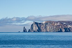
 The island as seen approaching from the east | |
| Geography | |
|---|---|
| Location | Winivere Bay |
| Area | 30.43 km2 (11.75 sq mi) |
| Length | 9.42 km (5.853 mi) |
| Width | 3.23 km (2.007 mi) |
| Highest elevation | 452 m (1,483 ft) |
| Highest point | Si'aati'shaa |
| Administration | |
| Demographics | |
| Population | 14 (2021) Population consists of semi-permanent researchers and ecologists. |
Anirniq (Template:IPAC-en) is an island in Winivere Bay and the only island territory held by Awasin. It is believed to have been discovered by Kaal'ga Jaad explorers in the ninth century and was inhabited by Ch'iyakem peoples from the tenth through the fourteenth centuries. Its name is a loanword from the [placeholder] language term of the same name, referring to the concept of 'living breath.' Though mapped in 1696, it was not officially recognized as Awasi territory until 1875.
Due to its location within the bay and distance from the mainland the island was the site of a permanently-manned military installation from 1881 to 1963. It was demilitarized by 1965 and converted to its present state as a nature reserve, though various corporations and private interests have attempted to lobby for mining and whaling rights. As of 2021 the sole settlement on the island is a government research station on the island's western cliffs.
History
Geography
Hydrography
Awasi government agencies have conducted hydrographic surveys of waters around Anirniq throughout the 20th century. These were conducted first by the Moh'toya'omakawakin in 1922 and its successor, the Awasi Hydrographic Institute, from 1968 on. Water depths near the island and to the south and east do not generally exceed 90 meters (295 ft), but become much greater to the west, and especially 45 kilometers (24 nautical miles) to the north, where the shelf of the bay slopes off into much deeper water.
The island lowland contains only two freshwater lakes covering about 4 square kilometers (1.5 sq mi) in all. Several streams flow into the ocean, with multiple waterfalls along the northwestern coast. The northern third of the island is home to multiple small glaciers.