Steel Road: Difference between revisions
(Created page with "{{Region_icon_Ajax}} {{Infobox rail line |name = Xellelbatan<br>ⵅⴻⵍⵍⴻⵍⴱⴰⵜⴰⵏ |image = Distriktstraße D1984 und Eisenbahnlinie bei Walvis Bay...") |
m (Char moved page Xellelbatan to Xallalbatan: Renamed) |
Revision as of 05:58, 8 October 2023
| Xellelbatan ⵅⴻⵍⵍⴻⵍⴱⴰⵜⴰⵏ | |
|---|---|
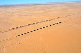
 A freight train on the Xellelbatan | |
| Overview | |
| Type | Combined freight and passenger line |
| Status | Operational |
| Locale | Charnea Ninva desert |
| Termini | Hamath (East terminus) Ekelhoc (West terminus) |
| Stations | 247 |
| Operation | |
| Character | At-grade |
| Technical | |
| Track length | 3,245 km |
| Track gauge | 1,500 mm (4 ft 11 in) |
The Xellelbatan (Tamashek: ⵅⴻⵍⵍⴻⵍⴱⴰⵜⴰⵏ, tr. "Backbone"), also known as the Ninvite Railroad, is a freight and passenger rail line which serves as the central axis of the transportation network in Charnea. It is comparable in its geographic extent to the West Scipian Railway while being entirely contained within one nation. The eastern and western termini of the Xellelbatan in the cities of Hamath and Ekelhoc respectively are approximately 1,300 kilometers apart, although the actual length of the railroad exceeds 3,200 kilometers traversing most of the Ninva as well as the Adjer and Arwa mountain ranges. The Xellelbatan serves to link up the small, densely inhabited productive regions of Charnea, each of which is centered on one of the six major cities of the country: Hamath, Perset, Azut, Tanitnet, Agnannet, and Ekelhoc (ordered from east to west). The line earns its name from its status as the backbone of the Charnean logistical web from which all spurs and international lines branch off, serving as the main logistical link through which goods and people flow between all six strategic regions of Charnea and the rest of the world.