Slovertia
The Sloveti republic (Sloveti: Slovertská Republika) Slovertia Sloveti:Slovertsko | |
|---|---|
| Motto: spolu ako jeden (Sloveti: Together as one) | |
| Capital | Brativas |
| Largest city | Kojbakvý |
| Official languages | Sloveti, Polish |
| Recognised national languages | Výhodný |
| Demonym(s) | Sloveti |
| Government | Federal Republic |
• President | Algá Brasní |
• Prime Minister | Rupert Wilmar |
| Legislature | National Assembly |
| Horná zostava | |
| Spoločné zhromaždenie | |
| Independence from Smertlonia, 1990 | |
• The Sloveti Declaration | 8th July 1990 |
| Population | |
• 2016 estimate | 7,490,678 |
• Density | 168.81/km2 (437.2/sq mi) |
| GDP (PPP) | 2018 estimate |
• Per capita | 23,442.71 USD |
| GDP (nominal) | 2018 estimate |
• Total | 105.9 billion USD |
| Gini (2016) | 25.9 low |
| Currency | Korúna (SKR) |
| Time zone | UTC +2 |
| Date format | dd-mm-yyyy |
| Driving side | left |
| Calling code | +423 |
Slovertia, Sloverti: Slovertsko, officially the Sloverti Republic (Slovak: Slovertská republika), is a landlocked country in Astyria. It is bordered by (Insert). Slovertias's territory spans about 43,000 square kilometres (16,000 sq mi) and is mostly mountainous. The population is over 7.4 million and consists mostly of ethnic Sloverti, the other two main groups are the Detsish and Výhodný people's. The capital is Brativas and the largest city is Kojbakvý. The official languages are Sloverti and German.
Etymology
The Sloveti name for Slovertia is Slovertsko is derived from the Czech word Sloverty other names for the country in German were Land der Flüsse meaning "Land of Rivers" and Slawisches Hochland The native name Slovertsko (1629) derives from an older name of Sloverts, Slové.The original meaning was geographic, since Slovertia did not form a separate administrative unit in this period.
History
Geography
Mountains
Slovertia is comprised of two main mountain ranges and three main rivers, The Tartara mountains
extend from the southern Detsish lsnds up into the capital Brativas where they then meet the rolling hills and uplands of the Lesser Frata region. The Tartara mountain range is represented as one of the three hills on the coat of arms of Slovertia. The highest peak in the country Slávu (2,877 m) is located in the north of the country eight miles outside of Brativas.
Caves
Under the mountains of Slovertia there are many caverns and caves. Twenty are open to thr puplic and seven are UNESCO world heritage sites they are; veľká jaskyňa, jaskyňa na severe, jaskyňa Kojbakny, východný priechod, brána do nížiny, priechod útechy and kráľovská jaskyňa.
Rivers
The three rivers of Slovertia; nížinná rieka, Had and stará rieka.
Nížinná rieka starts in the Tartara mountains where it flows down the the southwestern loslands for which it gets it name "The Passage to the Lowlands" It flows through the largest city in Slovertia, Kojbakvý. It flows for 360 km and is the longest river in Slovertia.
Had, given its name for it's shape winds down the Tartara mountains carving the hadí dolina or serpents valley. It id the shortest out of the three at 109 km.
Stará rieka means the old river, it runs through the Sloverti capital Brativas and then down into the south eastern hills before running bryond the Sloverti borders. Stará rieka runs for 220 km.
Climate
The Sloveti climate lies between the temperate and continental climate zones with relatively warm summers and cold, cloudy and wet winters. Temperature extremes are between −27 to 32.3 °C (−16.6 to 89.6 °F) although temperatures below −30 °C (−22 °F) are rare. The weather differs from the mountainous north to the plains in the south.
The warmest region is the south of the country and the region of south eastern Slovertia where the temperatures may reach 28 °C (82°F) in summer, occasionally up to heights of 37°C (99°F) in South Slovertia. The temperature in winter average in the range of −5 °C (23 °F) to 10 °C (50 °F). During night it may be freezing, but usually not below −10 °C (14 °F).
Politics
Slovertia is a parliamentary democratic republic with a multi-party system. The last parliamentary elections were held on 16th February 2019.
The Sloveti head of state and the formal head of the executive is the president (currently Algá Brasní, the first female president), though with very limited powers. The president is elected by direct, popular vote under the two-round system for a five-year term. Most executive power lies with the head of government, the prime minister (currently Rupert Wilmar), who is usually the leader of the winning party, but he or she needs to form a majority coalition in the national assembly. The prime minister is appointed by the president. The remainder of the cabinet is appointed by the president on the recommendation of the prime minister.
The nations highest legislative body is the unicameral national assembly (Spoločné zhromaždenie)which comprises of 190 seats. Assembly members are electrd on five year terms using the proportional representation system.
Foreign relations
The Ministry of Foreign Affairs (Sloveti: Ministerstvo zahraničných vecí) is responsible for maintaining the Sloveti Republic's external relations and the management of its international diplomatic missions. The ministry's director is Zuzana Obecny. The ministry oversees Slovertia's affairs with foreign entities, including relations with individual nations and its representation in international organizations.
Slovertia is a member of the United Nations (since 1991)
In 2020, Sloveti citizens had visa-free or visa-on-arrival access to 182 countries and territories, ranking the Sloveti passport 11th in the world.
Military
The Sloveti military currently has 20,000 active personnel. The main job of yhr Sloveti military is peacekeeping. The Ground forces are split into two main regiments; Airforce is made up of two main wings the Fighter wing and the Helicopter unit. While on thr ground the forces include the Repair battalion and the transport battalion as well as the Brativas city garrisson.
Administrative regions
Slovertia is split into 8 Kraj (meaning region) every region has s certain degree of autonomy. Obec are subdivided into many mestské regióny (meaning municipal regions) there are 82 mestské regióny.
In terms of economics and unemployment rate, the western regions are richer than eastern regions.
| Name in English | Name in Sloveti | Administrative seat | Population (2016) |
|---|---|---|---|
| Brativas Region | Brativlaský kraj | 1,100,000 | |
| Vrchovina Region | vrchovina kraj | 654,741 | |
| severska krajina Region | severská krajina kraj | 989,867 | |
| vychodna krajina Region | východná krajina kraj | 894,328 | |
| Kojbakvy Region | Kojbakvý kraj | 2,760,563 | |
| Stredna krajina Region | Stredná krajina kraj | 788,851 | |
| Ziemie północne Region | severné krajiny kraj | 791,723 | |
| uzna krajina Region | užná krajina kraj | Pueši |
514,678 |
Economy
The Sloveti economy is a developed, high-income economy,The country has difficulties addressing regional imbalances in wealth and employment as the west of the country is by far more well off than the east. GDP per capita ranges from extremely high averages in Brativas and Kjbakvý to averages of 59% of the Astyrian average in Eastern Slovertia.Although regional income inequality is high, 92% of citizens own their homes.
The Sloveti economy is one of the fastest-growing economies in Astyria In 2007, 2008 and 2010 (with GDP growth of 12.5%, 7% and 4%, retrospectively). In 2016, more than 89% of Sloveti exports went to it's Astyrian neighbours, and more than 50% of Sloverti imports came from other Astryian nations.
Unemployment, peaking at 22% at the end of 2003, decreased to 3,4% in 2019, lowest recorded rate in Sloveti history.
The Sloveti currency is the Sloverti Korúna (SKR) it currently exchanges at 30.17 to 1 euro.
Transportation
There are four main highways and four main expressways that run all across the country.
The D1 is the busiest road in Slovertia snd runs from the capital; Brativas to the largest city in Slovertia Kojbakvý. The D2 anc D3 highways run east to west of the country cutting through the northern highlands. while the D4 serves the south of the country.
Slovertia has four main international airports; Brativas, Kojbakvý, Žiprata and Pueši. Brativas and Kojbakvý both have city airports about three miles from their centres.
The Sloveti Republic Rail Service runs all train services in Slovertia.
The country's largest port in thr country is located in Brativas along the Stará rieka which runs through thr city.
Tourism
Slovertia features natural landscapes, mountains, caves, medieval castles and towns, folk architecture, spas and ski resorts. More than 7,4 million tourists visited Slovakia in 2016, and the most attractive destinations are the capital of Brativas, The city of Kojbakvý and the High Tartaras. Most visitors come from the surrounding Astyrian nations (about 33%).
Demographics
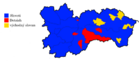
The population is over 7.4 million and consists mostly of Sloveti people. The average population density is inhabitants per km². The 2016 census states that the majority of the inhabitants of Slovertia are Sloverti (72.9%). Poles the largest ethnic minority (18.5%). Other ethnic groups include Výhodný (6%), Nikolian (2%) and others and unspecified (0.6%).
The three main ethnic groups are symbolised by the three stars on the Sloveti flag abd coat of arms.
Language
The main language of Slovertia is Sloveti, a member of the Slavic language family. Polish is widely spoken in the northern regions, and Výhodný which is a language similar to Czech and is used in some parts of the northeast. Minority languages hold co-official status in the municipalities in which the size of the minority population meets the legal threshold of 10%. In 2001 Polish was made an official language after the Polish speaking community doubled in size from 5% of the population to 10%. In 2016 it had risen to 18.5% in 2016.


