Mehrava
Militarized State of Mehrava Mizardâd Shâqdarâv Mehravâ | |
|---|---|
| Motto: 'Guriyanfâr Mehravâ!' | |
| Anthem: "Humarz Muztananûv" Hums of the Mountains | |
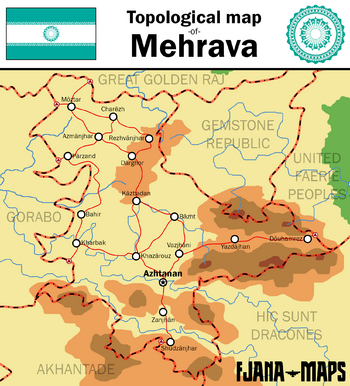
 Geographical map of Mehrava, including major cities and roads. | |
| Capital | Azhtanan |
| Largest city | Môztar |
| Official languages | Mehrani |
| Recognised regional languages | Arabic |
| Ethnic groups | 95.8% Mehrani 4.2% Arab |
| Demonym(s) | Mehravan |
| Government | Military junta |
• Supreme Leader | Arzhan Admejhad |
| Establishment | |
• Supreme Council for National Reconstruction of Mehrava | 1985 |
• Militarization | 1990 |
| Area | |
• Total | 1,313,351 km2 (507,088 sq mi) |
| Population | |
• 2020 estimate | 83,987,229 |
• 2019 census | 83,183,741 |
| GDP (nominal) | 2019 estimate |
• Total | 917.000 billion $ACU |
• Per capita | 11,012 $ACU |
| HDI (2019) | 0.813 very high |
| Currency | Mehraz (MMR) |
| Time zone | UTC-2 (UTC) |
| Date format | DD/MM/YYYY |
| Driving side | left |
| Calling code | +84 |
| Internet TLD | .mrv |
Mehrava, officially known as The Militarized State of Mehrava, is a medium-large sized country on the western area of Thrismari, bordering Gemstone Republic & United Fairie Peoples to the east, and Gorabo to the west, Mehrava is a landlocked country with an area of 1,313,351 square kilometres (507,087 sq mi), with a decently intrustrialized economy especially its oil & gas industry which generates 65% of the country's GDP. It also has vast mineral resources.
The territory of Mehrava has historically been inhabited by nomadic groups and empires. In antiquity, the nomadic tribes inhabited the northern steppes and the mountainous tribes settled in the mountain ranges in the southeast all of which would be conquered by the Goraboese Caliphate from the west later on.

