Imarios
Commonwealth of Imarios Imarione: Tosolmithi ar Imariio | |
|---|---|
|
Flag | |
| Motto: Despite ashes covering the skies, Imarios never stops. Imarione: Kali ż sutte kov mhhl mistht, Imariio iĵé cese. | |
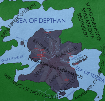
 A political map of Imarios | |
| Capital | Expesia pop. (2,220,101)[1] |
| Largest city | Lyyra pop. (7,551,330)[1] |
| Official languages | Imarione, English |
| Recognised regional languages | Ghad, Masmari dialect |
| Ethnic groups | Imarione (84%)[1] Ghad (11%)[1] Other (5%)[1] |
| Religion | No official, local religions recognized |
| Demonym(s) | Imarione |
| Government | Commonwealth |
• President | Sarche Delvoun |
| Formation | |
| 900 BCE[2] | |
• Expesia founded, Duchy of Imarios founded | 629 CE[2] |
• First Republic of Imarios | 1161 CE[2] |
• Commonwealth of Imarios founded | 1792 CE |
| Population | |
• 2015 census | 89,740,440[1] |
| Currency | Chaut (₵) (ICH) |
| Date format | yyyy-mm-dd |
| Driving side | right |
| Calling code | +894 |
| ISO 3166 code | IMR |
| Internet TLD | .imr |
- This article is undergoing a major update.
Imarios (Imariio), officially the Commonwealth of Imarios (Tosolmithi ar Imariio), is a sovereign nation in Anteria, on the continent Atracia. It is predominantly inhabited by its native Imarione people. Agriculture makes up a majority of Imarios' economy, in fact four out of Imarios' seven provinces are dominated by the agriculture industry. The capital of the nation, Expesia, sits on the banks of the Expes River in a special administrative district made up of the city and its southern counterpart. The Greater Expesian Metropolitan Region is home to over ten million people, over two million alone in Expesia itself. On the opposite side of the nation is the most populous city, Lyyra, with nearly seven and a half million people living in it. Lyyra is located on the banks of the Sea of Teteria, a large inland saltwater sea in which the volcanic island chain that makes up the province of Teteria is located. Imarios' national language is Imarione, which is also the nation's demonym.
Imarios has no national religion, but recognized local religions, especially in the rural parts of Ghaderi and Defanni. Imarios' history dates back nearly three millennia, back to the formation of the Ci'dune duchies on the Teterian archipelago. Nearly fifteen hundred years later, Expesia was founded alongside the first Duchy of Imarios by Teterian explorers. Back in that time, a river once connected the port of Sens through to the Bay of Defanni, but soon after the formation of the duchy, the river's path was diverted by a series of long rains in the region, which resulted in mudslides and avalanches. As such, the Teterian explorers remained in the Expes river area for many years. 1200 years later, the current Commonwealth was founded.
Geography
Imarios is located in a central portion of the continent Atracia on Anteria, but despite its position it has access to the ocean via a series of straits owned by a neighboring nation, the Serene Republic of Nerany. The Kingdom of Vallica is also located across water to Imarios' north. By land, Imarios borders the Democratic Republic of Degunhe to its southwest, and the Republic of Franc-castel to the northeast. To the east is the Sea of Teteria, a saltwater "sea" landlocked but containing the volcanic Teterian island chain. Imarios is made up of eight provinces and one special administrative district—Depthan and Bahthran on the northern coast, Defanni in the southwest, Ghaderi inland along the Imarione Mountains, Bastur to the south, Masmar centrally located, Teteria in the sea of the same name, and the Expesia district located in Defanni.
Imarios' terrain is dominated by flat plains and rivers, with a long mountain range extending through the center of the country. Four of the seven provinces were dominated by the agricultural industry, those being Defanni, Ghaderi, Bastur and Masmar. Teteria's terrain is unsuitable for large-scale farming due to the volcanic mountains that make up the islands, and Depthan is primarily marshlands and forests, along with Bahthran. A majority of Imarios' population either lives in the plains of the Expes River, or in and around Lyyra and Ekton. To Imarios' extreme south is the vast Bastur River delta, a region of inhospitable marshland mostly uninhabited by Imariones. However, it is inhabited by native tribal peoples and a variety of rare species.
History
Prehistory
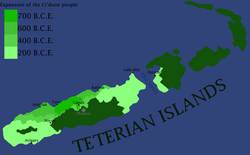
Reliable records can only be dated back as far as 200 BCE, but before then, artifact dating traces the origins of modern-day Imariones to the Ci'dune (before-men in English) of the Teterian archipelago. The city of Teter, despite its name existing in records as far back as 150 BCE,[2] was believed to have undergone several different stages of existence. The furthest back ruins are located approximately fifteen kilometers out from the modern-day town of Ganan,[3] at the foot of the mountain Phanssi. These ruins are dated back to around 800 BCE, which means that settlers arrived at the location at around that time. It is unknown where these settlers arrived from, as their geneology only connects them to minorities in other nations on the continent.
Over the following 600 years, the Ci'dune people expanded steadily, but by the year reliable records could be dated back to, there was no evidence that the Ci'dune people had colonized the entirety of Great Teter Island. Towns located on the southern side of Phanssi could only be dated back to 90 CE, however it is known that Phanssi erupted earlier than that. The early Ci'dune people had very spiritual beliefs about nature, and regarded Phanssi as a manifestation of a god. Shrines were built at the town of Ganan, dating back to 300 BCE, which depicted a human male with a volcano on his head.
Early history
A majority of written records originates from the Sens record hall, an ancient library of sorts which was believed to have finished construction around 200 BCE. The hall stands to this day, and has a reliable list of the kings of Ci'dune. The record hall also describes a war with "a people from the northern lands" in which individuals originating from the forests to Imarios' north burned down the town of Lyyra, then sent a boat of three children towards the Ci'dune fleet to recount the story. The identity of these people is currently unknown, as there is no other known mention of them.

