Chilokver
This article is incomplete because it is pending further input from participants, or it is a work-in-progress by one author. Please comment on this article's talk page to share your input, comments and questions. Note: To contribute to this article, you may need to seek help from the author(s) of this page. |
Republic of Chilokver | |
|---|---|
|
Flag | |
| Motto: E Pluribus Unum (Arlesian) "Out of many, one" | |
| Anthem: "We are Chilokveri" | |
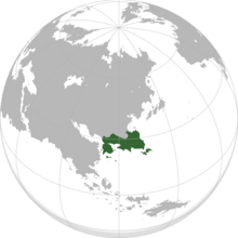
 Area controlled by Chilokver shown in green; claimed but uncontrolled regions shown in light green | |
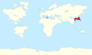
 Area controlled by Chilokver, including dependent territories, shown in red | |
| Capital | Apelia |
| Largest city | Jiafen |
| Official languages | Standard Chilokveri · Cambrian |
| Demonym(s) | Chilokveri |
| Government | |
| Ada Luong | |
| TBA | |
| TBA | |
| TBA | |
| TBA | |
| Legislature | National Assembly |
| Council of States | |
| Congress of Deputies | |
| Independence from | |
• Chaeyoungi Empire | 1839 |
• Yaoist regime falls | 1965 |
• Ratification of constitution | 1986 |
| Area | |
• Total | 1,829,030 km2 (706,190 sq mi) |
| Population | |
• 2021 estimate | 196,827,398 |
• 2019 census | 195,262,176 |
• Density | 107.61/km2 (278.7/sq mi) |
| GDP (PPP) | 2018 estimate |
• Total | $8.15 trillion |
• Per capita | $41,737 |
| GDP (nominal) | 2018 estimate |
• Total | $8.77 trillion |
• Per capita | $44,909 |
| Gini (2018 (est.)) | 34.0 medium |
| HDI | very high |
| Currency | Chilokveri credit (₡) (CLC) |
| Time zone | UTC+8 to +10 |
| Date format | dd/mm/yyyy |
| Driving side | left |
| Calling code | +648 |
| ISO 3166 code | CL |
| Internet TLD | .cl |
Chilokver (Chilokveri: Tīngwok), officially the Republic of Chilokver (ROC; Chilokveri: Tīnhahmàhn Guhngwòhgwok), is a sovereign state primarily located in East Serica, consisting of 14 districts and 1 overseas domain. With a total area of approximately 1.83 million square kilometres (~706,000 square miles), Chilokver is the 3rd largest nation on Serica and the 15th-largest country overall on Atlas. The nation borders Acronia through the territory of Juk Long at the south-eastern extreme of continental Chilokver and shares a maritime border across the Zheng Mou Sea with Saegya to the south-west. Through its overseas domain of Alairia, it also shares a maritime border with Ahras.
Name
The name Chilokver originates from the 14th century Kinlander explorer Markus Gilverad, who was the first Vesperian to travel along the Golden Belt and extensively document his journey. In his travels, he explored as far east as modern day Jungyeh and came into contact with the Jilohk people of southern Chilokver; at the time a rough collection of coastal fishing tribes which had escaped incorporation into the contemporary ruling Yuan dynasty. Due to a case of inaccurate conversion between Chilokveri li and miles, Gilverad mistakenly believed that the opening of the Zheng Mou Sea was far wider than it was in actuality and that it cut off the Jungyeh peninsula from continental Serica. He termed this new landmass Jilohkver by attaching the Kinnish suffix -ver, meaning place of or fishing centre, to the name of the native Jilohk people. The term was later appropriated by 16th century Acronian cartographers to refer to the greater Liang dynasty nationstate which had by then assimilated the Jilohk into their empire, and transformed over time into the more familiar Chilokver.
The common sinitic name Tīngwok or "heavenly nation" is derived from the cultural concept of Tīnhah. Under the ideological worldview of Sinocentrism, Tīnhah (lit. "all under heaven") denoted all lands and geographical spaces divinely appointed to the Emperor of Chilokver through the Mandate of Heaven; hence the term Tīnjīu ("Celestial Empire") to refer to Chilokver. While the traditional Tīnhah concept collapsed in the 19th century with the decline of the Chaeyoungi Empire, the phrase Tīnjīu remained in use through the 20th century in its nationalistic variant Tīngwok. After the 1985 Constitution was enacted, Tīngwok was also adopted as the abbreviation for Tīnhhahmàhn Guhngwòhgwok.
In Cambrian, Chilokver is pronounced as /tʃilɒxvɜːr/ CHEE-lokh-vur or /tʃɛlɒxvɜːr/ CHEH-lokh-vur, with the Clarendon Cambrian Dictionary listing the former pronunciation. The pronunciation /tʃaɪlɒxvɜːr/ CHY-lokh-vur can be heard among Temischois Cambrian speakers. In Acronian, Chilokver is known as Chiloque ([ʃilɔk]) with the corresponding demonym being Chiloquois ([ʃilɔkwa]).
As promulgated in the national constitution, the official name of the state is the Republic of Chilokver (Tīnhhahmàhn Guhngwòhgwok).
History
Prehistory
Politics
Government
Foreign relations
Military
Administrative divisions
Districts

| District | Capital | Area (sq km) |
Population (2014 census) |
Density (per km2) |
GDP (CL₡) |
GDP per capita (CL₡) |
|---|---|---|---|---|---|---|
| Gipguk | TBA | TBA | TBA | TBA bn | TBA | |
| Linglaai | TBA | TBA | TBA | TBA bn | TBA | |
| Jungyeh | TBA | TBA | TBA | TBA bn | TBA | |
| Mukhak | TBA | TBA | TBA | TBA bn | TBA | |
| Ngahnjoh | TBA | TBA | TBA | TBA bn | TBA | |
| Seuhngyeh | TBA | TBA | TBA | TBA bn | TBA | |
| Fungjau | TBA | TBA | TBA | TBA bn | TBA | |
| Luhkbunmuhk | TBA | TBA | TBA | TBA bn | TBA | |
| Dungyeuhng | TBA | TBA | TBA | TBA bn | TBA | |
| Seichyunguk | TBA | TBA | TBA | TBA bn | TBA | |
| Gotsai | TBA | TBA | TBA | TBA bn | TBA | |
| Yahtbeiguk | TBA | TBA | TBA | TBA bn | TBA | |
| Gammihktihng | TBA | TBA | TBA | TBA bn | TBA | |
| Sahnbou | TBA | TBA | TBA | TBA bn | TBA | |
| Dihkwa | TBA | TBA | TBA | TBA bn | TBA | |
| Douhtihn | TBA | TBA | TBA | TBA bn | TBA | |
| Jukdeih | TBA | TBA | TBA | TBA bn | TBA | |
| Muhkcheuhng | TBA | TBA | TBA | TBA bn | TBA | |
| Wohngji | TBA | TBA | TBA | TBA bn | TBA | |
| Gwongmeih | TBA | TBA | TBA | TBA bn | TBA | |
| Sahntihn | TBA | TBA | TBA | TBA bn | TBA | |
| Hahngdak | TBA | TBA | TBA | TBA bn | TBA | |
| Miuhdin | TBA | TBA | TBA | TBA bn | TBA | |
| Pihngwotoih | TBA | TBA | TBA | TBA bn | TBA | |
| Saamleuhn | TBA | TBA | TBA | TBA bn | TBA | |
| Chinchyun | TBA | TBA | TBA | TBA bn | TBA | |
| Naahmfong | TBA | TBA | TBA | TBA bn | TBA | |
| Tongdou | TBA | TBA | TBA | TBA bn | TBA | |
| Yahpguk | TBA | TBA | TBA | TBA bn | TBA | |
| Sahnjih | TBA | TBA | TBA | TBA bn | TBA | |
| Chintohmuhk | TBA | TBA | TBA | TBA bn | TBA | |
| Ganjeun | TBA | TBA | TBA | TBA bn | TBA | |
| Lohkhahp | TBA | TBA | TBA | TBA bn | TBA | |
| Jimauh | TBA | TBA | TBA | TBA bn | TBA |
Geography
Location
Flora and fauna
Economy
Demographics
Religion
Culture
Cuisine
Sport
Music
See also
- History of Chilokver
- Politics of Chilokver
- Districts of Chilokver
- Foreign relations of Chilokver
- Chilokveri Armed Forces
- Law of Chilokver
- Judiciary of Chilokver
- Geography of Chilokver
- Climate of Chilokver
- Environment of Chilokver
- Wildlife of Chilokver
- Economy of Chilokver
- Transport in Chilokver
- Energy in Chilokver
- Science and technology in Chilokver
- Demographics of Chilokver
- Languages of Chilokver
- Religion in Chilokver
- Education in Chilokver
- Health in Chilokver
- Culture of Chilokver
- Chilokveri cuisine
- Chilokveri literature
- Music of Chilokver
- Sport in Chilokver
- Public holidays in Chilokver
- Media of Chilokver
- Chilokveri philosophy
- Cinema of Chilokver
