Acronia
This article is incomplete because it is pending further input from participants, or it is a work-in-progress by one author. Please comment on this article's talk page to share your input, comments and questions. Note: To contribute to this article, you may need to seek help from the author(s) of this page. |
Union of Acronian Kingdoms Union de Royaumes Acroniens | |
|---|---|
 Flag
 Coat of arms
| |
| Motto: Nemo Me Impune Lacessit (Latin: No one provokes me with impunity) | |
| Anthem: Forefathers of Victory | |
| Location in Atlas Location in Atlas | |
| Capital | Lionsgate |
| Largest city | Defense |
| Official languages | French · English |
| Recognised regional languages | Cantonese • Dauphinois • Japanese • Occitan • Surin |
| Ethnic groups (2015) | 68.7% White 10.1% Asian 9.2% Black 5.3% Mixed 6.7% Other |
| Demonym(s) | Acronian |
| Government | Unitary parliamentary constitutional monarchy |
• King | Francis III a |
• President | Jules Patry |
• Vice President | Angus Duckworth |
• Leader of the National Assembly | Didier Lazare |
• Head of External Affairs | Leonard Elliott |
• Head of Parliament | Bernard Cossney |
• Head of Justice | Eden Santa Cruz |
| Legislature | National Assembly |
| Parliament | |
| Chamber of Representatives | |
| Establishment | |
• Grand Acronia | 25 November 6 CE |
• Grand Acronian Empire | 24 January 920 |
• Kingdom of Acronia | 15 April 1696 |
• Union of Acronian Kingdoms | 23 June 1904 |
| Area | |
• Total | 1,057,408 km2 (408,268 sq mi) |
| Population | |
• 2016 census | 208,525,213 |
• Density | 197.2/km2 (510.7/sq mi) |
| GDP (nominal) | 2014 estimate |
• Total | $9.6 trillion |
• Per capita | $46,038 |
| HDI | 0.959 very high |
| Currency | Acronian Franc (AFR) |
| Calling code | +42 |
| |
The Union of Acronian Kingdoms, commonly known as Acronia, the Acronian Union, the AU, the UAK, or the AK, is a unitary parliamentary republic and presidential constitutional monarchy in Atlas. Comprising 20 provinces further organized into 90 departments, mainland Acronia is situated on the Elysian subcontinent at the westernmost point of contiguous Vesperia, with its immediate island holdings jutting out westward from the Acronian Sea into the Fale Ocean. The Union also consists of 3 autonomous districts: Astonbury; Juk Long; and Valdiu, as well as the Acronian Far-East Territories, bringing the Union to a total of 21 provinces and 99 departments. The nation shares land borders with the Osotia to the northeast, Saizy to the east, Odentia and the Lyonine Empire to the southeast, as well as Chilokver via Juk Long. The nation is flanked by the Acronian Sea and the Fale Ocean to the west, the Carnegie Sea to the south, and the Mistral Sea to the north. Encompassing roughly 1.05 million square kilometers (approximately 650 million square miles) populated by 208.5 million people, Acronia occupies 5 time zones, possesses land on 3 continents, and is the 11th largest nation by area in Atlas. Possessing a diverse climate ranging from subtropical to tundra, Acronia is a highly mountainous country, with 70% of its territory above 1,000 meters above sea level. The Acronian Union's highest point is Aegran Ridge, which stands at an altitude of 6,828 meters.
History
Prehistory
Era of Warring States (139 BCE–6 CE)
Period of Ten Kings (139 BCE–33 BCE)
Aegran-Montfortian Wars (33 BCE–6 CE)
Grand Acronia (6 CE–946)
Saxone conquests (42 CE–50 CE)
Vikingr Invasion (894–900)
Grand Acronian Empire (920–1696)
Bellicosum (1545–1696)
Acronian Wars of Piracy (1549-1665)
Colonial expansion (1552–1696)
War of Three Queens (1667–1671)
Acronian Civil War (1682–1692)
Separated Acronia (1692–1696)
Contemporary Acronia (1903–present)
First Great War (1903–1911)
Blue Rebellion (1903–1904)
War at large (1904–1911)
Interwar period (1911–1938)
Second Great War (1938–1946)
Parabellum (1946–1988)
Surin War (1968-1975)
Modern period (1988–present)
Geography
The Free Union of Acronius's territory includes a group of four islands known as the Acronian Overseas Territories (also referred to as 'mini-Acronius by many Acronians) off the coast of the Neo Philippine Empire, as well as land in northwestern Strøltenheim (also referred to as 'the mainland' by many Acronians') separated into thirty different provinces. The mainland is split in half by the Anneau River, which historically served as both the border between the First Republic of Acronius and the Chancellory of Acronius, and continues to separate the two up to this day as an ethnolinguistic border between the Francophones and Anglophones in Acronius, and disgorges into the Fale Ocean.
Two principally mountainous regions exist within the Free Union. The Khionan Mountains dominate the northeastern area of the nation, with its culminant point of elevation being Aegran Ridge, which stands at 5,986 meters. Several major cities, namely Aiguebelle, Arleaux, Azemont, and Vaumont, are situated within the mountain range. The Flaxen Mountains are situated in the west of the nation, along the border with Adampia, and is one of the most mineral-rich areas on the continent, with minerals such as gold and emerald abundant and extracted from several mines owned and operated by various corporate entities. The Great Northwestern Tundra covers a large amount of the centre of Acronius, with Lake Bruxelles and Dead Sands covering most of the Free Union's eastern coastline. Forests and grasslands make up the remaining southeast areas of the nation.
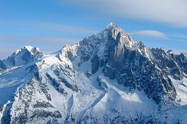
Mont Grivois, a popular skiing destination amongst tourists in the Khionan Mountains.

Lake Bruxelles, in the province of Loraux.

Olive orchards in Vevai Island Territory.

The Anneau River along the border between the provinces of Crosswood and Royal Banks.


.jpg)
Administrative divisions

Environment
Politics
Government
Law
Foreign Relations
Military
Equipment of the Acronian Military Forces 1st Special Operations Group 5th Special Operations Group
Sciences
Demographics
Ethnic groups
Major cities
The Free Union is a highly urbanized country, with its largest cities (in terms of metropolitan area population) in 2011 being Defense (25,850,073 inh.), Lionsgate (13,234,442), Aberdeen (11,171,442), Delancey (9,034,812), Scunthorpe (8,878,239), Olloix (8,634,812), Arleaux (8,007,652), Juilly (7,553,320), and Royston (6,788,239). Acronius also participates in the governance of it's highly autonomous city state, Astonbury, which is listed just ahead of Delancey in population, surpassing the 9.1 million mark. (Note: There are significant differences between the metropolitan population figures just cited and those in the following table, which only include the core population). Rural flight was a perennial political issue throughout most of the 20th century.
Largest cities or towns in Acronia
2014 census | |||||||||
|---|---|---|---|---|---|---|---|---|---|
| Rank | Region | Pop. | Rank | Region | Pop. | ||||
 Defense  Lionsgate |
1 | Defense | Montfort | 25,850,073 | 11 | Wressleville | Eden | 6,583,459 | Redbanks Redbanks Astonbury Astonbury |
| 2 | Lionsgate | Sheridan Island | 13,234,442 | 12 | Copper Bluff | Aegrus | 5,822,322 | ||
| 3 | Redbanks | Grand Coast | 11,171,442 | 13 | Kingsmouth | Maitland | 5,332,654 | ||
| 4 | Astonbury | Astonbury | 9,105,156 | 14 | Juk Long | Juk Long AAD | 5,099,343 | ||
| 5 | Delancey | Grand Coast | 9,034,812 | 15 | Vallandry | Bruges | 4,883,662 | ||
| 6 | Fyrestone | Pandora | 8,878,239 | 16 | Indiewood | Highlands | 4,563,612 | ||
| 7 | Olloix | Mistralie | 8,634,812 | 17 | Olympus | Prospect Islands | 4,268,976 | ||
| 8 | Sierre | Ithaque | 8,007,652 | 18 | Montecristo | Polverouse | 3,899,987 | ||
| 9 | Thégra | Cenis | 7,553,320 | 19 | Ravensmere | Aegrus | 3,603,291 | ||
| 10 | Alexandria Bay | Sheridan Island | 6,788,239 | 20 | Vaumont | Toussaint | 2,745,915 | ||
Language
Religion
Acronius has a mainly atheist and agnostic population. According to a survey in January 2015, only 20.4% of the population described themselves as a person of faith, while only 17.3% of the population affiliated themselves with a specific religion (with the remaining 3.1% of the population identifying as deists), making the Free Union one of the most atheist nations in the region of Atlas. The most predominant religions are: Church of Acronius (8.1%), Christianity (3.2%), Judaism (1.9%), and Islam (1.2%). The First and Fourth Amendments of the Golden Edict guarantee religious freedom, and prevents legislation favoring any religion over another. In addition, discrimination based on religion is illegal, with the sole exception of hate speech.
