Mygona
United Kingdom of Mygona Reno Unid di Mygona | |
|---|---|
|
Flag | |
 Mygona Location in Southwestern Olivacia | |
| Capital and largest city | Almaju |
| Official languages | Mygonese |
| Ethnic groups | 94% Mygonese 6% Others Groups Sub-groups in Mygona Almajuan 43% Zragatian-Arreminian 29% Sakatarian 22% Wassilian 4% Other International 2% |
| Government | Parlamentiary Monarchy |
• Monarch | Queen Ectarine IV of Mygona |
• Prime Minister | Tole Frimingham |
| Legislature | The Royal Parlament of Almaju |
| Kaza Rial | |
| Kaza di Cumunos | |
| Area | |
• Total | 771.029 km2 (297.696 sq mi) |
| Population | |
• 2020 estimate | 52.894.334 |
• Density | 68.6/km2 (177.7/sq mi) |
| GDP (nominal) | 2020 estimate |
• Total | $1.865 trillion |
• Per capita | $31,666 |
| HDI (2021) | 0.853 very high |
| Currency | Mygon M$ |
| Time zone | UTC +4, UTC +5 |
| Date format | dd.mm.yyyy |
| Driving side | right |
| Calling code | +665 |
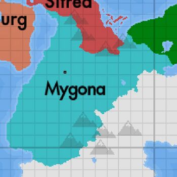
The United Kingdom of Mygona, The Kingdom of Mygona or just Mygona is located in the southwest of the continent of Olivacia in the world of Anteria having its coast to the Sunadic Ocean.
National Overview
The United Kingdom of Mygona is a medium-sized nation located on a peninsula in southwest Olivacia bordering 2 nations Sitrea in the north, which country has a border divided by the Mountains of Kalzagos and Cascadia to the northeast, this almost border being entirely flat. To the west it has the longest of its 3 coastlines, having coast to the Sunadic Ocean (Gopk Sea), Kecost Strait and Figtízia Sea and to the east it has coast to the Gulf of Yulua and Sunadic Ocean again. In the center of the country there is an immense forested area naturally named the Vin Forest and in the southeast there is an immense mountain range of Tanuz. Most of the country has a temperate climate but on the coast of the provinces of Bendegolia and Kecost the climate is Mediterranean, these are the provinces with the warmest climate while the provinces of Heldengol and Gadonia are colder thanks to the Tanuz Mountains. The capital Almaju is inland and is bathed by the Almaju River and the port city of Yonuw is located at the mouth of this same river on the shores of the Sea of Figtízia. Other major towns in Mygona are Port Quahin, a major seaside town on the coast of the Sunadic Ocean, Arrem a financial center on the banks of Mygona's largest river, the Arrem River and Calamana another industrial center on the Arrem River Basin. The mygonese government is a parliamentary monarchy, the head of state is Queen Ectarine IV, 48 years old while the head of government is Prime Minister Tole Frimingham, elected in 2020 for a 4-year term and may run again in 2024 and so will he is leader of the centre-right Liberalis Mygona party and he also serves as head of the Royal Parliament of Almaju. Mygona is subdivided into 16 provinces, 2 of which are provincial cities Almaju and Yonuw, each having its capital for administrative purposes and its subdivisions are separated into communes and these also have host cities.
History
The first mygonese peoples probably arose in 2000 BC in the region of the Aberena River Valley in Yulua. Little is known about how these peoples fed, dressed, their beliefs and how they dealt with the land. The mygonese for many centuries were separate peoples in city-states, kingdoms, principalities, duchies and even empires but they always kept in touch due to linguistic proximity, they traded in products that they did not own, such as oranges produced in Bendegolia that reached the city of Mihr or the rice coming from Figtízia was consumed in Sakatara. But there were 3 main political controls, the Kingdom of Almaju, the Warlenhi Empire and the Duchy of Yulua. The most powerful and influential of the mygonese peoples was the Kingdom of Almaju, which had its power centralized in 2 large cities: Almaju and Yonuw, both grew and prospered thanks to the cultivation of varied vegetables and wheat, Yonuw still had fishing and a privileged location. driving its growth. The Warlenhi Empire had its capital, Sakatara, as its center of power, a city named after the river that bathes it and came from a growing territorial expansion. And the Duchy of Yulua had as its center of power the capital of the same name, the port city of Yulua.
17th century in Mygona
During the second half of the 17th century, the expansionism of the Warlenhi Empire caused it to declare war against the Duchy of Yulua in search of an outlet to the ocean. This conflict lasted longer than expected by the authorities of Warlenhi causing the emperor of the time, Corgan III, to ask the king of Almaju, Ectario X, to mediate the conflict in search of peace in the region. The king accepted the request and mediated the conflict that finally saw a union between the three monarchies. The treaty was signed with the following agreement, the Crown Prince of Almaju would marry one of the daughters of Emperor Corgan III uniting the Warlenhi Empire and the Kingdom of Almaju and the Duchy of Yulua would enter into the union as a semi-autonomous state, answering to crown but still having the Duke of Yulua as a leader.
