Thaidaeng
Jump to navigation
Jump to search
People's Democratic Socialist Republic of Thai Daeng สาธารณรัฐสังคมนิยมประชาธิปไตยประชาชนไทยแดง (Thai) Satharonrat Sangkhomniyamo Prachathipatai Prachachon Thai Daeng | |
|---|---|
| Anthem: | |
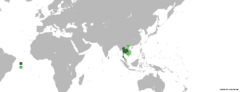
 Dark green is the area controlled by Thai Daeng and light green the area claimed but uncontrolled | |
| Capital and largest city | Khwāmotnithotnomkan |
| Official languages | Thai |
| Religion (2566 BE) | 88.7% Buddhism (official) 6.6% Animism and folk religions 3.3% No religion and unaffiliated 1.2% Christianity 0.2% Islam |
| Demonym(s) | Thai |
| Government | Unitary marxist-leninist one-party socialist republic |
| Currency | Baht |
| Climate data for insert location | |||||||||||||
|---|---|---|---|---|---|---|---|---|---|---|---|---|---|
| Month | Jan | Feb | Mar | Apr | May | Jun | Jul | Aug | Sep | Oct | Nov | Dec | Year |
| Average high °C (°F) | 33.0 (91.4) |
34.6 (94.3) |
37.4 (99.3) |
41.6 (106.9) |
43.3 (109.9) |
45.2 (113.4) |
44.7 (112.5) |
44.5 (112.1) |
40.3 (104.5) |
38.8 (101.8) |
38.5 (101.3) |
35.0 (95.0) |
39.7 (103.5) |
| Daily mean °C (°F) | 30.3 (86.5) |
31.5 (88.7) |
33.1 (91.6) |
35.3 (95.5) |
36.2 (97.2) |
37.3 (99.1) |
36.9 (98.4) |
36.7 (98.1) |
34.4 (93.9) |
33.6 (92.5) |
33.5 (92.3) |
31.7 (89.1) |
34.2 (93.6) |
| Average low °C (°F) | 27.6 (81.7) |
28.5 (83.3) |
28.9 (84.0) |
29.1 (84.4) |
29.1 (84.4) |
29.5 (85.1) |
29.1 (84.4) |
29.0 (84.2) |
28.6 (83.5) |
28.5 (83.3) |
28.5 (83.3) |
28.4 (83.1) |
28.7 (83.7) |
| Average precipitation mm (inches) | 964 (38.0) |
953 (37.5) |
730 (28.7) |
447 (17.6) |
22 (0.9) |
15 (0.6) |
31 (1.2) |
71 (2.8) |
467 (18.4) |
499 (19.6) |
852 (33.5) |
806 (31.7) |
5,857 (230.5) |
| Source: [NAME OF THE WEBSITE] | |||||||||||||
