Josephinia
This article is incomplete because it is pending further input from participants, or it is a work-in-progress by one author. Please comment on this article's talk page to share your input, comments and questions. Note: To contribute to this article, you may need to seek help from the author(s) of this page. |
Commonwealth of Josephinia 𐒿𐓂͘𐓄𐒰 𐓀𐒰͘𐓓𐒰͘ 𐓁𐒻 𐓓𐓎𐓊𐒷 Sopʼa Mąžą Ni Žucʼe (Ínts’o) | |
|---|---|
| Motto: Ex Unitate Vires (Hernician) "Unity is Strength" | |
| Anthem: "Land of Old and Plenty"
| |
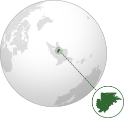
 Location of Josephinia in Elia Borealis (dark green) | |
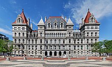
| Capital | Haliburt |
| Largest city | Port Royal |
| Official languages | Fallish |
| Recognised regional languages | Ínts’o Polhetan |
| Ethnic groups | 54.6% Native 28.5% White 9.1% Mixed 2.0% Yinese 5.8% others |
| Religion |
1.2% Tahir 4.5% others |
| Demonym(s) | Josephinian Josephine |
| Government | Unitary presidential constitutional republic |
| Lloyd Gladstone | |
| Trygve Kapal | |
| Gwen Youngkin | |
| Legislature | National Parliament |
| Independence from Falland | |
| 15 June 1759 | |
| 2 August 1776 | |
| 27 October 1884 | |
| 12 September 1889 | |
| 5 January 1893 | |
| 9 February 1977 | |
| Area | |
• Total | 101,827 km2 (39,316 sq mi) |
• Water (%) | 3.3% |
| Population | |
• December 2023 estimate | 6,395,096 |
• 2022 census | 6,378,935 (14th) |
| GDP (PPP) | 2023 estimate |
• Total | |
• Per capita | |
| GDP (nominal) | 2023 estimate |
• Total | |
• Per capita | |
| Gini (2023) | low |
| HDI (2021) | very high |
| Currency | Josephinian guilder (Jƒ, JSG) |
| Time zone | UTC+4 (Eastern Elian Time, EET) |
| Date format | dd/mm/yyyy (CE) |
| Driving side | left |
| Calling code | +76 |
| Internet TLD | .js |
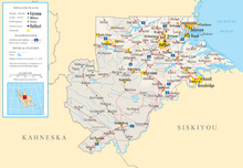
Josephinia, officially the Commonwealth of Josephinia (Ínts’o: 𐒿𐓂͘𐓄𐒰 𐓀𐒰͘𐓓𐒰͘ 𐓁𐒻 𐓓𐓎𐓊𐒷, hernicized: Sopʼa Mąžą Ni Žucʼe), is a sovereign state in Elia Borealis. It is bounded to the north by X, to the west and southwest by Kahneska, to the southeast by Siskiyou, and to the east by the Northern Alconian Ocean. Its capital is Haliburt while its largest city is Port Royal; other major population centers include Delamore, Gracebridge, Sequaneake, Providence, Fairview, Hamill, Pembroke, and Springfield. With a population of approximately 6.3 million, it is the fifth-most and least populous country in Elia Borealis, but its most densely populated. Josephinia spans 101,827 km2 (39,316 sq mi), making it the single-smallest country on the continent and among the smallest in the Elias.
Josephinia is located on the middle section of the Elian Alconian Plain, the foothill region of the Abaroskine Mountains which crosses the country diagonally from north-west to south-east; the adjacent Big Misty Mountains form the natural boundary to Kahneska. The centrally located Golden Valley is the country's breadbasket and the most fertile region. The densely populated coastal areas around Sequaneake Bay are largely shaped by drowned river valleys, low firths, and tidal marshes known as the Tidewash.
Various native Elian tribes have inhabited the territory of modern-day Josephinia for at least 11,000 years, including the Polhetan and the eastern Ama, and occasional Yinese expeditions throughout the 14th century pioneered Elian exploration. In 1515, Waldish discoverer Anders Barpfyld became the first known Calesian to make landfall in the region and established the first provisional Waldish colony in the New World with Frederikshavn. Subsequently, in 1714, Falland seized control and the United Wixdon Company created the Colony of Cisylvania around the trading posts of Port Royal and Delamore. Renamed in 1726, the inhabitants of now Josephinia fought for independence in the Elian Wars of Independence beginning in 1759 and achieved statehood within the fledging Grand Federation in 1790.
Dissatisfied with Fallish authority in Calesia, religiously prosecuted Cowerers and other minorities flocked to Josephinia en masse in the early 19th century, nearly quadrupling the state's population within the span of 20 years. By 1850, the so-called Steaders had repeatedly violated the Proclaimed Demarcation Line of 1757 and began to settle and colonize the continent's interior from the eastern frontier; the native populations were, often times violently, displaced. Following an armed rebellion amidst the 1880s Land Rush, the weakening Grand Federation recognized the approximately 1.1 million Steaders' independence beyond the Big Misty Mountains through the 1889 Casper Convention. The Elian Civil War coincided with a final attempt by the Free States to seize back control over Josephinia, before such desires permanently ceased and the Grand Federation was dissolved in 1896.
Over the course of the 20th century, Josephinia was subject to an alternating series of civil and democratic governments and military juntas; the near century-long one-party rule of the National Party dominated Josephinian politics, gradually strengthening racial segregation to impose a herrenvolk democracy while rapidly industrializing the formerly protectionist agrarian economy. In 1920 and 1944, the military repeatedly seized control, particularly in precipitation of the Elian Border Wars. Amidst mounting international sanctions by its continental neighbors, most notably by Kahneska, Josephinia under Winston Derrier conceded to majority rule and amended the constitution to formally abolish racially motivated hindrances for the native population in 1977, initiating a process of societal democratization.
A developed country, Josephinia ranks highly in international measures of quality of life, human rights, and suppressed corruption, but still retains a significant economic inequality between the white and native populations. Nationally, legislative power is vested in the unicameral National Parliament, while executive power is exercised by the President heading the Government. Josephinia is a member state of the United Congress, Organization of Elian States, Fallish Community, Alconian Forum, and the X, and it enjoys particularly close relations with Falland and with the Free States.
Etymology

The name Josephinia is derived from the middle name of Princess Louise Josephine of Robindy, daughter of X. It was initially conceived as a gift to honor the royal princess for her 35th birthday in 1726, who had previously demonstrated a great personal interest in the indigenous cultures of the New World. It was eventually adopted by the Republic of Josephinia of 1884 when it declared its independence and ultimately remained.
Before the name change, the colony itself was initially named Cisylvania by Fallish colonial governor Edward Mary Dollingham of the United Wixdon Company in 1714, from the Hernician words for 'on the same side as' (cis-) and the accusative case of 'forest' (silva, sylvam; also meaning 'woods'), literally meaning 'on this side of the forest'.
The Ínts’o name for Josephinia comes from the phrase 𐓁𐒻, hernicized as Ni, 'red', and 𐓓𐓎𐓊𐒷, hernicized as Žucʼe, meaning 'river' or 'creek'. Ínts’o Nation Chief Alexander Warren suggested the name in 1811 to the state government of Josephinia for use, envisioning a renaming of the country in favor of the fallisized Nizuca; while initially contemplated, it was never officially implemented. What the name was referencing remains disputed, though historians largely agree it alluded to the typical red-brownish sediments carried by the Pequennock River.
To refer to this country, the Josephinian government uses the terms Josephinia, Commonwealth of Josephinia, and Josephine Commonwealth.
History
Prehistory
Denvsoqua period
Waldish and Fallish colonization
Steader migration

Independence
Contemporary period
Geography
Josephinia is located in the Alconian Region of Elia Borealis, and it borders X (510 km; 317 mi) to the north, Kahneska (230 km; 143 mi) to the east and southwest, and Siskiyou (495 km; 308 mi) to the south and southeast. The boundary to X was defined in 1715 as 50°15' north latitude, while the boundary to Siskiyou is largely predominated by the Pequennock River. The territorial extent of Josephinia covers an area of 101,827 km2 (or 39,316 sq mi), 3.3% or 3,360.3 km2 (1,297.4 sq mi) of which are areas of water; this makes Josephinia the smallest country by size in Elia Borealis and the second-smallest country in the Elias. It lies between latitudes 50°16' and 47°58' N, and longitudes 66°20' and 71°44' E.
Despite its comparatively small size, Josephinia features a number of distinctive topographic regions. Sequaneake Bay is one of the largest natural harbours in the world and the estuary of most of Josephinia's major rivers, including the Pequennock, Comey, James, and Revsdal. The Tidewash of the Elian Alconian Plain is a large coastal plain between the Alconian Ocean and the region's escarpment in the eastern section of the country that is inhabited by a majority of its population, shaped by drowned river valleys and extensive tidal marshes as well as a forelying string of barrier islands. The igneous foothills give way to the carbonate-sedimentary Big Misty Mountains in the west, a physiographic province of the Abaroskine Mountains, with the highest point being Frontier Peak at 1,698 m (5,571 ft). The Great Elian Valley, which is called the Golden Valley in Josephinia, extends beyond it, as are the Namtahala Plateau and the Travis Mountains. In the north, the flat-topped tablelands of the Blue Mountains are a portion of the northern terminus of the Abaroskines.
The country's varied geological composition allowed for the historic creation of numerous karsts and more than 3,500 limestone caves, including the popular Great Ignasian Caves, the third-longest known cave system in the world. The Namtahala Plateau is also the site of many scenic waterfalls and cliffsides. A traditional mining economy, Josephinia is the world's fourth-largest producer of slate, kyanite, and ilmenite, and it is the sixth-largest exporter of coal. A historical deposit of uranium, the third-largest of its kind, is also located at Collett's Deep.
Climate
Biodiversity
Government and politics
Josephinia is a unitary presidential representative democracy, as codified and set by its Constitution. Exercising the separation of powers, the country's political system is divided into the executive, legislative, and judicial branch, each controlled by a separate institution. Formally and de jure, the President is the head of the executive branch and, therefore, the head of state and head of government, the commander-in-chief of the armed forces, and the most influential political instance in Josephinian politics. The President is responsible for appointing a cabinet of ministers and has the responsibility to sign and veto bills. The current President is Lloyd Gladstone since 2022.
The unicameral National Parliament is the unified legislature. It is directly elected using the mixed-member proportional representation and parallel voting systems with plurality vote in single-member districts. The National Parliament can make national law, issue a state of war and taxation, and approve of the national budget and the ministers nominated by the President. It has 149 voting members elected to an unlimited number of four-year terms; at least one third of the candidates presented by the parties must have native heritage.
The judiciary is embodied in the Supreme Court, the nation's highest court of appeal and comprised of 10 judges nominated by the President and approved by the National Parliament. It is the country's official source of law and protector of the Constitution, enabled to overturn bills that it deems unconstitutional. The political system is laid out by the frameworks of the supreme constitutional document last amended in 1977. Essential concepts of the system, such as the unitary structure, respect for human rights, and the rule of law are protected by a status of perpetual validity. Direct democracy is supported through the availability of protests, referenda, a multi-party system and accountancy of the government, and guaranteed freedoms of expression, assembly, secret ballot, and universal suffrage beginning at age 18.
In Josephinia's political history, the respective catch-all parties of the right-wing National Party and the left-wing Labour Party as well as its predecessors have been the dominant parties, with almost every President to date having been a member of either. However, several independent politicians and minor parties have achieved representation in the National Parliament: the Progressive Caucus and the Josephinian Greens are the third and fourth largest party, respectively, and have on multiple occasions proven to be decisive when forming coalition governments to avoid minority.
Foreign relations
Military
Law
Administrative divisions
Economy
Infrastructure
Agriculture
Mining
Tourism
Demographics
Languages
Religion
Education
Health
Cities and towns
Largest cities in Josephinia
National Census Office estimates (2021) | |||||||||
|---|---|---|---|---|---|---|---|---|---|
| Rank | Region | Pop. | Rank | Region | Pop. | ||||
 Port Royal  Haliburt |
1 | Port Royal | Port Royal | 734,732 | 11 | Aconahee | Pequennock | 82,752 | Delamore  Sequaneake |
| 2 | Haliburt | Haliburt | 314,503 | 12 | Durhamsburg | Haliburt | 75,208 | ||
| 3 | Delamore | Sequaneake | 245,590 | 13 | Oxcross | Treaty | 63,597 | ||
| 4 | Sequaneake | Sequaneake | 225,428 | 14 | Kingston | Haliburt | 61,410 | ||
| 5 | Providence | Providence | 181,172 | 15 | Namtahala | Abaroskine | 49,045 | ||
| 6 | Gracebridge | Pequennock | 160,338 | 16 | Fort Scott | Pequennock | 45,097 | ||
| 7 | Fairview | Golden Valley | 127,650 | 17 | Rupertsburg | Golden Valley | 44,659 | ||
| 8 | Hamill | Pequennock | 123,344 | 18 | Manassas | Haliburt | 42,027 | ||
| 9 | Pembroke | Treaty | 100,693 | 19 | Treaty Forge | Treaty | 41,841 | ||
| 10 | Springfield | Golden Valley | 92,234 | 20 | Fort Trumblin | Abaroskine | 39,919 | ||


