Miersan Section of the Workers' International
Jump to navigation
Jump to search
Miersan Socialist Republic Republika Mierski Socjalistyczna | |
|---|---|
Coat of arms
| |
| Motto: "Przerwij Łańcuchy!" "Break the Chains!" | |
| Anthem: Hymn Republiki Socjalistycznej "Hymn of the Socialist Republic" | |
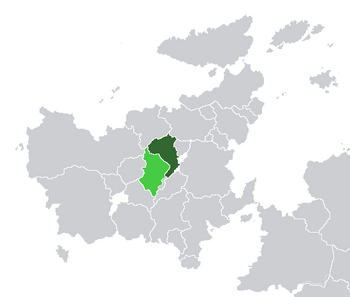
 Location of East Miersa (dark green) and claimed but uncontrolled territories (light green) in Euclea. | |
| Capital | Żobrodź (de jure) Dyńsk (de facto) |
| Largest city | Dyńsk |
| Official languages | Miersan |
| Recognised regional languages | Orimiersan |
| Ethnic groups (2016) | Miersan (78.6%) Orimiersan (17.2%) Other (15.2%) |
| Religion (2016) | Irreligious (54.2%) Catholicism (27.4%) Episemialism (11.8%) Other (6.6%) |
| Demonym(s) | East Miersan Miersan |
| Government | Federal socialist council republic |
• Premier | Anna Wlodarska |
| Legislature | People's Congress |
| Formation | |
• Union of the Three Crowns | 1257 |
• Interregnum | 1658 |
• Partition | ???? |
• Godfredson Plan | 1936 |
• Treaty of San Alessandro | 1982 |
| Area | |
• Total | 197,568 km2 (76,281 sq mi) |
| Population | |
• 2017 estimate | 21,740,000 |
| GDP (nominal) | 2015 estimate |
• Total | $562.718 billion |
• Per capita | $25,884 |
| Internet TLD | .miw |
The Miersan Socialist Republic (Miersan: Republika Mierski Socjalistyczna), also known as East Miersa (Miersan: Mierska Wschodnia), is a sovereign state in central Euclea, comprising the eastern portion of the historical nation of Miersa. It is bordered by Velzemia and Swetania to the north, by Aimilia and Gaullica to the east, ??? to the south and West Miersa to the west. The country has an area of 197,568 km2 (76,281 sq mi) and a population of 21.7 million. According to the constitution, Żobrodź is the de jure capital, but Dyńsk is the de facto seat of government.
