Caluchia
This article is incomplete because it is pending further input from participants, or it is a work-in-progress by one author. Please comment on this article's talk page to share your input, comments and questions. Note: To contribute to this article, you may need to seek help from the author(s) of this page. |
Caluchian Republic Republika Kaluchiana
(Bahiano Creole) | |
|---|---|
|
Flag | |
| Motto: "Giù con i schiavisti, su con la stella"
"Down with the slavers, up with the star" | |
 | |
| Official languages | Vespasian, Bahiano Creole, Itaheuchan |
| Establishment | |
• The Poveglian colony of Francescia is officially established | 1556 |
• Francescia conquers the coastal plain and most of the Altipiano | 1559-1563 |
• The first slave ship arrives in San Matteo, beginning the period of Bahian slavery in Caluchia | 1581 |
• The First Caluchian Republic is proclaimed following a widespread and successful slave revolt | 1799 |
• The Second Caluchian Republic is established after the victory of the Grand Alliance in the Great War and the end of Satucinais occupation | 1935 |
• Generalissimo Berto Fierro overthrows the government and establishes the Most Holy State of Caluchia, a semi-theocratic military dictatorship | 1963 |
• The Third Caluchian Republic is established after the September Rising | 1981 |
| Date format | dd-mm-yy |
| Driving side | right |
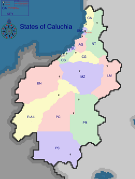
Caluchia (Vespasian: Calucia, Bahiano Creole: Kaluchia, Itaheuchan: Mapu Caleuche), officially the Caluchian Republic, is a sovereign nation in northeastern Asteria Inferior on the planet Kylaris. The country is composed of four main geographic regions Northern Caluchia is composed of a flat and fertile subtropical coastal plain. Further inland, elevation increases steadily and then plateaus, forming a region of high plains, or the Altipiano in Vespasian. Southwest of the Altipiano lies the Colline Rossa, a swathe of rugged hills mostly populated by indigenous Itaheuche. Beyond the Colline Rossa in the southwest, and directly south of the Altipiano in the southeast, the Sierra Bianca mountain range divides northern Caluchia from the southern grasslands of the Grande Pianura. Most passes through the mountains are narrow and not suitable for car or train travel, but roads and railways through the Passa Vittoria have allowed cheap and efficient transit through the mountains since the mid 19th century CE.
Etymology
History
Politics
Geography
Largest cities or towns in Caluchia
Caluchian Census Ministry, 2018 | |||||||||
|---|---|---|---|---|---|---|---|---|---|
| Rank | State | Pop. | |||||||
| 1 | San Matteo | San Matteo | 2,223,000 | ||||||
| 2 | Fonte Fresca | Pianura Occidentale | 1,200,000 | ||||||
| 3 | Città Buonarotti | San Lorenzo | 670,000 | ||||||
| 4 | Porto Fausto | Porto Fausto | 500,000 | ||||||
| 5 | Gabrielli | Bonifacia | 380,000 | ||||||
| 6 | Quilacoyan | Regione Autonoma Itaheuche | 185,000 | ||||||
| 7 | [[{{{city_7}}}]] | [[{{{div_7}}}]] | {{{pop_7}}} | ||||||
| 8 | [[{{{city_8}}}]] | [[{{{div_8}}}]] | {{{pop_8}}} | ||||||
| 9 | [[{{{city_9}}}]] | [[{{{div_9}}}]] | {{{pop_9}}} | ||||||
| 10 | [[{{{city_10}}}]] | [[{{{div_10}}}]] | {{{pop_10}}} | ||||||
