Kama
Kama | |
|---|---|
 Old Town of Kama | |
 | |
| Settled | 43 BC |
| Founded by | Lucius Munatius Plancus |
| Government | |
| • Body | Municipal Assembly of the Free City of Kama |
| Area | |
| • Capital city of Kamany | 56,229 km2 (21,710 sq mi) |
| Population | |
| • Urban | 3,294,396 |
| • Metro | 4,326,736 |
| Demonym | Kamian |
| Website | www.ciutatkama.kk |
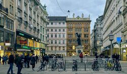
Kama [ɡama'] is the capital and largest city of Kamany. It is also the capital of the Region of Kama. The population of the proper city is 3,294,396 in 2020 while the population of the metropolitan are is estimated to be more than 5 million inhabitants. The city has a rich culture and history and is supposed to be populated since the bronze age. Kama is well known for its medieval old town, its Renaissance castle, its Rococo palaces, Art Nouveau neighbourhoods and modern buildings.
Geography
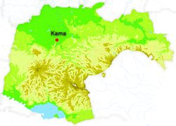
The city of Kama covers 562,29 km² and is located in northwestern Kamany along the river Flaa in the Region of Kama. The city is spread on a large valley in the north of Peninae Mountains also comprising the rivers Galio and Arbela. Kama is relatively flat, the lowest point is 210 metres above sea level and the highest point is at 330 metres.
Kama can be described as having a humid subtropical climate, Cfa classification, summers are hot and wet and mild to cold winters. Precipitations are important, especially in summer and autumn.
| Climate data for Kama meteorological station Castel, 1981–2015 normals, extremes 1946–present | |||||||||||||
|---|---|---|---|---|---|---|---|---|---|---|---|---|---|
| Month | Jan | Feb | Mar | Apr | May | Jun | Jul | Aug | Sep | Oct | Nov | Dec | Year |
| Record high °C (°F) | 25.1 (77.2) |
26.6 (79.9) |
27.4 (81.3) |
31.0 (87.8) |
32.3 (90.1) |
35.6 (96.1) |
36.8 (98.2) |
37.1 (98.8) |
32.2 (90.0) |
30.0 (86.0) |
22.8 (73.0) |
21.4 (70.5) |
37.1 (98.8) |
| Average high °C (°F) | 6.6 (43.9) |
9.1 (48.4) |
13.4 (56.1) |
16.6 (61.9) |
20.7 (69.3) |
24.8 (76.6) |
27.9 (82.2) |
27.1 (80.8) |
23.0 (73.4) |
17.3 (63.1) |
11.1 (52.0) |
7.6 (45.7) |
17.1 (62.8) |
| Daily mean °C (°F) | 2.0 (35.6) |
4.3 (39.7) |
8.1 (46.6) |
11.1 (52.0) |
15.5 (59.9) |
19.4 (66.9) |
22.4 (72.3) |
21.8 (71.2) |
17.8 (64.0) |
12.4 (54.3) |
6.5 (43.7) |
3.1 (37.6) |
12.0 (53.6) |
| Average low °C (°F) | −2.5 (27.5) |
−0.7 (30.7) |
2.7 (36.9) |
5.7 (42.3) |
10.4 (50.7) |
14.0 (57.2) |
16.9 (62.4) |
16.5 (61.7) |
12.7 (54.9) |
7.4 (45.3) |
1.9 (35.4) |
−1.6 (29.1) |
7.0 (44.6) |
| Record low °C (°F) | −18.5 (−1.3) |
−21.8 (−7.2) |
−10.5 (13.1) |
−3.8 (25.2) |
−2.3 (27.9) |
4.3 (39.7) |
6.6 (43.9) |
6.3 (43.3) |
1.8 (35.2) |
−3.9 (25.0) |
−8.2 (17.2) |
−13.8 (7.2) |
−21.8 (−7.2) |
| Average precipitation mm (inches) | 47.8 (1.88) |
47.1 (1.85) |
72.5 (2.85) |
113.3 (4.46) |
145.3 (5.72) |
104.3 (4.11) |
70.5 (2.78) |
76.1 (3.00) |
83.8 (3.30) |
106.1 (4.18) |
69.1 (2.72) |
45.1 (1.78) |
981.0 (38.62) |
| Average precipitation days (≥ 1.0 mm) | 5.4 | 4.4 | 5.8 | 8.6 | 11.2 | 8.6 | 5.8 | 7.7 | 6.4 | 7.0 | 5.6 | 4.4 | 80.9 |
| Average relative humidity (%) | 75 | 75 | 67 | 72 | 75 | 74 | 72 | 73 | 75 | 79 | 80 | 80 | 75 |
| Mean monthly sunshine hours | 111.6 | 118.7 | 158.1 | 180.0 | 195.3 | 219.0 | 260.4 | 223.2 | 168.0 | 142.6 | 105.0 | 108.5 | 1,990.4 |
| Source: Instituto Federal de Meteorologia (IFM) | |||||||||||||

