Kobi
Kobi | |
|---|---|
 | |
| Country | Akashi |
| Capital | Rumoi |
| Area | |
| • Total | 22,847 km2 (8,821 sq mi) |
| Population (2020) | |
| • Total | 1,176,431 |
| • Density | 51/km2 (130/sq mi) |
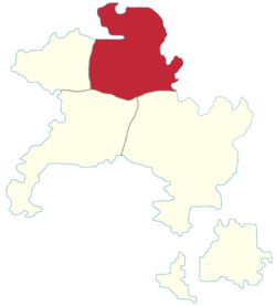
Kobi (Miranian: 虎尾; Gothic: ᚴ𐍉𐌱𐌹; abbreviated KO) is a province of Akashi. Located in the north, it borders Takao to the west, Kagi to the south-east, and Matō to the south-west.
Geography
The province's territory is largely mountainous, holding both the ends of the Tōhō Sanmyaku and Seihō Sanmyaku, and the start of the Furēya river basin. The north coast is largely flat, and there is a small plateau towards the eastern border, where Yoshino is located.
The largest rivers are Furēya in the south and various tributaries (with Rumoi located at one of their confluences).
Demographics
The 2020 census recorded a population of 1.176.431, making it Akashi's most populated province. The largest cities are:
- Rumoi — the regional capital.
- Honnobe — one of Akashi's most industrialised cities, traditionally nicknamed Kuroimachi (黒い街; "black town") due to its factories.
- Eisen — Akashi's northernmost port.
- Yoshino
Economy
Kobi's economy has traditionally been based on industry, and it remains a centre of Akashian manufacturing.
The large cities' economies have transitioned from industry towards services and tourism.
Politics
Kobi is a strongly leftist province, and a traditional stronghold of the Communist Party.