Kagi
Kagi | |
|---|---|
 | |
| Country | Akashi |
| Capital | Mikasa |
| Area | |
| • Total | 25,585 km2 (9,878 sq mi) |
| Population (2020) | |
| • Total | 3,484,879 |
| • Density | 140/km2 (350/sq mi) |
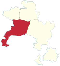
Kagi (Miranian: 嘉義; Gothic: ᚴ𐌰𐌲𐌹; abbreviated KA) is a province of Akashi. Located in the west, it borders Takao to the north, Kobi to the north-east and Matō to the east.
Its name comes from the distinctive shape of the Kagi (鉤; "hook") peninsula.
Geography
The province's territory is dominated by the Seihō Sanmyaku in the north and centre, with hills in the Kagi peninsula to the south-west, and rolling plains in the rest of the province.
Most of eastern Kagi is part of the Furēya river basin. The other large rivers are Akangawa in the west (with Shinchiku located at its confluence with the Bara Sea) and Takinokawa in the south (with Mizuho located at its confluence with the Bara Sea).
Demographics
The 2020 census recorded a population of 3.484.879. The largest cities are:
- Mikasa — the regional capital.
- Shinchiku
- Mizuho
- Kotobuki — famed for its canals on the banks of the Furēya.
Economy
Kagi's economy is dominated by industry, agriculture, and tourism.
Mikasa, Mizuho, and Shinchiku are large ports. Shinchiku and Mizuho are strongly industrialised. Kotobuki's economy is mainly based on tourism and the food industry.
Politics
Kagi is seen a political bellwether of Akashi, having historically given pluralities to parties that formed or were part of the governing coalitions since 1970.