Strait of Budoc
This article is incomplete because it is pending further input from participants, or it is a work-in-progress by one author. Please comment on this article's talk page to share your input, comments and questions. Note: To contribute to this article, you may need to seek help from the author(s) of this page. |
| Strait of Budoc | |
|---|---|
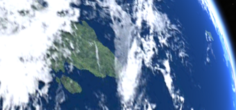
 The Strait of Budoc viewed from Space | |
| Location | Argis, Geltic sea |
| Coordinates | Coordinates: |
| Type | Strait |
| Basin countries | |
| Min. width | 22 km (14 mi) |
| Surface area | 51,600 square kilometres (19,940 sq mi) |
| Max. depth | 198.0 metres (649.6 ft) |
| wikipedia:Salinity | 3.4% |
The Strait of Budoc (Aurivizht: Strizh-Mor Budoc; Ebrarese: Stricto de Insmerda; Gallasian: Culfor Budoc) is a narrow strait between the Country of Aurivizh, on the continent of Argis, and the Argic island of Bouenezenn.
The two landmasses are seperated by 22.7 kilometres at the narrowest point at Ber Fulenn in Aurivizh and Kab ar Norzh on Bouenezenn. Two bridges, one road and one rail, cross the strait, connecting Aurivizh and the Aurivizht State of Bouenezenn. Ferries cross the distance in a hour. The Strait's depth ranges between 50 and 200 metres, and lies in the territorial waters of Aurivizh, Bouenezenn and Insmerda. Foreign vessels and aircraft have the freedom of navigation and overflight to cross the strait of Budoc in case of continuous transit, but due to the construction of the two Budoc bridges, strict height-restrictions have been put in place.
