Central Territory
Jump to navigation
Jump to search
Central Territory | |
|---|---|
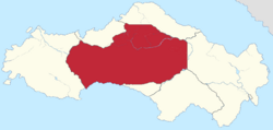
 Location of the Central Territory in Satavia | |
| Country | Satavia |
| At Federation | Central & Western Territories |
| Establishment | 1 October 1816 |
| Territorial Authority | 25 December 1976 |
| Attained parity | 31 December 1999 |
| Capital and largest city | Hondeburg |
| Administration | 8 districts |
| Official languages | |
| Demonym(s) | |
| Government | |
| James Pienaar | |
• Premier | Louis Plummer |
| Legislature | Pioneer Assembly |
| Parliament of Satavia | |
• Senate | 12 senators (of 96) |
| 1 seats (of 152) | |
| Area | |
• Total | 186,620 km2 (72,050 sq mi) (1st) |
| Population | |
• 2022 census | 204,198 (8th) |
• Density | 1.09/km2 (2.8/sq mi) (8th) |
| ISO 3166 code | SV-CT |
| Website | ct |
The Central Territory, commonly referred to by its initials CT, is the largest territory of Satavia by land area and the least populous. It occupies much of the interior of the country, and is home to Satavia's largest single rainforest. It borders all six provinces to the north, east, south and west. To the north, it is geographically bound by the Orange Mountains, to the south east by the Rogue River, to the west by the Hex River and to the north west by the Crocodile River.
