Holy Land (CCA)
| The Holy Land | |
|---|---|
| Native names Hebbi: אֶרֶץ הַקּוֹדֶשׁ Verdusi: Terra Sancta Emmirian: الأرض المقدسة | |
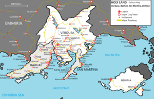
 A political map of the Holy Land | |
| Type | Holy place |
| Location | Region between the Haifan Sea, Emmiria Sea |
The Holy Land is a region in southeast Adula considered holy to the three major Abrahamic religions— Judaism, Christianity, and Islam, as well as Rajitism. The region is defined by the Verdusa corridor, a series of peninsulas jutting into the Emmiria Sea and defined by the Haifan Sea. In the modern day, it is comprised of the nations of Verdusa, Rajihat, San Martina, and Behinia, with some descriptions also extending the Holy Land as far west as Al-Makkah in Emmiria. The significance of the land largely lies in its importance to biblical settings, and the 'center' of the Holy Land is the holy city of Yerusalahm. Many sites in the Holy Land have long been pilgrimage destinations for adherents of the Abrahamic religions, including Jews, Christians, Muslims, and Rajits.