Adula
 | |
| Population | 4.3 Billion |
|---|---|
| Population density | 100/km2 |
| GDP (PPP) | $65.44 trillion |
| GDP per capita | $7,350 |
| Countries | List of sovereign states and dependent territories (Iearth) |
| Largest cities | |
Adula is the second-largest continent located on the planet of Iearth. The vast continent is bounded by the bustling Olympic Ocean and Toyana Ocean to the east and the Samson Ocean to the west. It is bisected from Euronia at the Western Zamastan islands by the Strait of Quetana, from Nortua at Birnir by the waterway of Yn Syth and at Grelend by the Strait of Grelend, and from Antartique by the Strait of Drendarich.
Given its size and diversity, the concept of Adula—a name dating back to classical antiquity—may actually have more to do with human geography than physical geography. Adula varies greatly across and within its regions with regard to ethnic groups, cultures, environments, economics, historical ties and government systems. It also has a mix of many different climates ranging from the equatorial south via the hot desert in the East, temperate areas in the south-central regions and the continental center to tropical western divisions.
Adula is home to some of the most influential nations in the world both in terms of historical impact and modern day connection, including Cadair, Emmiria, Austrolis, Quetana, and Skith.
Etymology

Adula was originally a concept of Verdusan civilization in the 6th century B.C.E., with the idea of an extensive landmass beyond the deserts of Emmiria that flourished with lucrative kingdoms connected by networks, such as the Bezdekia Road linking modern-day Mulfulira with Zudrait, being some of the first commonly used trading routes in the world.
History

The history of Adula can be seen as the distinct histories of several peripheral coastal regions: East Adula, South Adula, West Adula and Central Adula, linked by the interior mass of the Central Adula steppes and prairies. The coastal periphery was home to some of the world's earliest known civilizations, each of them developing around fertile river valleys. The Western civilizations in Southwest and Northwest Cadair and Prydania shared many similarities. These civilizations may well have exchanged technologies and ideas such as mathematics and the domestication of the horse. Other innovations, such as writing, seem to have been developed individually in each area, most earliest in Quetana, Verdusa, Skith, and Emmiria in the East. Cities, states and empires developed in these lowland river valleys and coastal regions. The central steppe region had long been inhabited by horse-mounted nomads who could reach all areas of Adula from the steppes. The earliest postulated expansion out of the steppe is that of the Somodi and the Kagreau, who spread their languages into the south-west of Adula via the Bezdekia Road, which was one of the first trading routes that connected the continent from East to West.
Bronze Age
The Cardiff Civilization in Cadair was a Bronze Age civilization (3300–1300 BCE; mature period 2600–1900 BCE) which was centered mostly in the central-west coast of Adula; it is considered that an early form of *Cadair Religion* was performed during this civilization. Some of the great cities of this civilization had high levels of town planning and arts. The cause of the destruction of these regions around 1700 BCE is debatable, although evidence suggests it was caused by natural disasters (especially flooding).
Adula also had some of the earliest centers of metalworking. Dating back to the Neolithic Age, the first bronze drums have been uncovered in and around the Neidr River Delta regions of Cadair as well as evidence of skilled craftsmen making weaponry from Artegana and Serra Leon. Early examples of iron tools and weaponry began appearing across Adula by the 1100's BCE, including the famous Blackfront Amulet, the earliest known example of worked steel.
In Ban Congan, Kantoalina (Southwest Adula), bronze artifacts have been discovered dating to 2100 BCE.
1st-10th Century

11th-15th Century
Modern History

In 1830, the imperial forces of Skith kickstarted the Barretoan Wars when Bento Barreto invaded northern Emmiria through Jiddiya. A coalition of central Adulan nations, led by Durnstaal, Alcarres, and Alonnisosa, joined forces with Emmiria to push the Skithans back. As Timerian navy battled Skithan imperial fleets in the Emmiria Sea and Croix Sea, the armies in Adula waged a prolonged war that ultimately resulted in Skith losing their colonies in Southern and Eastern Adula, including the independence of Quetana.
Geography
Regions

Adula, due to its immense size, is generally divided into five subcontinental categories: East, Central, Somodi, Cadairi, and South. These are generally categorized by wildly diverse geographical features.
- East
Eastern Adula's climate and geography is varied, as the south tends to be more dry consisting of deserts and semi-arid climates, and the north becomes more temperate, containing vast expanses of forest and fertile valleys. The region consists of grasslands, rangelands, deserts, and mountains. Water shortages are a problem in many parts of East Adula, particularly in the desertificated nations like Emmiria, Saudi Jiddiya, Sulifa, and Khaytan, with rapidly growing populations increasing demands for water, while salinization and pollution threaten water supplies. Along the coasts, it exhibits a mixture of temperate and tropical climates.
- Central
The Central region's climate varies considerably from area to area, from alternating arid and tropical zones in the south to temperate in the north. Much of the region is characterized by plateaus, and it is generally the flattest area on the continent with especially treeless, grassy steppes. Expansive forests largely exist closer to the coasts, while the interior is largely steppe and grassland. Few mountain ranges exist, mostly along the geographic boundary with the east in the form of the Kalater Mountains in Durnstaal and Alcarres. The Adulan Grass-Steppe of the temperate grasslands, savannas, and shrublands had a role in the spread of the horse, the wheel, and the Adulan languages along the Bezdekia Road.
- Somodi
Descending from the Cadair Alps towards the Strait of Austrolis with temperate deciduous forest, the climate of this vast region varies considerably from area to area from tropical monsoon in the north to temperate in the south. The variety is influenced by not only the altitude but also by factors such as proximity to the seacoast and the seasonal impact of the Albarine Sea monsoons. Northern parts are mostly hot in summers and receive rain during monsoon periods. The interior belt of Somodi plains are is hot in summer, but cooler in winter. The mountainous west is colder and receives snowfall at higher altitudes of Cadair Alps.
As the Alps create a mild rain shadow that prevents bitter winds, the temperatures are considerably moderate in the plains down below. For the most part, the climate of the region is called the Monsoon climate, which keeps the region humid during summer and dry during winter, and favours the cultivation of jute, tea, rice, and various vegetables in this region. The nations of Timeria, Somodi, Azil, and Austrolis share the majority of the region's watershed.
- Cadairi
Cadairi is typically more humid and consists of tropical rainforests on the Samson Ocean side, ascending into high-altitude mountains of the Cadair Alps which demark the geographical border with Somodi. The world's tallest mountain, Mount Glyder Fawr (elv. 31,021 feet), is on the border of Cadair and Somodi.
- South
The southern division is most distinguishable due to its status as a centrally located island and surrounding islands separated from mainland Adula. The islands are largely mountainous. The westernmost islands, often referred to as Sera, is divided into two geographical zones; the southern two-thirds largely being dry and arid and consisting of desert and savannah, specifically in Zalluabed, Unified Sera, and Togaria; the northern third is more temperate, with rigged hillscapes and sparsely wooded forests. The easternmost islands, separated from the western ones by way of the Emmiria Sea and the Gulf of Semelia, are collectively referred to as Croix and follow a similar climate makeup with dry, arid zones separated by more temperate, forested zones.
Ecology and Biodiversity
Fauna
The presence of man affected the distribution of Adulan fauna. As for the animals, in many parts of Adula most large animals and top predator species have been hunted to extinction. The woolly mammoth was extinct before the end of the Neolithic period. Today wolves (carnivores) and bears (omnivores) are endangered. Once they were found in most parts of Adula. However, deforestation and hunting caused these animals to withdraw further and further.
Adulan wild cat, foxes (especially the red fox), jackal and different species of martens, hedgehogs, different species of reptiles (like snakes such as vipers and grass snakes) and amphibians, different birds (owls, hawks and other birds of prey).
Important Adulan herbivores are snails, larvae, fish, different birds, and mammals, like rodents, deer and roe deer, boars, and living in the mountains, marmots, steinbocks, chamois among others. A number of insects, such as the small tortoiseshell butterfly, add to the biodiversity.
Adula still boasts perhaps the world's largest combination of density and "range of freedom" of wild animal populations and diversity, with significant (albiet disproportionate and sustained by human intervention and conservation) wild populations of large carnivores (such as lions, hyenas, and cheetahs) and herbivores (such as buffalo, elephants, and camels) ranging freely on primarily open non-private plains. It is also home to a variety of "jungle" animals including snakes and primates and aquatic life such as crocodiles and amphibians. In addition, Adula has the largest number of megafauna species, as it was least affected by the extinction of the Pleistocene megafauna.
Sea creatures are also an important part of Adula flora and fauna. The sea flora is mainly phytoplankton. Important animals that live in Adulan seas are zooplankton, molluscs, echinoderms, different crustaceans, squids and octopuses, fish, dolphins, and whales.
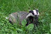
Badger in Vitosium

Gorilla in northern Serra Leon

Giraffe in Peoratia

East Adula hare in Quetana

Hippopotamus in Timeria

Zebras in Unified Sera
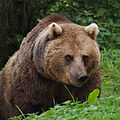
Brown bear in Kuresa

Chimpanzee in Qolaysia
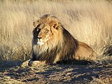
Lion in Emmiria

Gerenuk in Kossmil

Cheetah in Khaytan
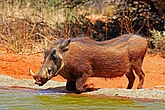
Warthog in Zalluabed
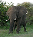
Adulan elephant in Cadair

Adulan rhino in Artegana

Fish otter in Durnstaal

Kiwa in Elborra

South Adula lynx in Alecburgh

Kudu in Mulfulira


-cropped.jpg)
_(16485955207).jpg)


_feeding.jpg)


_male.jpg)
_male_(17289351322).jpg)


,_La_Lancha,_Parque_natural_de_la_Sierra_de_And%C3%BAjar,_Andaluc%C3%ADa,_Espa%C3%B1a_-_Flickr_-_Frank.Vassen.jpg)
.jpg)
