Russa
This article is incomplete because it is pending further input from participants, or it is a work-in-progress by one author. Please comment on this article's talk page to share your input, comments and questions. Note: To contribute to this article, you may need to seek help from the author(s) of this page. |
| Russa | |
|---|---|
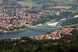
 The Russa River at Pontenouvo | |
| Location | |
| Country | |
| States (Barcian) |
|
| Largest cities | |
| Region | Eastern Occidental Auressia |
| Physical characteristics | |
| Source | Benemian mountains |
| - elevation | 784 m (2,572 ft) |
| Mouth | Porto Bay, Galene Sea |
• elevation | 0 m (0 ft) |
| Length | 1,234 km (766.7 mi) |
The Russa is the longest river in Barcia and one of the major rivers within Occidental Auressia. The river originates in Palia in the Benemian mountains and flows from south to north passing through the Barcian regions of Benemia, Forlana and Concara. The mouth of the river is located at Porto Bay in the Galene Sea. The Russa is perhaps the most important river in Barcia and is central to the country's river system within the Forlana valley where much of the country's population is located. Major cities along the river Russa include Vicenze, Cerbana, San Filano and Porto as well as the Barcian capital and largest city, Tradare. The Russa has a number of tributaries, the most notable being the River Belo along which can be found important cities such as Telona and Bergamate.
The River Russa has a rich history in Barcia dating back to the pre-Sabarine period where the river played host to many Barcii settlements. Following the Sabarine conquest the river would be incredibly important for trade, allowing for the flow of goods from central Occidental Auressia, across the Galene Sea and vice versa. Additionally, the river would also facilitate widespread Isaric raiding during the Eighth to Eleventh century, playing an important role in helping the Ludovites to extend their control across Barcia.