User:Concleror/sandbox 4
This article is incomplete because it is pending further input from participants, or it is a work-in-progress by one author. Please comment on this article's talk page to share your input, comments and questions. Note: To contribute to this article, you may need to seek help from the author(s) of this page. |
Commonwealth of Josephinia 𐒿𐓂͘𐓄𐒰 𐓀𐒰͘𐓓𐒰͘ 𐓁𐒻 𐓓𐓎𐓊𐒷 Sopʼa Mąžą Ni Žucʼe (Ínts’o) | |
|---|---|
| Motto: Ex Unitate Vires (Hernician) "Unity is Strength" | |
| Anthem: "Land of Old and Plenty"
| |
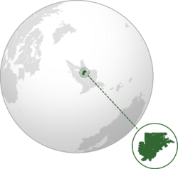
 Location of Josephinia in Elia Borealis (dark green) | |
| Capital | Halibut |
| Largest city | Port Royal |
| Official languages | Fallish |
| Recognised regional languages | Ínts’o Polhetan |
| Ethnic groups | 54.6% Native 28.5% White 9.1% Mixed 2.0% Yinese 5.8% others |
| Religion |
1.2% Tahir 4.5% others |
| Demonym(s) | Josephinian Josephine |
| Government | Unitary presidential constitutional republic |
| Lloyd Gladstone | |
| Trygve Kapal | |
| Gwen Youngkin | |
| Legislature | National Parliament |
| Independence from Falland | |
| 15 June 1759 | |
| 2 August 1776 | |
| 27 October 1884 | |
| 12 September 1889 | |
| 5 January 1893 | |
| 9 February 1977 | |
| Area | |
• Total | 101,827 km2 (39,316 sq mi) |
• Water (%) | 3.3% |
| Population | |
• December 2023 estimate | 6,395,096 |
• 2022 census | 6,378,935 (14th) |
| GDP (PPP) | 2023 estimate |
• Total | |
• Per capita | |
| GDP (nominal) | 2023 estimate |
• Total | |
• Per capita | |
| Gini (2023) | low |
| HDI (2021) | very high |
| Currency | Josephinian guilder (ƒ, JSG) |
| Time zone | UTC+4 (Eastern Elian Time, EET) |
| Date format | dd/mm/yyyy (CE) |
| Driving side | left |
| Calling code | +76 |
| Internet TLD | .js |
Josephinia, officially the Commonwealth of Josephinia (Ínts’o: 𐒿𐓂͘𐓄𐒰 𐓀𐒰͘𐓓𐒰͘ 𐓁𐒻 𐓓𐓎𐓊𐒷, hernicized: Sopʼa Mąžą Ni Žucʼe), is a sovereign state in Elia Borealis. It is bounded to the north by X, to the west and southwest by Kahneska, to the southeast by Siskiyou, and to the east by the Alconian Ocean. Its capital is Halibut while its largest city is Port Royal; other major population centers include Delamore, Gracebridge, Sequeannock, Providence, Fairview, Hamill, and Pembroke. With a population of approximately 6.3 million, it is the fifth-most and least populous country in Elia Borealis, but its most densely populated. Josephinia spans 101,827 km2 (39,316 sq mi), making it the single-smallest country on the continent and among the smallest in the Elias.
Josephinia is located on the middle section of the Elian Alconian Plain, the foothill region of the Abaroskine Mountains which crosses the country diagonally from north-west to south-east; the adjacent Big Misty Mountains form the natural boundary to Kahneska. The centrally located Golden Valley is the country's breadbasket and most fertile region. The densely populated coastal areas are dominated by drowned river valleys, fjords, and tidal marshes known as the Tidewash.
Various native Elian tribes have inhabited the territory of modern-day Josephinia for at least 11,000 years, including the Polhetan and the eastern Ama. In 1515, Fallish explorer Francis Edward Barpfylde became the first known Calesian to make landfall in the region. Subsequently, in 1608, the United Wixdon Company created the Colony of Cisylvania around the trading posts of Port Royal and Delamore as the second permanent Fallish colony in the New World after Fastings in X. Renamed in 1702, the inhabitants of now Josephinia fought for independence in the Elian Revolution of Nations in 1759 and became part of the Grand Federation in 1776.
TBD

