Sahra
Jump to navigation
Jump to search
Introduction
Kingdom Sahra | |
|---|---|
|
Flag | |
| Motto: One mountain cannot accommodate two tigers. | |
| Capital |
|
| Largest city | Ha Nihn |
| Official languages | Sahra Script |
| Recognised regional languages | Sahra Script; |
| Ethnic groups |
|
| Demonym(s) | Sahran |
| Government | Theocracy |
| Formation | |
• Proto Pharaoh period | 1150 BC |
• Sa ma khom Dynasty | 1100 BC |
• So-Rah Dynasty | 1915 AD |
• Sahradducee Period | 1950 - 2024 AD |
| Population | |
• 2024 census | 32,800,000 |
| GDP (nominal) | 2024 estimate |
• Per capita | 12,000 |
| Currency | Sahra Scrip (SRS (₴)) |
| Date format | dd/mm/yyyy |
| Driving side | right |
| Internet TLD | .Re |
This article is incomplete because it is pending further input from participants, or it is a work-in-progress by one author. Please comment on this article's talk page to share your input, comments and questions. Note: To contribute to this article, you may need to seek help from the author(s) of this page. |
Geography
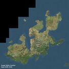
Satellite image of Orioni.
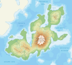
Physical map of Orioni.

River in the Mendakh Mountains.
Landscape
Arable land (16%)
Permanent crops (15%)
Permanent pastures (10%)
Forest and woodland (53%)
Other (6%)
Geographical features of Orioni
Canopy walkway in the tropical forest of Alnitak.
Mixed woodland-grassland ecosystem in Irisha.
Part of the Owara canal in Weriki.
Desert coast in western Alnilam.
Mountains of the Amilaki Wildlife Reserve in Almintaka.
Bilawa castle high in the Mendakh mountains.
Dimeti Barrier Islands in the Weledi Gulf.
River valley in Alnilam region.
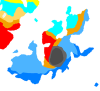
Climate
Fauna and flora
A pair of pink dolphins.
Canopy walkway in the tropical forest of Alnitak.
Vineyards along the Dayonisesi foothills.
Lake $name in summer


