Amanir
 Continents of Amanir | |
| Orbital characteristics | |
|---|---|
| 149598023 km[1] | |
| Eccentricity | 0.0167086 |
| ~365.3 days | |
| Physical characteristics | |
Mean radius | 6371.0 km[2] |
| 510072000 km2[3] | |
| Mass | 5.972 × 10^24 kg |
| 9.81 m/s2 | |
| 40270 km/h[4] | |
| Albedo | 0.367 geometric |
| Atmosphere | |
Surface pressure | 101.325 kPa |
Amanir, sometimes reffered to as simply the world — conworld[5] of the members of the Federation of Allies, a NationStates region. Lorewise, Amanir is a planet located in an unspecified star system and galaxy, possessing extrimely Earth-like qualities, including mass, gravity, size and atmosphere nearly identical to that of Earth, as well as one major moon. Amanir has wide oceans and numerous archipelagos, as well as several major continents. In contrast to Earth however, most of Amanir's landmasses are located on the southern hemisphere.
Amanir as a project combines both a priori and a posteriori elements, meaning that it is a site of both real-life languages or scripts on one side and conlangs[6], as well as constructed religions and scripts, on the other. There is no fantasy races like elves or dwarves however, unless they are purely mythological and appear in beliefs of human nations. Status of magic is as of yet unclear, with some within the region proposing a limited existence of magic and others opposing it all togather.
One of the characteristical features of Amanir is the existence of megafauna and many other relatively recently extinct species.
Name
Etymology
The name Amanir comes from Aydinirian word Amanir [ama'ɲir] and ultimately from Old Aydinirian Amanıer [ama'nʲɛr], meaning "beautiful land". It has deep connections with Jarist cosmogony, as it was supposed to be a descriptive name given by the First Cause to the world upon its creation. In Modern Aydinirian amanir as "world" is often used in poetry.
The planet has also many other names in different languages spoken at its surface.
Names in other languages
| Language | Name |
|---|---|
| Old Aydinirian | Amanıer, Hwéstar /ama'nʲɛr/, /xʷes'tar/ |
| Aydinirian | Awestar, Amanir, Firyaxar[7] /awɛs'tar/, /ama'ɲir/, /firja'ksar/ |
| Saruzh | |
| Üxa | |
World
The planet of Amanir is located in so called Goldilocks Zone, which makes Earth-like life possible and prevalent. Length of day and year is also extremely similar to that of Earth, planet possesses also a strong magnetosphere. Volcanism is a strong force on Amanir, responsible for creating many volcanic archipelagos and mountain ranges. One of the reasons for that is strong interaction between the tectonic plates and faults.
Geography
The surface of Amanir can be divided into multiple different geographic, historical or cultural regions. The popular and often used method is dividing the planet into five primary continents, with most borders between them formed by oceans and seas. Those continents are: Achara, Gwaii, Ainadestra, Nordenwald and Triuh.
Each of those continents has also other distinct regions. East from the mainland Gwaii lies a big island, called Kilaavik, which is however nearly entirely covered in glaciers. Ainadestra's eastern-most part forms the volcanic Antaran Archipelago. South of Nordenwald lies the island of Faniviace. Imatsshām, a major collection of archipelagos, forms a distinct part of Triuh. Among all of them, the most diverse however is Achara. First of all, two subcontinents are attatched via land to the main body of Achara, Solland in the east and Aydinirian Subcontinent in the north-west. Aydinirian Subcontinent is located mostly on its own tectonic plate, which extends further north, containing many of the northern archipelagos and island chains, including Kïirye, Carinian Archipelago, Grenham Isles and the Twelve Isles. Mainland Achara is often treated as a single continent partly for cultural reasons. Each of those sub-regions is often divided further.
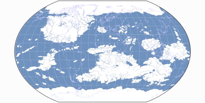
Map of Amanir with the outlines of Earth's continents as a reference, as well as the lines of longitude and latitude.
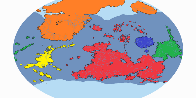
Five major continents of Amanir, although each of them consists also of other smaller regions and subcontinents.
Red: Achara, orange: Gwaii, yellow: Ainadestra, blue: Nordenwald, green: Triuh.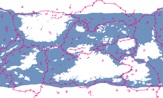
Main tectonic plates of Amanir, with tectonic faults and directions of plate movements also visible.


Climate
Large swaths of temperate climate forests and grasslands exist on Amanir, mostly on central-northern Gwaii and southern Achara, but there are also areas where ice bounds enormous territories, mostly in Gwaii and Kilaavik, but also in some southern-most parts of Achara and Ainadestra. Deserts form in the interiors of all continents, but also in other places, like eastern parts of the Aydinirian Subcontinent or southern islands of the Carinian Archipelago. The greatest deserts can be found on Achara and Gwaii and that's where the highest temperatures of the planet can be observed. Other parts of the world enjoy mostly tropical or subtropical climate, eased further by close distance to the ocean.
Several inland seas and major lakes can be found on Achara. Some of them are a result of high tectonic activity on the border between Achara Proper and Solland, others however are the remains of ancient oceans, like the Sea of X, located at the borders of Norcourt.
Some parts of Amanir are extremely mountainous, which allows the formation of mountain glaciers even in equatorial or near-equatorial areas. The highest mountain chains are located mostly on Achara, Ainadestra and Gwaii.
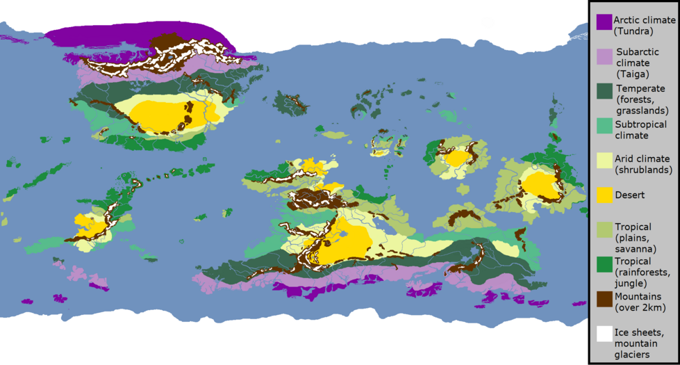
Climate map of Amanir.

Fauna and flora
Nations
Calendar
So called Standard Calendar counts years with Jashor, meaning the Fall of [Old] Aydinirian Empire, as the point of reference. Year of the destruction of the city of Djyazhoar, empire's capital, marks year 1 AD (After Destruction), alternatively 1 AJ or 1 AC (After Jashor or After Collapse). Events and years that occured before the destruction of Djyazhoar are reffered to as BD (Before Destruction), alternatively BJ or BC (Before Jashor or Before Collapse).
Other methods of counting years are or were also in use throught Amanir. Some of them include:
- Old Aydinirian Calendar