Anagonia
This article is incomplete because it is pending further input from participants, or it is a work-in-progress by one author. Please comment on this article's talk page to share your input, comments and questions. Note: To contribute to this article, you may need to seek help from the author(s) of this page. |
The Confederate States of Anagonia Anagonia | |
|---|---|
Motto: "Astra inclinant, sed nonobligant"
| |
| Capital | Liberty City |
| Largest city | Atlantica |
| Official languages | Native Anagonian & English |
| Recognised regional languages | Regional dialects dependent on State or Territory |
| Other languages | (Other European, Russian, Spanish, Other Asian, Various Non-Human Languages) |
| Ethnic groups (108 AUR) | Anagonian, Various others determined on state and territory |
| Demonym(s) | Anagonian(s), Confederate(s) |
| Government | Constitutional Republic |
• President | Mileethus Canisilus |
• Vice President | Franklin Johnson |
| Establishment | |
• XX | XX |
• XX | XX |
• XX | XX |
• XX | XX |
• XX | XX |
• XX | XX |
| Area | |
• Total | 21,864,400 km2 (8,441,900 sq mi) |
| Population | |
• 108 AUR estimate | 450,522,407 |
• Density | 5.77/km2 (14.9/sq mi) |
| GDP (nominal) | 108 AUR estimate |
• Total | D$28,424,257,741,025 |
• Per capita | D$78,246.01 |
| Gini | 0.43 low |
| HDI | 0.927 very high |
| Currency | Confederate DENAR (D$) |
| Time zone | UTC+5 (Anagonian Standard Time Zones) |
• Summer (DST) | UTC+6 (Anagonian Standard Time Zones) |
| Driving side | right |
| Calling code | 678 |
| Internet TLD | .CSA |
The Confederate States of Anagonia has:
| |
Introduction
History
Etymology
Geography and Climate
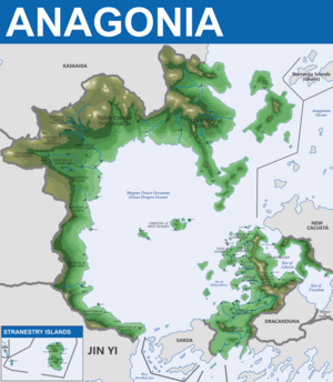
Anagonia, a vast and diverse nation spanning approximately 21,864,400 square kilometers, boasts a varied landscape characterized by rugged mountains, sweeping plains, and coastal regions. Situated southeast of the heart of the Anagonian Ocean, the nation encompasses and surrounds the magnificent Magnus Draco Oceanum, also known as the Great Dragon Ocean, which serves as the centerpiece of the nation's geography.
Geography

Image circa 108 AUR
NOTE POST-GREAT WAR CHANGES:
* More Territory to Southwest of Mainland
* Annexation of Additional Islands
* Annexation of Conquered Kaskaida Territories
Anagonia's mainland is delineated by the continents of Minor Kistavich and Major Kistavich, with the Great Dragon Ocean occupying the central expanse. The northern territories, including Ashilosa, Thetanacia, North Teustredia, South Teustredia, and Thireatheria, are dominated by mountainous terrain that gradually slopes downward into steppes, grasslands, and marshlands as they approach the Great Dragon Ocean. To the west, the Territories of Che Traman, Duderlia, Whiana, Thuaria, Arkleland, Hamotichia, and Sarder feature similar mountainous landscapes that give way to coastal plains along the shores of the Great Dragon Ocean.
In the western reaches of the nation lie the remnants of a sunken continent, now known as the West Islands, serving as a testament to ancient geological upheavals. The Stranestry Islands, located south of the Territory of Sarder in the West Arvolken Sea, offer a contrasting landscape with their gentle slopes and favorable weather conditions. To the east, mainland Anagonia transitions from the independent nation of Sarda to the Sovereign Nation of Nodea Rudav and the Imperial Drekamythian Empire, culminating in the peninsula-like mass of Anagonia proper.
The mainland of Anagonia, which is situated southeast of the Great Dragon Ocean on the continent of Minor Kistavich, is further divided into seven states: Lexington, Plymouth, Orgath, Liberty, Saratoga, Imperius, and Arkansis. The State of Saratoga and the State of Plymouth lay claim to three large islands in the Sea of Independence, providing strategic access to the Great Dragon Ocean.

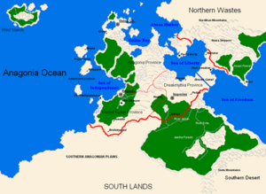
(circa United Republic era - 1921 AD & prior)
NOTE THE THREE DISTINCT PROVINCES:
* Anagonia Province
* Drekamythia Province
* Nodea Rudav Province
The United Republic of Anagonia was a more federalized entity that combined the mainland Anagonia into one primary nation. It would eventually fall due to civil war in 1921 AD.
Climate
Anagonia experiences a diverse range of climates due to its expansive geography and varied topography. The northern territories are characterized by a continental climate, with cold winters and warm summers, while the coastal regions benefit from milder temperatures moderated by oceanic influences.
In the mountainous regions, precipitation is abundant, resulting in lush forests and verdant valleys. The western territories receive ample rainfall, fostering fertile soils ideal for agriculture and supporting diverse ecosystems. In contrast, the eastern reaches of Anagonia, bordering the Imperial Drekamythian Empire and the Sovereign Nation of Nodea Rudav, experience somewhat drier conditions, with semi-arid climates prevailing in some areas. However this is diversified within the mainland of Anagonia in its primary states. They experiences a wide verity of temperate-to-dry conditions year-round which support a wide variety of agricultural and biological diversity, with mild winters typically thanks to warmer currents flowing from the north.
The coastal regions, including the Territories of Che Traman, Duderlia, Whiana, Thuaria, Arkleland, Hamotchia, and Sarder, enjoy mostly temperate climates characterized by mild winters and moderate summers. The Stranestry Islands boast favorable weather conditions year-round, making them popular destinations for tourists and travelers seeking relaxation and tranquility.
Overall, Anagonia's climate and geography contribute to its rich biodiversity and cultural diversity, making it a land of endless exploration and discovery.


