Cunenia: Difference between revisions
No edit summary |
|||
| Line 142: | Line 142: | ||
==Etymology== | ==Etymology== | ||
The name ''Cunenia'' (as well as its Afrikaans and Portuguese forms, ''Kunenië'' and ''Cunenha'' respectively) is derived from the {{wpl|Cunene River}} which flows from north to south from the Angolan highlands through the middle of the country before turning westward, where it forms the border between Cunenia and {{wpl|Namibia}} before emptying into the {{wpl|Atlantic Ocean}}. It is one of the few perennial rivers in the region, spanning a length of 1,050 kilometres (652 mi), with a drainage basin 106,560 square kilometres (41,143 sq mi) in area. The river and its surrounding area were the primary areas of Boer settlement during the {{wpl|Dorsland Trek}}. | |||
Revision as of 20:22, 17 June 2019
Republic of Cunenia Republiek van Kunenië República da Cunenha | |
|---|---|
|
Flag | |
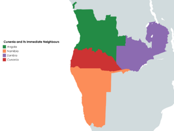
 Location of Cunenia between Angola and Namibia | |
| Status | Unrecognized state |
| Location | Middle Africa |
| Capital | Pereira d'Eça |
| Largest city | Sá da Bandeira |
| Official languages | Afrikaans |
| Recognised national languages | Portuguese |
| Recognised regional languages | Herero, Ovambo, !Kung, Khoe, RuKwangali |
| Ethnic groups | |
| Demonym(s) | Cunenian |
| Government | Parliamentary Republic |
| Pieter Strydom | |
| Hans Willem Trichardt | |
| Legislature | Volksraad |
| Independence from Angola | |
| 27 May 1874 | |
• Angolan Independence | 11 November 1975 |
| 1975 — 2002 | |
| Area | |
• Total | 223,456 km2 (86,277 sq mi) |
• Water (%) | negligible |
| Population | |
• 2014 estimate | 3,791,300 |
• Density | 16.97/km2 (44.0/sq mi) |
| Gini | 42.7 medium |
| HDI | medium |
| Currency | Pound sterling (£) (GBP) |
| Time zone | UTC+1 (WAT) |
| Driving side | right |
| Calling code | +294 |
| Internet TLD | .cnh |
Cunenia (Afrikaans: Kunenië; Portuguese: Cunenha), officially the Republic of Cunenia (Afrikaans: Republiek van Kunenië; Portuguese: República da Cunenha) is an unrecognised state and disputed territory in the southwestern part of the internationally recognised territory of Angola.
Cunenia has historically been a region of uncharacteristically high White European settlement, particularly by Afrikaners during the Dorsland Trek of the 1870s and by Portuguese settlers during the 1880s and 1890s. A large community of mixed-race people exists as well. Afrikaans is the sole official language of the country and the mother tongue of the majority of white and mixed-race people, but Portuguese is widely spoken across all ethnic groups and may be considered a secondary lingua franca.
Alarmed by the decolonisation of Africa and the prospect of majority rule at the hands of a vengeful native populace, the predominantly white government of the region of Cunenia declared the region's independence from Angola on the 11th of November, 1975 — the very same day of Angola's independence from Portugal. The area was the site of armed conflict as part of the Angolan Civil War which lasted from independence to 2002. Hostilities have ceased, but the government of Angola does not acknowledge or recognise the existence of the Republic of Cunenia as a political entity. The situation is considered to be a frozen conflict, as no formal peace has been reached despite the end of the armed conflict.
Cunenia is nominally a parliamentary republic, but in practice political franchise is limited to white and coloured citizens, and elections have been indefinitely suspended. The President, Pieter Strydom, has been in power since 1997; under his authoritarian regime, the state's various administrative and security instruments are alleged to have committed numerous human rights violations.
Etymology
The name Cunenia (as well as its Afrikaans and Portuguese forms, Kunenië and Cunenha respectively) is derived from the Cunene River which flows from north to south from the Angolan highlands through the middle of the country before turning westward, where it forms the border between Cunenia and Namibia before emptying into the Atlantic Ocean. It is one of the few perennial rivers in the region, spanning a length of 1,050 kilometres (652 mi), with a drainage basin 106,560 square kilometres (41,143 sq mi) in area. The river and its surrounding area were the primary areas of Boer settlement during the Dorsland Trek.