Ganji Islands
Jump to navigation
Jump to search
Democratic Republic of Ganji Islands República Democrática das Ilhas Cânhami (çazaprada) Reçbuwlike Democrati of Ilha Kwanjii (kwiji) | |
|---|---|
|
Flag | |
Motto: Live with ganja, family and God | |
Anthem: Dje Kwanja ov Kwanji | |
 | |
| Capital | Marley |
| Official languages | Çazaprada, Kwiji |
| Ethnic groups | 79,7 % Baji 19,3 % Bwinuengde 3 % Zakawali |
| Religion <-!-(for any ref/s to associate with religion data)--> | 46 % Christianity 24 % Rastafari |
| Demonym(s) | giji |
| Government | |
• President | Eric Kofi Khélowaki |
• Vice President | Etienne Brekowantaz |
• Prime Minister | Tuakwa Jndzo |
| Legislature | Parliament |
| Population | |
• 2017 estimate | 17,700,748 |
| GDP (PPP) | estimate |
• Total | 844,7 billion USD |
• Per capita | 47,721 |
| Gini | 8 low |
| HDI (2017) | very high |
| Currency | gawresh (ɠ) (GWR) |
| Date format | DD/MM/YYYY |
| Driving side | right |
| Calling code | +22 |
| Internet TLD | .gj |
 | |
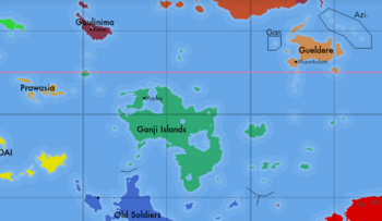
Ganji Islands, (also known as Ganji or Kwanji) is a country located in northeast Anteria. The country declared itself independent in 1744.
History
125 AD (Foundation of Ganji)
18th century (The Three Tribes)
19th century (The Trebilam crisis)
20th century (The Civil War)
21st century
Geography
Ganji is located in Northeast Anteria. Its neighbors are the Medaic Isles and Figanca.
Ganji is known for its stunning nature, the rainforests and the beautiful mountains. The highest point in Ganji is the Njembwe Mountain (2,448 m) in South Ganjiland. The main rivers are the Lokombo River and the Jabulani River. Lokombo is the main water source for the mainlanders.
The world famous Demba Rainforest is located in New Lokombo. Millions of people visit it every year, mostly from Figanca and central Anteria.
Regions
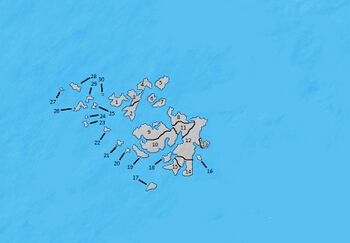
| Region Number |
Flag | Name | Capital | Population |
|---|---|---|---|---|
| 1 | Marl Island | Marley | 7,700,000 | |
| 2 | South Ganjiland | Cobewe | 800,000 | |
| 3 | North Ganjiland | New Portland | 800,000 | |
| 4 | Johnston | Çeb | 400,000 | |
| 5 | Bjawi | Limeno | 200,000 | |
| 6 | Akiwa | Twane Kebwe | 220,000 | |
| 7 | Swalale | Deschen | 180,000 | |
| 8 | Yegrentez Valin | Raiyed | 400,000 | |
| 9 | Herbington | Herbington City | 3,120,000 | |
| 10 | New Lokombo | Berhine | 240,000 | |
| 11 | Middleton | North-Amirtown | 120,000 | |
| 12 | Kewze | South-Amirtown | 160,000 | |
| 13 | Jahbi | Seatown | 280,000 | |
| 14 | Goarpaz | Mount Cabela | 56,000 | |
| 15 | Denver | Freetown | 356,000 | |
| 16 | Njab Di Zawal | Zakadilébe | 58,000 | |
| 17 | Banton Island | Buju Town | 88,000 | |
| 18 | Demaruén Island | Casedis | 48,000 | |
| 19 | Banana Island | Nebiné | 12,000 | |
| 20 | St. Kap-Vau | Kap-Vau | 400,000 | |
| 21 | St. Damién | Djewe | 140,000 | |
| 22 | Kjaw | Kszedszinhebi | 90,000 | |
| 23 | Cape Eter | Eter Town | 960,000 | |
| 24 | Kantena | Fisher | 50,000 | |
| 25 | Nevre | Nevre | 25,000 | |
| 26 | Boomerang Island | Rixton | 20,000 | |
| 27 | Gyu Na | East Bay | 38,000 | |
| 28 | Ivelze | Carlsson | 120,000 | |
| 29 | Hamilton | Fort Rajat | 200,000 | |
| 30 | Bwinuéngde | Zwinak | 6,400 |
Society
Demographics
| Population in Ganji | ||
|---|---|---|
| Year | Population | |
| 1700 | 2,195,346 | |
| 1800 | 5,065,034 | |
| 1900 | 9,217,328 | |
| 1980 | 13,980,232 | |
| 1990 | 12,445,521 | |
| 2007 | 16,259,401 | |
| 2017 | 17,700,748 | |
