Grenseverein: Difference between revisions
No edit summary |
No edit summary |
||
| Line 1: | Line 1: | ||
{{wip}} | {{wip}} | ||
{{Infobox|title = Grenseverein | {{Infobox|title = Grenseverein | ||
|image = [[File:Grenseverein.png|250px]] | |image = [[File:Grenseverein.png|250px|alt=Map of the Grenseverein]] | ||
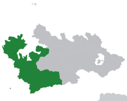
|caption = | |caption = Map of Gothis with Grenseverein member-states in green | ||
|label1 = Type | |label1 = Type | ||
|data1 = {{wpl|Open border}}s area | |data1 = {{wpl|Open border}}s area | ||
Revision as of 02:02, 31 July 2020
This article is incomplete because it is pending further input from participants, or it is a work-in-progress by one author. Please comment on this article's talk page to share your input, comments and questions. Note: To contribute to this article, you may need to seek help from the author(s) of this page. |
 Map of Gothis with Grenseverein member-states in green | |
| Type | Open borders area |
|---|---|
| Established | 2018 (between Goyanes and Gotmark) 2020 (expansion) |
| Members | |
| Area | 1,456,148 km2 (562,222 sq mi) |
| Population | TBA |
| Density | TBA |
The Grenseverein (Mercanti: border union) is an area composed of six Western Gotic nations that have an open border policy within their locality. Originally a border union with Gotmark and Goyanes, in 2020 it was extended to further include the nations of Alliaronia, Frisia, Hessunland, and Jomfruland.
Started in 2018, the Grenseverein was only limited between the Gojan nations of Goyanes and Gotmark, with the same objective as it is today. In 2020, the Goyanean government decided to expand the area after a conference in Evænning with the four aforementioned nations, carrying over the same policies to the other Gotic states.
The Grenseverein has a total land area of 1,465,148 km2 (565,697 sq mi).