List of Counties in the Obets United Republic: Difference between revisions
No edit summary |
No edit summary |
||
| Line 76: | Line 76: | ||
|1 | |1 | ||
|- | |- | ||
!scope="row"| | !scope="row"|{{flag|Kohtla-Árve}} | ||
|KÁ | |KÁ | ||
|Kohtla-Árve | |Kohtla-Árve | ||
Revision as of 16:39, 7 May 2023
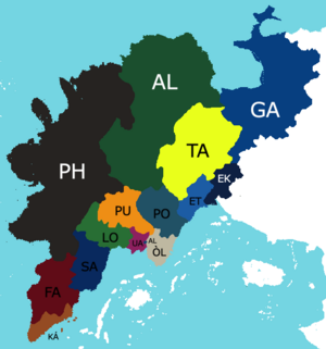
The Obets United Republic is a federal republic consisting of 15 counties, the highest level of administrative division in the Obets United Republic. Article Seven to the eObetaa Constitution delegates counties' and tribes' powers and guarantees their rights and protections under the federal government of Obets. Each county has its own constitution and government, and all counties and their residents are represented in the Eskustaheilleá, a bicameral legislature consisting of the House of Constituents and the House of Chiefs. Each county is represented by a number of representatives in the House of Constituents proportional to its population, while each county has a certain number of seats in the House of Chiefs depending on the number of tribes register in such county. The Eskustaheilleá can admit more counties, but it cannot create a new county from territory of an existing county or merge two or more counties into one without the consent of all counties involved and of the people living in those counties. Land can be transferred between two or more counties without consent of the federal government.
The largest state by population is Uralia, with a population of 2,983,024 people, while the smallest is Alatnamaa, with a population of 18,947 people; The largest state by area is Pohjanmaa, encompassing 1,443,384 square kiometers (557,294 square miles), while the smallest is Alenskè, encompassing 900 square kilometers (347 square miles). The most recent counties to be admitted, Alatnamaa and Gaamamaa, were admitted in 1977 after the Representation Act of 1975, which required all land under the Obets United Republic to be part of a county.
| Flag, name, and abbreviation | Cities | Ratification or Admission |
Population (2020 census) |
Total area | Representation | |||
|---|---|---|---|---|---|---|---|---|
| Capital | Largest | km2 | mi2 | |||||
| AT | Bruno | Gàna | 13 May, 1977 | 18,947 | 1,097,280 | 423,662 | 1 | |
| Alenskè | AL | Alenskè | 5 January, 1956 | 2,174,230 | 900 | 347 | 39 | |
| EK | Ekenas | 4 July, 1961 | 723,290 | 88,092 | 34,013 | 13 | ||
| ET | Vaara | 23 June, 1959 | 501,993 | 89,640 | 34,610 | 9 | ||
| FA | Farksi-Lahti | Hohkoma | 15 December, 1957 | 513,891 | 238,788 | 92,196 | 9 | |
| GA | Hameena | 10 May, 1977 | 78,912 | 761,400 | 293,978 | 1 | ||
| KÁ | Kohtla-Árve | Sammasko | 5 January, 1956 | 1,452,938 | 66,960 | 25,853 | 26 | |
| Lojos | LO | Lapalahti | Lojos | 5 January, 1956 | 1,029,381 | 132,192 | 51,040 | 18 |
| Òloma | ÒL | Verskoo | Òloma | 5 January, 1956 | 1,198,443 | 74,736 | 28,856 | 21 |
| Pohjanmaa | PH | Pohjanmaa | 18 July, 1970 | 195,138 | 1,443,384 | 557,294 | 3 | |
| Pohjos-Uralia | PU | Rovaniemi | Nankija | 5 January, 1956 | 1,197,765 | 162,072 | 62,576 | 21 |
| Postojna | PO | Postojna | 5 January, 1956 | 891,384 | 176,436 | 68,122 | 16 | |
| Sastekiń | SA | Sastekiń | 3 February, 1965 | 410,985 | 165,600 | 63,938 | 7 | |
| Tavastia | TA | Havasko | 5 January, 1956 | 98,940 | 499,068 | 192,691 | 2 | |
| Uralia | UA | Aalakape | 5 January, 1956 | 2,983,024 | 36,144 | 13,955 | 53 | |
