Selayar: Difference between revisions
m (anthem and motto edited) |
(added map) |
||
| Line 56: | Line 56: | ||
|calling_code = +73 | |calling_code = +73 | ||
}} | }} | ||
'''Selayar''' (/sə'laːjar/; [[Heraan language|Heraʻan]]: ''Heraʻā'' [hɛ'raʔaː]), officially the '''Monarchy of Selayar''' ([[Heraan language|Heraʻan]]: ''ʻAtāhana mi Heraʻā''), is a federal monarchy located in northern Aurelia, bordering the Mananama Bay. It is located northeast of [[Rihan]] and northwest of [[Shffahkia]]. Selayar covers LAND AREA square kilometers and has an estimated population of 41,332,005 in 2015. Selayar comprises of | '''Selayar''' (/sə'laːjar/; [[Heraan language|Heraʻan]]: ''Heraʻā'' [hɛ'raʔaː]), officially the '''Monarchy of Selayar''' ([[Heraan language|Heraʻan]]: ''ʻAtāhana mi Heraʻā''), is a federal monarchy located in northern Aurelia, bordering the Mananama Bay. It is located northeast of [[Rihan]] and northwest of [[Shffahkia]]. Selayar covers LAND AREA square kilometers and has an estimated population of 41,332,005 in 2015. Selayar comprises of 7 ''ʻArana'' (state-kingdom), 1 Federal City, and 1 Royal Capital City. Wanavera'a, officially the Royal Capital City of Wanavera'a, is the capital, while Mawura is the largest city in Selayar. | ||
Selayar is one of the most diverse countries on Eurth, owing to its location in the tropics. It's year-round hot and humid temperature along with its dense cover of untouched forests provide habitats for a large number of endemic species. The fertile floodplain on the north supports a dense and bustling population of Selayar, with many rivers flowing through from the Wananga mountains in the east. The floodplain alone hosts an almost three-fourth population of the nation. | Selayar is one of the most diverse countries on Eurth, owing to its location in the tropics. It's year-round hot and humid temperature along with its dense cover of untouched forests provide habitats for a large number of endemic species. The fertile floodplain on the north supports a dense and bustling population of Selayar, with many rivers flowing through from the Wananga mountains in the east. The floodplain alone hosts an almost three-fourth population of the nation. | ||
| Line 81: | Line 81: | ||
==Geography== | ==Geography== | ||
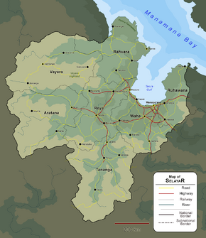
[[File:Geographic Map of Selayar.png|290px|thumb|Geographic map of Selayar]] | |||
==Government== | ==Government== | ||
Revision as of 08:51, 30 July 2019
This article is incomplete because it is pending further input from participants, or it is a work-in-progress by one author. Please comment on this article's talk page to share your input, comments and questions. Note: To contribute to this article, you may need to seek help from the author(s) of this page. |
The Monarchy of Selayar ʻAtāhana mi Heraʻā (Heraʻa) | |
|---|---|
|
Flag | |
Motto: Rimamura Wavanga "Prosperous Land" | |
Anthem: Risutiva mu Heraʻā "Long Live Selayar" | |
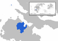
 Area controlled by Selayar shown in blue | |
| Status | Independent State |
| Capital | Wanaveraʻa |
| Largest city | Mawura |
| Official languages | Heraʻan |
| Recognised regional languages | Reyan, Tanganan, and Torangan |
| Demonym(s) | Selayari |
| Government | Federal parliamentary elective constitutional monarchy |
• Monarch | Manu Wesa II |
• Prime Minister | Huti Manaranga |
| Legislature | Varai mi Tama |
| Formation | |
| 1614 | |
• Treaty of Terata | 14 May 1703 |
• Siege of Wanaveraʻa | 9 December 1855 |
• 18 August Revolution | 18 August 1897 |
• Treaty of ʻArama | 1 December 1974 |
| Population | |
• 2015 census | 41,332,005 |
| GDP (nominal) | estimate |
• Total | $867 million |
• Per capita | $20,988 |
| Gini (2017) | 43.2 medium |
| HDI (2017) | .717 high |
| Currency | Nanari (SLN) |
| Time zone | IST -6 |
| Date format | dd/mm/yyyy |
| Driving side | left |
| Calling code | +73 |
| Internet TLD | .sl |
Selayar (/sə'laːjar/; Heraʻan: Heraʻā [hɛ'raʔaː]), officially the Monarchy of Selayar (Heraʻan: ʻAtāhana mi Heraʻā), is a federal monarchy located in northern Aurelia, bordering the Mananama Bay. It is located northeast of Rihan and northwest of Shffahkia. Selayar covers LAND AREA square kilometers and has an estimated population of 41,332,005 in 2015. Selayar comprises of 7 ʻArana (state-kingdom), 1 Federal City, and 1 Royal Capital City. Wanavera'a, officially the Royal Capital City of Wanavera'a, is the capital, while Mawura is the largest city in Selayar.
Selayar is one of the most diverse countries on Eurth, owing to its location in the tropics. It's year-round hot and humid temperature along with its dense cover of untouched forests provide habitats for a large number of endemic species. The fertile floodplain on the north supports a dense and bustling population of Selayar, with many rivers flowing through from the Wananga mountains in the east. The floodplain alone hosts an almost three-fourth population of the nation.
The floodplain has always been central to the history of Selayar, due to its role as a major food production centre in the region. The rise of Reyan Empire in the 17th century was inextricably linked with the conquest of the floodplain itself. Having secured its food supplies back home, the empire went on an expansionist policy, conquering its neighbour one by one, and finally reaching its height in the early 18th century with the unification of almost all of the Heraʻaic monarchies. The anomalous dry period that followed brought down the empire with it, creating a vacuum of power that was exploited by its successor, the monarchy of Selayar. In the following century, the monarchy gradually opened itself to foreign influences, which partly precipitated the 18 August Revolution that limited the monarch's power, essentially turning the monarchy to a constitutional monarchy that lasted until modern day.
Etymology
The floodplain where the majority of Selayar population live in is known as Heraʻa in Selayaric and it is from this that the name "Selayar" is derived. The name "Selayar" emerged from the first contact with Shffahkia, who transcribed Heraʻa as Saraia, and in turn spread to various languages across Eurth, ultimately leading to the modern name Selayar. Alternative spelling may still be used in some nations. Salajar, Sleyar, Saraya are one of the few examples in various languages.
The native name for Selayar is Heraʻa, believed to be comprised of two words, Hara and Aʻa, which means fertility and settled respectively. Thus it roughly translates to 'fertile land that has been settled'. The name originally referred to the floodplain in the central and north part of modern Selayar, but in time this has morphed to refer to the nation as a whole in tandem with the name "Selayar".
History
Prehistoric
Rise of the Reyan Empire
Heraʻa Domination
The Enlightenment
Time of Crises
Haravatu Era
Geography
Government
Selayar is a federal parliamentary elective constitutional monarchy.
Province level
Administrative Divisions
Selayar consists of 6 ʻArana (equivalent to province), 1 Federal City, and 1 Royal Capital City.
Economy
Selayari economy has been dubbed as the fastest growing in the region, its GDP has doubled since the civil war ended in 2014. The economic condition has improved over the years. Many new oil fields have operated, and many new concessions are ready to be operated. The steady rise of oil price has helped propped up Selayari economy in many ways, and petroleum-related products make up to 90% of the Selayari exports. Unemployment, however, is still pervasive in Selayar along with poverty level. Unemployment level reached a record high in 2015, almost 25%, due to the repatriation of many civil war soldiers and about 45% of the Selayari population is below the poverty line. Inflation has been kept steady, and reach a record low in 2016. Officially Selayari practised a socialist system. Some sectors that involved people's welfare are by constitution be owned entirely by the government. This includes electricity, waters distribution, transportation system and oil fields. Private companies aren't banned, and all Selayari is free to make his own company. Though by law, the government needs to own the majority of the companies' shares. In turn, the government will subsidise most of the companies expenditure. Only Selayari could own a company, although exemption could be made that foreign companies could own up to 49% of state-designated company's shares. In most case, foreign companies needed to cooperate with native Selayari to set up their branch in Selayar with government supervision.
The tax rate is progressive, with people that have less than $4000 income per year exempted entirely from paying tax. It reached almost 40% for people who have income more than $1,000,000 per year. Foreign nationals are exempted entirely from tax, but it needs to pay "foreign national tax" for about $1000 per month. Companies are also exempted from tax because almost, if not all, companies are owned by the government.
Historically, Selayari economy has always been propped up by spice trading and fishery. It has been famous for its spice that only grows in Selayari islands, the Butternut, and the source of many other exotic spices. During the 19th century, COLONISER applied 'forced plantation' system and exploit Selayari to only produce many exotic spices. This lead to the unproductivity of many Selayari soils later on due to monoculture and extreme use of fertilisers. Nowadays, the agriculture sector of Selayari contributes a little to the economy due to the already-little productive lands being destroyed as a result of 50-years long civil war. Fishery still contributed much to the country's economy, and was the major backbone of Selayari economy and remained the only effective sector throughout the civil war. Its importance has been dwarfed by rising oil sector, however.
Oil was first found in the location of future Liaknia in 1935, though it could only be extracted in 1941 due to the oil-driven 1938 coup. Selayari oil production gained importance in the WAR, being the only neutral major oil producing nation in the region. In this period fishery and agriculture still contributed a lot to the Selayari economy. The start of Selayari Civil War in 1967 was precipitated by oil dispute in western Selayari, and it devastated most of Selayari infrastructure, plunging it deep recession period.
1 dollar is equal to 1,200 nanaka.
Demography
Cities
Largest cities or towns in Selayar
2018 census | |||||||||
|---|---|---|---|---|---|---|---|---|---|
| Rank | ʻArana | Pop. | Rank | ʻArana | Pop. | ||||
| 1 | Mawura | Federal city | 2,968,564 | 11 | Tirova | Tananga | 481,446 | ||
| 2 | Wanaveraʻa | Federal city | 1,857,511 | 12 | Taʻa | Aratana | 430,662 | ||
| 3 | Ruwara | Waha | 1,310,673 | 13 | Taruma | Rahuara | 419,311 | ||
| 4 | Terata | Reya | 1,148,375 | 14 | Keorama | Aratana | 394,340 | ||
| 5 | Vanaʻa | Tananga | 937,114 | 15 | Wanataha | Aratana | 368,122 | ||
| 6 | Roroima | Reya | 750,450 | 16 | Wentanga | Vayara | 355,105 | ||
| 7 | Wahina | Ruhawana | 680,245 | 17 | ʻArama | Rahuara | 302,439 | ||
| 8 | Watesa | Ruhawana | 612,398 | 18 | Hiraʻuma | Vayara | 287,556 | ||
| 9 | Weruwanga | Reya | 523,964 | 19 | ʻAranga | Ruhawana | 280,834 | ||
| 10 | Raomi | Waha | 504,387 | 20 | Aʻaranga | Rahuara | 252,494 | ||
Culture
This template may be deleted.

