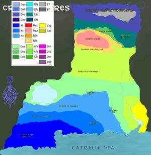
Geography of Crystal Spires
Crystal Spires is made up of two large landmasses. D'hɑlbrisir and Vinyelaujor. D'hɑlbrisir stretches some 2,500,000 km across South Central Mystria in landmass and 725,711 km of Sea Territories. It is bordered by seas and waters Southward, with the Catralia and Talabrath seas, and is bordered by landmasses on its 3 other sides, with High Treefolk to the West, Fenris to the North, the Underworld of Terradin to the Far Northeast, the Orderite Territories to the North East, Cantalvia to the East along with Carceno, Mystrian Altea in the South East. Across the Talabrath is Yesopalitha.
Vinyelaujor spreads across the Eastern Southern Pony Lands. It is bordered to the northeast by the country of Yorobia, to the north by the Kingdom of Peace, to the Northwest by Krumbia, and Enatai, and to the West by the Sea of Azohaarah, and the Sanian Confederacy, and to the south by Terra Nullius, and to the East by Al Harakut Al Islami, Lanos, and Adun and the Melvidir sea.
D'hɑlbrisir has been divided into seven physical macro-regions: The Northern Highlands (subdivided into the Fornt's Crown Mountains, the Marvolian Highlands, and the Hebren valley), The Sandsea (Subdivided into the Zanjing Loess Plateau, the Fryhete Desert, and the Pazine Oasis), The Silent Woods of Caldurim, The Narai River Valley, The Lowlands, The Faerin Valdur Wood, The Majstaad. Its physical features are multiples. The river valley has fertile lowlands and foothills with most of the agricultural output and human populations. The western and northern section is a region of sunken drainage basins, deserts, and rolling plateaus, and towering massifs, including a portion of the highest tableland in Mystria (Fornt's Crown) and with lower agricultural possibilities and thus, far less populated.
Vinyelaujor is made up of four physical macro regions. The Coastal section of Vihara, the Vale, the Rivergate, and the Ridgelands. The Vale makes up the majority of the fertile lands in Vinyelaujor, the Ridgelands lead to the foothills where much of the lands are used for expansion. The Rivergate is also a fertile valley cascading through the edge of the vale and to the bottom of the colony.
Traditionally, the Spirean population centered around the River Valleys and Lakes orienting itself toward its own enormous inland market, developing as an imperial power whose center laid in the middle and upper reaches of the Narai River on the north Luminas plains. More recently, the 535 kilometer coastline has been used extensively for export-oriented trade, marking a power shift, with the coastline provinces slowly becoming the leading economic centers.
With an area of about 2.5 Million km², it is very similar to Tibet in Landmass and 725,711km² of Sea Mass approximately the size of the Zambia. This figure is sometimes challenged by border disputes, most notably by Altea and the Orderites from Kalron.
Physical geography
Topography
Generalities
The topography of Crystal Spires has been divided by the government into Twelve physical macro-regions, namely The Northern Highlands (subdivided into the Fornt's Crown Mountains, the Marvolian Highlands, and the Hebren valley), The Sandsea (Subdivided into the Zanjing Loess Plateau, the Fryhete Desert, and the Pazine Oasis), The Silent Woods of Caldurim, The Narai River Valley, The Lowlands, The Faerin Valdur Wood, The Majstaad and the Submerged Lands in D'hɑlbrisir; then there is Vihara, the Vale, the Rivergate, and the Ridgelands in Vinyelaujor. It is diverse with snow-capped mountains, deep river valleys, broad basins, high plateaus, rolling plains, terraced hills, sandy dunes, craggy karsts, volcanic calderas, low-latitude glaciers and other landforms present in myriad variations. In general, the land in D'hɑlbrisir is high in the North and descends to the southern coast. Mountains, plateaus, Forests and hills account for nearly 60% of the country's land surface. Most of the country's arable land and population are based in lowland plains, lake and river basins, though some of the greatest basins are filled with deserts. The country's rugged terrain presents problems for the construction of overland transportation infrastructure and requires extensive terracing to sustain agriculture, but are conducive to the development of forestry, mineral and hydropower resources and tourism. Vinyelaujor in contrast has a northern coast and a western coast, but more basins and flat lands than the hilly D'hɑlbrisir.
D'hɑlbrisir's Macro Regions
The Northern Highlands
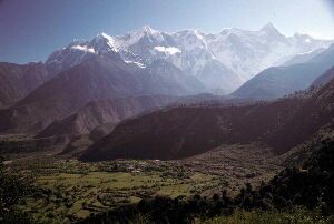
Some of Mystria's tallest mountains, the Fornt's Crown, the Marvolian Highlands and Kyleri divide the Section of the Hebren valley from most of Crystal Spires. Eleven of the 17 tallest mountain peaks are located on Crystal Spire's Northern borders. They include tallest peak of Crystal Spires Mt. Kultika (8,000m) in the Cusp on the border with Fenris and the world's second tallest peak, Vestrim (7,902m) on the border with Orderite dominated Altea. From these towering heights in the North, the land descends in steps like a terrace. South of the Crown and east of the Sandsea is the vast Marvolian Highland, the largest and highest plateau in Crystal Spires, The plateau has an average elevation of 3,000m above sea level and covers an area of 9,381 square kilometers. West of the Fornt's crown and North of the Sandsea is the Western Foothills which are deeply folded mountains which fan out toward the Basin of the Sandsea, which is ringed by mountains in 1,000-3,000m elevation. It is known for limestone karst landscapes.
The Sandsea
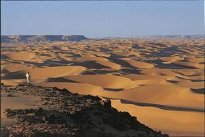
Southwest of the Fornt's Crown Mountains, between the northern slope of Lirane and southern slope of Verim, is the vast Basin of the Sandsea, which contains the Fryhete Desert. The Sandsea is enormous and measures 129,702 sq km. Average elevation in the basin is 1,000m. To the east, the basin ascends into the Marvolian Highlands, and in the deepest area of the Sandsea is where the dried lake bed of Lake Vormal is at -9 m below sea level, is the second lowest surface point in Crystal Spires. With temperatures that have reached 41.2 C, the lake bed ranks as one the hottest places in Crystal Spires. The ergs flow like a massive lake of sand. North of the Caldurim is the Zanjing Loess Plateau. The plateau is 1,000-1,500m in elevation and is filled with loess, a yellowish, loose soil that travels easily in the wind. It has a narrow basin running north to south along the Yig River which runs through the area which marks the Pazine Oasis near Fordur.
The Silent Woods of Caldurim
The forests of Caldurim are one of the largest unspoiled woodlands in Crystal Spires. The wooded area has average elevation of 1,000-500m and it is rolling and hilly lands with dense foliage. The area is not a basin nor is it flat, and has several tributaries and streams running through the area. The Woods are said to be 'silent' only due to the lack of habitation there. Aether Levels in the area are said to be unusually high and Spireans are said to become lost in the woods, where they go missing for years and many are presumed dead. The survivors that return after becoming lost end up returning with severe psychological damage, leading many to believe the wood drives them mad. Others merely disappear without a trace.
The Narai River Valley
The Narai River is the Principal River in Crystal Spires, and is long and slender, fast flowing with tremendous depth. Because the river level drops precipitously toward the Majstaad, it continues a sluggish course across the delta, transports a heavy load of sand and mud from the upper reaches, much of which is deposited on the flat Luminas plain. The flow is channeled mainly by constantly repaired man-made embankments; as a result the river flows on a raised ridge fifty meters or more above the plain, and waterlogging, floods, and course changes have recurred over the centuries. Traditionally, rulers were judged by their concern for or indifference to preservation of the embankments, and the Narai River Valley is considered one of the most populous in the Spires historically.
The Lowlands
The Lowlands are an Endorheic depression which contain a number of intermittent (seasonal) lakes and persistent wetlands which are called Fallhelm. The Lowlands also contain the wetlands and the Exoheric lake of Azohuorah. The Scarfell Valley is the lowest existing part of Crystal Spires, mostly considered as part of the lowlands. The Valley itself has one of the largest constructed Canyons in the Continent which originally was to control the Starfell Tear which poured the monster migrations and more recently megafauna.
The Faerin Valdur Wood
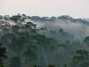
Faerin Valdur is an expansive tropical rainforest climate in the region and also descends to meet the coast. A very unique feature of the wood is the 'living wood' in which the foliage changes color with light polarization to communicate to one another and animals are heavily reliant on adaptive camouflage. This is said to be due to aether being absorbed through the trees at a higher rate mirroring the terrible Caldurim Forest, but to different effect. The Faerin Valdur reaches the seas with a sandy coast.
The Majstaad
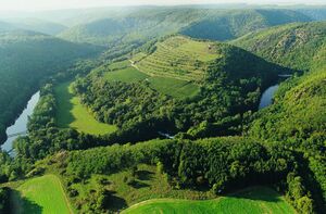
The Majstaad makes up a tributary landscape of streams, limestone karsts, and flat plains to the West. The Majstaad is a traditional deposit of fertile silt, and unlike the upper reaches of the Narai where it is fast flowing from the elevation drops it is slow and meandering to the coast. The Elevation Averages are between 500m above sea level to 5m below sea level.
The Submerged Lands
The submerged lands make up the Abyssal plains, the Talabrath Ridges, the Arthiam Plateau, and the Mystaran Plains beneath the Catralia and Talabrath seas. The Ridges have an average depth of 3,000 meters below sea level, and the plains have an average depth of 6,000 meters below sea level. The plateau has average depths of 2,000 meters below sea level.
Vinyelaujor's Macro Regions
The Vale
The Vale is historically the heart of Vinyelaujor, with the many lakes and streams, it was historically easy for the earth ponies, deer, and sheep to reap the benefits of the lands. The vale had fairly little problem with cultivation, and is thus one of the most populous macro regions. It is temperate with warm summers and cool winters. It is well known for its vast farmlands and large fields and orchards.
Vihara
Vihara is known as a sacred lands which lead to the Northwestern coast. There are steppes and grassland plains which lead to the ocean. The Western area is much more arid and hostile which is where more buffalo, sheep and deer call their home.
The Rivergate
The Rivergate is the location where the Triass river passes through to reach the Azhaarah Sea. The Triass river pushes through the fields and hill lands. The River gate itself opens up a canyon where more fertile lands with a basin leading to the ridgelands.
The Ridgelands
The Ridgelands are an inclined hillands hostile to farming and is instead concentrated upon for mining and expansion through the forbidding Himmaneghan mountains and southwards into the no-man's land wastes of the Badlands.
Mountain Peaks
Aside from Kultika which reaches 8,000m and Vestrim, 7,902m there are about 17 enormous peaks on Crystal Spires's Northern borders which has heights over 7,000m high. Yokta reaches 7564m, Luame 7451m, Mirie 7384m, Glauve 7252m. On the border with Kalron and Fenris 7080m, Broad Peak 7051m, Gallenhood 7035m, Netherhall 6946m, and Lirane 6932m of the border with High Treefolk. The tallest peak entirely within Crystal Spires is Kultika 8,000m of the Fornt's Crown in Kronas beyond Mephiste. In all, 9 of the 14 mountain peaks in the country over 7,000m are in or on the border of Crystal Spires. Another notable peak in Crystal Spires is Oyelia's Tear 2450m, near the ruins of Tabril in the Chancellery of Valur.
Rivers and drainage
Generalities
Crystal Spires has several rivers, tributaries, streams, and deltas. The majority of rivers flow North to South cascading and emptying into the Catralia and Talabrath Seas. The Principle river is the Narai which is long, fast flowing, and deep. It rises and cascades from the Marvolian Highlands and flows through East Spires before entering the Talabrath near Rulkdjetaasha. The Yig falls 6,300m from the Fornt's Crown through the Paizene Oasis into the Caldurim. The Yirven river feeds into Azohuorah, an Endoheric Lake which also flows into many of the small wetlands of Fallhelm.
Inland drainage involves a number of upland basins in the west central Spires which accounts for about 40 percent of the country's total drainage area. Many rivers and streams flow into lakes in the lowlands or diminish in the desert. They are very useful for irrigation. Talabrath and Catralia seas make up the Spirean Coastlands. More than half the coastline (predominantly in the East) is rocky and craggy due to large eroded limestone worn away by the Narai River and heavy rainfall which has worn caves into the rock and karst hill lands; while the remainder is sandy with peach volcanic sand beneath the limestone.
River Plains
The Narai River Valley is complex because the Narai river level drops precipitously toward the North Luminas Plain, where it splits off into the Shorai and Narai River, and then divides ever further into the Reishile Rivers continuing a sluggish course across the valley to the south of the country, it transports a heavy load of sand and mud from the upper reaches, much of which is deposited on the flat plain. The flow is channeled mainly by constantly repaired constructed embankments; as a result the rivers flows on a raised ridge fifty meters or more above the plain, and waterlogging, floods, and course changes have recurred over the centuries. Traditionally, rulers were judged by their concern for or indifference to preservation of the embankments. In the modern era, Crystal Spires has undertaken extensive flood control and conservation measures along the Luminas River Valley.
Then there are the Stone Born Rivers Flowing from its source in the Western Foothills, the Yig river courses toward the desert where the altitude drops into the Paizene Oasis, depositing silt into the Fordurian valley and Shaltric before draining into the Reyarkle Delta. Spirean people have farmed the richer alluvial soils of the plains since ancient times, constructing the Canals for north-south transport Like other densely populated areas of Crystal Spires, the plains are subject not only to floods but to earthquakes. The Silent Rivers are nigh unexploited rivers which are often left untouched. They are deep and course through the Silent Woods of Caldurim. Their course is estimated to have about seven main tributaries whose position is said to shift. The Rivers of the Majstaad also flow South and mineral rich. They course through the limestone heavy ground and leave many karsts and caves in the environment, ending up in the basin of the plains. The Atawara River and the Pikal Rivers are the Principle Rivers of the Southwestern region crossing through the Faerin Valdur, and the other depositing mineral rich soil in the farming heavy regions of the south.
Geology and natural resources
There is plentiful limestone in the Spires, thorium, antimony, natural graphite, tungsten, and zinc. Other major minerals are aluminum, bauxite, crude petroleum, diamonds, gold, iron ore, lead, magnetite, manganese, mercury, molybdenum, natural gas, phosphate rock, tin, vanadium, adamantium, khyber, mithril, Nenya's ember, runestone, and orichalcon found in deep caves and mountains.
Biology
Land use
Crystal Spires has, based on 2012 estimates, 19.86% Arable Land, but only 1.3% is used for permanent crops. The rest has been unplanted or have temporary crops. With comparatively little land planted to permanent crops, intensive agricultural techniques are used to reap harvests that are sufficient to feed the population and still have surplus for export.
Wildlife
The Spirean Ecozone is one of the most megadiverse in Mystria. In the Northern zone, animals such as the horse, dragon, ogre, gorgon, camel, tapir, cyclops, sandwyrm, and jerboa can be found. In the Southern Regions the Leopard Cat, Basilisk, Cockatrice, Swamp Monster, Fleshcrawler, Panda, bamboo rat, treeshrew, and various monkey and ape species exist. Some overlap exists between the two regions due to natural dispersal and migration; deer, wyverns, antelope, goats, bears, griffons, wolves, wild boars, snakes, lizards, and numerous rodent species can all be found in Crystal Spires's diverse climatic and geological environment. The famous Phoenix is found only in a limited area along the Narai River. Crystal Spires suffers from a continuing problem with hostile and terrifying predation by large predators in the area, but Government takes many steps to limit hostile animal attacks which have become limited in the Post Nefreedian war.
Crystal Spires also hosts a variety of forest types. Cold coniferous forests predominate in the north of the country, supporting animal species such as moose and the black bugbear, along with over 120 bird species. Moist conifer forests can have thickets of bamboo as an understory, replaced by rhododendrons in higher montane stands of juniper and yew. Subtropical forests, which dominate central and some of southern Spires, support as many as 146,000 species of flora. There are tropical and seasonal rainforests in the Courlie, Lukan, Mulier, and Valiste Chancelleries; wetlands in the Helian Chancellery; full grassland plains and steppes in Manu and South Valur; Subtropical forests dominate central spires and much of the Narai River Valley and Deltas.
Geography of Peoples
History
Spirean history is often explained in terms of several strategic areas, definite by particular topographic limits. Starting from the Luminas central plain, the former heart of the Northern Rider populations, who expanded militarily and then demographically toward the Loess plateau, the Sandsea, and the Southern hills,and not without resistance from local populations. Pushed by its comparatively higher demographic growth, the Beastlings continued their expansion by military and demographic waves. The far-south of Crystal Spires, in Majstaad was first reached and durably subdued by the Riders's armies. The Lowlands became strongly integrated into the Imperial empire during the late Rethil dynasty, while the West side of the Fornt's Crown mountains, formerly the home of Nayali and Meilian tribes were subdued. The Tributary system with Altea allowed the Lowlands to be a source of the bipolar dichotomy between the Northern Riders and the Southern Cities.
Demographic geography
The Spirean demographic occupation follows the topography and availability of arable lands and former arable lands.
Economic geography
Crystal Spires's economic system has only recently become export-oriented. Historically it was subsistence oriented which centered Crystal Spirean power in the Lowland Basins, Oases, and River Valleys. The coastal provinces got the highest benefice for the recent development of Spirean economy and aid, and has become the new economic center of Crystal Spires. The Spirean leadership have long encouraged for a move inland, and in 2012, following the crisis, the top brass announced a policy to redirect Spirean production toward the national market which may cause another shift in economic geography.
Transportation
Most transportation is on the Southern side up the Narai River. Efforts have been made to transport raw materials from the rest of the world and from the mineral-rich north to the Spirean river valleys.
Administrative geography
Spirean administrative geography was drawn mainly during the 1986 and 1987 administrative reorganizations. These reorganizations have been the source of much debate within Crystal Spires and tends to draw a lot of ire.
Boundary disputes
There are several border disputes which exist in Crystal Spires, the foremost being Altea and Kalron's claims to the Spirean frontier on the Narai river valley, and then there is the Spirean claim of Carcenoan land in old Arden and Cooran which has since been annexed by Carcenese in the old disputes during the Time of Sorrows.
Atmosphere and pollution
Climate
Crystal Spire's landscapes vary significantly across its vast land area. In the South, along the shores the Talabrath Sea, there are extensive and densely populated alluvial plains, while on the Catralia Sea there are Tropical and Subtropical forests while on the edges of the north is dominated by hills and high mountain ranges. The while the southeast hosts the deltas of Crystal Spire's major river, the Narai River. To the west there are major forests and the lake of Azohuorah, an exoheric lake in the West Central Spires, and in the northwest section south of the Fornt's Crown are the more arid landscapes of the Fryhet Desert. The highest point, Mt. Kultika (8,000 m)is on the Northeast border. The country's lowest point is in the Scarfell Valley (-10 m).
A major environmental issue in Crystal Spires is the continued expansion of its deserts, particularly the Fryhet Desert. Although barrier tree lines planted since the 1980s have reduced the frequency of sandstorms, prolonged drought and poor agricultural practices have resulted in dust storms plaguing Fordur and Shaltric each spring, which then spread to other parts of Crystal Spires. According to environmental watchdogs, Spires is losing an alarming amount of acres per year to desertification and deforestation has become common which leads to erosion. Water quality, erosion, and pollution control have become important issues in Crystal Spires relations with other countries, and melting glaciers in the Fornt's Crown could potentially lead to water shortages for millions of people.
Crystal Spire's climate is mainly dominated by dry seasons and wet monsoons, which lead to a pronounced temperature differences between winter and summer. In the winter, northern winds coming from high-latitude areas are cold and dry; in summer, southern winds from coastal areas at lower latitudes are warm and moist. The climate in Crystal Spires differs from region to region because of the country's extensive and complex topography. Crystal Spires experiences frequent typhoons (about five per year along southern and eastern coasts), earthquakes, damaging floods, mudslides, monsoons, tsunamis, dust and sand storms, ethereal disruptions,and droughts.
Environment
Air pollution (sulfur dioxide particulates) from reliance on coal is a major issue in the North, along with water pollution from untreated wastes and runoff from agriculture, and use of debated standards of pollutant concentration rather than Total Maximum Daily Load have caused trouble in the Spires. There are water shortages, particularly in the north west. The eastern part of Crystal Spires on occasion experiences smoke and dense fog in the atmosphere as a result of industrial pollution. Heavy deforestation with an estimated loss of one-fifth of agricultural land since 1949 to soil erosion and economic development is occurring with resulting desertification. The size of the Fryhete desert has increased and now is becoming a major concern to Fordurians who have begun major environmental reform and are leaders in the region.

