Marovoay (Island)
Jump to navigation
Jump to search
| Native name: Marovoa | |
|---|---|
 | |
| Geography | |
| Location | Gulf of Lissaq, Allhavn Ocean |
| Archipelago | Marovoanise Archipelago |
| Adjacent bodies of water | Allhavn Ocean, Gulf of Lissaq, Straits of Sypkens, Allessian Gap |
| Total islands | 1 |
| Major islands | Marovoay |
| Area | 200,333.24 km2 (77,349.10 sq mi) |
| Area rank | 6 |
| Length | 1,015.37 km (630.922 mi) |
| Width | 945.97 km (587.799 mi) |
| Highest elevation | 2,798 m (9,180 ft) |
| Highest point | Ambohitra |
| Administration | |
Marovoay | |
| Provinces | Amboina, Arihompy, Ihosy, Likata, Mahatako Sitamstsetra, Tranotirano, Tsarafotsy, Varidandy, Vohirara |
| Special Administrative Divisions | Ambanhina, Toliara |
| Capital and largest City | Toliara |
| President | Tsiory Razafimahaleo |
| Demographics | |
| Demonym | Marovoanise |
| Population | 11,690,860 (2013) |
| Pop. density | 58.357 /km2 (151.144 /sq mi) |
| Languages | Marovoanise, Allessian |
| Additional information | |
| Time zone |
|
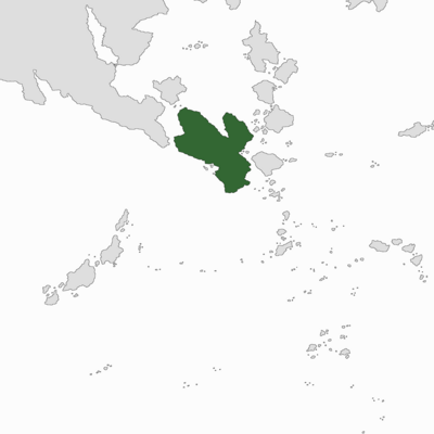
Marovoay, also known as Marovoay, is the central island of Marovoay. One of the four Greater Marovoanise Islands, and the world's 6th-largest island, it is situated east of the Allessian Peninsula, west of the Ijsselsee Chain, and south of the Ardentian Mainland. Within Marovoay, no island is larger or more populous.
The landmass of Marovoay includes two peninsulas: the eastern Vindara Arm and the Tomini Peninsula. The Bay of Katra is the densest populated area of Marovoay, and is the site of the capital, Toliara and the Bay Islands. The Strait of Allessia runs along the western side of the island and separates the island from Allessia.