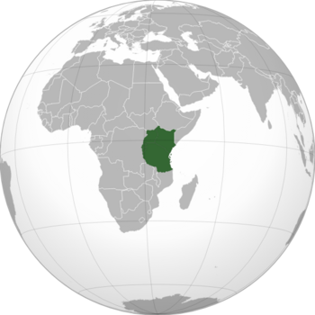
Ngorobi
Plurinational Republic of Ngorobi Jamhuri ya wingi ya Ngorobi (Swahili) Repubulika ya benshi ya Ngorobi (Kinyarwanda) République Plurinational de Ngorobi (French) | |
|---|---|
|
Flag | |
 | |
| Capital and Largest city | Mombaralal |
| Official languages | Swahili French English |
| Recognised national languages | Kinyarwanda Arabic |
| Recognised regional languages | Over 100 minority languages |
| Demonym(s) | Ngorobian |
| Government | Federal presidential republic |
• President | Julian Majuma |
| Population | |
• 2022 census | 188,281,110 |
| GDP (nominal) | estimate |
• Total | $253.3 billion |
| Gini | 41.2 medium |
| HDI | low |
| Currency | Shilling (NSH) |
| Time zone | UTC+3 |
Ngorobi officially the Plurinational Republic of Ngorobi is a country located in East Africa, renowned as one of the largest in the continent and the seventh most populated in the world, punitive income tax rates, stringent health and safety legislation and enforcement of compulsory male shirtlessness. The government type is defined as plurinational due to the presence of many different cultures, languages and religions all of them co-existing in absolute harmony.
Ngorobians enjoy great individual freedoms in everything except elections, which, where they exist at all, are populist shams for a dictatorship government that has no intention of ever giving up power.
The fair efficient Ngorobian economy worth a remarkable 1,678 trillion Shillings a year, is broadly diversified and is driven entirely by a combination of government and state-owned industry. The main industries are beef-based agriculture, trout fishing and uranium mining.
The presence of the savanna makes Ngorobi a good destination for making safari and enjoy the sight of wild animals. It also shelters the highest peak of Africa, the Mount Kilimantaro.
Geography
Climate
| Climate data for Mombaralal, Ngorobi | |||||||||||||
|---|---|---|---|---|---|---|---|---|---|---|---|---|---|
| Month | Jan | Feb | Mar | Apr | May | Jun | Jul | Aug | Sep | Oct | Nov | Dec | Year |
| Average high °C (°F) | 31.7 (89.1) |
31.9 (89.4) |
32.9 (91.2) |
33.8 (92.8) |
34.5 (94.1) |
34.3 (93.7) |
33.9 (93.0) |
33.9 (93.0) |
33.5 (92.3) |
32.5 (90.5) |
32.2 (90.0) |
31.7 (89.1) |
33.1 (91.5) |
| Average low °C (°F) | 20.4 (68.7) |
20.4 (68.7) |
20.6 (69.1) |
21.0 (69.8) |
21.0 (69.8) |
21.3 (70.3) |
21.2 (70.2) |
21.1 (70.0) |
21.1 (70.0) |
21.1 (70.0) |
21.0 (69.8) |
20.5 (68.9) |
20.9 (69.6) |
| Average precipitation mm (inches) | 73.6 (2.90) |
90.4 (3.56) |
140.8 (5.54) |
368.8 (14.52) |
173.7 (6.84) |
125.5 (4.94) |
111.2 (4.38) |
103.4 (4.07) |
95.9 (3.78) |
83.9 (3.30) |
66.6 (2.62) |
61.4 (2.42) |
1,495.2 (58.87) |
| Month | Jan | Feb | Mar | Apr | May | Jun | Jul | Aug | Sep | Oct | Nov | Dec | Year |
|---|---|---|---|---|---|---|---|---|---|---|---|---|---|
| Daily mean °C (°F) | 26.0 (78.8) |
26.1 (79.0) |
26.7 (80.1) |
27.4 (81.3) |
27.7 (81.9) |
27.8 (82.0) |
27.5 (81.5) |
27.5 (81.5) |
27.3 (81.1) |
26.8 (80.2) |
26.6 (79.9) |
26.1 (79.0) |
27.0 (80.5) |
| Average relative humidity (%) | 74 | 73 | 76 | 81 | 81 | 80 | 80 | 80 | 80 | 79 | 78 | 76 | 78 |
