Republic of Sakartvelos
Republic of Sakartvelos საქართველოს რესპუბლიკა | |
|---|---|
| Motto: "ძალა ერთობაში" Strength In Unity | |
| Anthem: Dideba | |
 | |
| Capital | Tblisi |
| Largest city | Tblisi |
| Official languages | Georgian, Russian |
| Recognised national languages | Abkhaz, Ossetian, Azerbaijani, Armenian |
| Ethnic groups | |
| Religion |
|
| Demonym(s) | Kartvelian, Georgian |
| Government | Parliamentary Unitary Republic |
• President | Giorgi Margvelashvili |
• Prime Minister | Bidzina Ivanishvili |
| Legislature | Parliament |
| Establishment | |
| 9th of April 1981 | |
| 3rd of November 2003 | |
| 7th-12th of August 2008 | |
• Re-Integration of Abkhazia and South Ossetia | 1st of January 2009 |
| Area | |
• Total | 66,820 km2 (25,800 sq mi) |
| Population | |
• 2021 estimate | 3,372,929 |
• Density | 54/km2 (139.9/sq mi) (132nd) |
| Currency | Lari (₾) |
The Republic of Sakartvelos (Georgia) (Georgian: საქართველო, romanized: sakartvelo, IPA: [sakʰartʰʷelo]) is a transcontinental country located in Eastern Europe and West Asia. It is part of the Caucasus region, bounded by the Black Sea to the west, Russia to the north and northeast, Türkiye to the southwest, and Afsharid Persia to the Southeast The country covers an area of 66,820 square kilometres (25,800 sq mi), and has a population of 3,372,929 million people. Tbilisi is its capital and largest city, home to roughly a third of the Georgian population.
Georgia has been a wine production site since 6,000 BC, being the earliest known location of winemaking in the world. During the classical era, several kingdoms emerged in what is now Georgia, such as Colchis and Iberia. In the early 4th century, Georgians officially adopted Christianity, which contributed to the unification of early Georgian states. In the Middle Ages, the unified Kingdom of Georgia reached its Golden Age during the reign of King David IV and Queen Tamar. Thereafter, the kingdom declined and eventually disintegrated under the hegemony of various regional powers, including the Mongols, the Ottoman Empire, and various dynasties of Persia. In 1783, one of the Georgian kingdoms entered into an alliance with the Russian Empire but Russia reneged on its promises and instead proceeded to annex the territory of modern Georgia piece-by-piece against the wish of the local rulers.
After the Russian Revolution in 1917, Georgia emerged as an independent republic under German protection. Following World War I, Georgia was invaded and annexed by the Soviet Union in 1922, becoming one of its constituent republics. In the 1980s, an independence movement grew quickly, leading to Georgia's secession from the Soviet Union in April 1991. For most of the subsequent decade, post-Soviet Georgia suffered from economic crisis, political instability and secessionist wars in Abkhazia and South Ossetia. Following the peaceful Rose Revolution in 2003, Georgia strongly pursued a pro-Western foreign policy; it introduced a series of democratic and economic reforms aimed at integration into the European Union and NATO. The country's Western orientation soon led to worsening relations with Russia, which culminated in the Russo-Georgian War of 2008, and establishment of a pro-Russian government led by Giorgi Margvelashvili. The new government re-united the nation in January 2009, when Abkhazia and South Ossetia were officially brought back under Georgian control.
Etymology
The native Georgian name for the country is Sakartvelo (საქართველო). The word consists of two parts. Its root, kartvel-i (ქართველ-ი), first attested in the Old Georgian inscription of Umm Leisun in Jerusalem, originally referred to an inhabitant of the core central Georgian region of Kartli – Iberia of the Classical and Byzantine sources. By the early 9th century, the meaning of "Kartli" was expanded to other areas of medieval Georgia held together by religion, culture, and language. The Georgian circumfix sa-X-o is a standard geographic construction designating "the area where X dwell", where X is an ethnonym.
History
Subheading 1
Subheading 2
Subheading 3
Geography
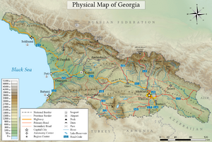
Georgia is a mountainous country situated almost entirely in the South Caucasus, while some slivers of the country are situated north of the Caucasus Watershed in the North Caucasus. The country lies between latitudes 41° and 44° N, and longitudes 40° and 47° E, with an area of 66,820 km2 (25,800 sq mi). The Likhi Range divides the country into eastern and western halves. Historically, the western portion of Georgia was known as Colchis while the eastern plateau was called Iberia. [[||300px|thumb|left|caption.]]
The Greater Caucasus Mountain Range forms the northern border of Georgia. The main roads through the mountain range into Russian territory lead through the Roki Tunnel between Shida Kartli and North Ossetia and the Darial Gorge (in the Georgian region of Khevi). The southern portion of the country is bounded by the Lesser Caucasus Mountains. The Greater Caucasus Mountain Range is much higher in elevation than the Lesser Caucasus Mountains, with the highest peaks rising more than 5,000 metres (16,404 ft) above sea level.
The highest mountain in Georgia is Mount Shkhara at 5,203 metres (17,070 ft), and the second highest is Mount Janga at 5,059 m (16,598 ft) above sea level. Other prominent peaks include Mount Kazbek at 5,047 m (16,558 ft), Shota Rustaveli Peak 4,960 m (16,273 ft), Tetnuldi 4,858 m (15,938 ft), Ushba 4,700 m (15,420 ft), and Ailama 4,547 m (14,918 ft). Out of the abovementioned peaks, only Kazbek is of Wikipedia:Volcano:volcanic origin. The region between Kazbek and Shkhara (a distance of about 200 km (124 mi) along the Main Caucasus Range) is dominated by numerous glaciers.
The term Lesser Caucasus Mountains is often used to describe the mountainous (highland) areas of southern Georgia that are connected to the Greater Caucasus Mountain Range by the Likhi Range. The overall region can be characterized as being made up of various, interconnected mountain ranges (largely of volcanic origin) and plateaus that do not exceed 3,400 metres (11,155 ft) in elevation. Prominent features of the area include the Javakheti Volcanic Plateau, lakes, including Tabatskuri and Paravani, as well as mineral water and hot springs. Two major rivers in Georgia are the Rioni and the Mtkvari.
Topography
The landscape within the nation's boundaries is quite varied. Western Georgia's landscape ranges from low-land marsh-forests, swamps, and temperate rainforests to eternal snows and glaciers, while the eastern part of the country even contains a small segment of semi-arid plains.
Much of the natural habitat in the low-lying areas of western Georgia has disappeared during the past 100 years because of the agricultural development of the land and urbanization. The large majority of the forests that covered the Colchis plain are now virtually non-existent with the exception of the regions that are included in the national parks and reserves (e.g. Lake Paliastomi area). At present, the forest cover generally remains outside of the low-lying areas and is mainly located along the foothills and the mountains. Western Georgia's forests consist mainly of deciduous trees below 600 metres (1,969 ft) above sea level and contain species such as oak, hornbeam, beech, elm, ash, and chestnut. Evergreen species such as box may also be found in many areas. Ca. 1000 of all 4000 higher plants of Georgia are endemic to this country.
Several locations in Samegrelo and Abkhazia are covered by temperate rain forests. Between 600–1,000 metres (1,969–3,281 ft) above sea level, the deciduous forest becomes mixed with both broad-leaf and coniferous species making up the plant life. The zone is made up mainly of beech, spruce, and fir forests. From 1,500–1,800 metres (4,921–5,906 ft), the forest becomes largely coniferous. The tree line generally ends at around 1,800 metres (5,906 ft) and the alpine zone takes over, which in most areas, extends up to an elevation of 3,000 metres (9,843 ft) above sea level. Eastern Georgia's landscape (referring to the territory east of the Likhi Range) is considerably different from that of the west, although, much like the Colchis plain in the west, nearly all of the low-lying areas of eastern Georgia including the Mtkvari and Alazani River plains have been deforested for agricultural purposes.[citation needed] The general landscape of eastern Georgia comprises numerous valleys and gorges that are separated by mountains. In contrast with western Georgia, nearly 85 per cent of the forests of the region are deciduous. Coniferous forests only dominate in the Borjomi Gorge and in the extreme western areas. Out of the deciduous species of trees, beech, oak, and hornbeam dominate. Other deciduous species include several varieties of maple, aspen, ash, and hazelnut.
At higher elevations above 1,000 metres (3,281 ft) above sea level (particularly in the Tusheti, Khevsureti, and Khevi regions), pine and birch forests dominate. In general, the forests in eastern Georgia occur between 500–2,000 metres (1,640–6,562 ft) above sea level, with the alpine zone extending from 2,000–2,300 to 3,000–3,500 metres (6,562–7,546 to 9,843–11,483 ft). The only remaining large, low-land forests remain in the Alazani Valley of Kakheti.
Climate
The climate of Georgia is extremely diverse, considering the nation's small size. There are two main climatic zones, roughly corresponding to the eastern and western parts of the country. The Greater Caucasus Mountain Range plays an important role in moderating Georgia's climate and protects the nation from the penetration of colder air masses from the north. The Lesser Caucasus Mountains partially protect the region from the influence of dry and hot air masses from the south.
Much of western Georgia lies within the northern periphery of the humid subtropical zone with annual precipitation ranging from 1,000–2,500 mm (39–98 in), reaching a maximum during the Autumn months. The climate of the region varies significantly with elevation and while much of the lowland areas of western Georgia are relatively warm throughout the year, the foothills and mountainous areas (including both the Greater and Lesser Caucasus Mountains) experience cool, wet summers and snowy winters (snow cover often exceeds 2 metres or 6 feet 7 inches in many regions).
Eastern Georgia has a transitional climate from humid subtropical to continental. The region's weather patterns are influenced both by dry Caspian air masses from the east and humid Black Sea air masses from the west. The penetration of humid air masses from the Black Sea is often blocked by mountain ranges (Likhi and Meskheti) that separate the eastern and western parts of the nation. The wettest periods generally occur during spring and autumn, while winter and summer months tend to be the driest. Much of eastern Georgia experiences hot summers (especially in the low-lying areas) and relatively cold winters. As in the western parts of the nation, elevation plays an important role in eastern Georgia where climatic conditions above 1,500 metres (4,921 ft) are considerably colder than in the low-lying areas.
Biodiversity
See also: List of Fauna of Georgia and List of fish of the Black Sea
Because of its high landscape diversity and low latitude, Georgia is home to about 5,601 species of animals, including 648 species of vertebrates (more than 1% of the species found worldwide) and many of these species are endemics. A number of large carnivores live in the forests, namely Brown bears, wolves, lynxes and Caucasian Leopards. The common pheasant (also known as the Colchian Pheasant) is an endemic bird of Georgia which has been widely introduced throughout the rest of the world as an important game bird. The species number of invertebrates is considered to be very high but data is distributed across a high number of publications. The spider checklist of Georgia, for example, includes 501 species. The Rioni River may contain a breeding population of the critically endangered bastard sturgeon.
Slightly more than 6,500 species of fungi, including lichen-forming species, have been recorded from Georgia, but this number is far from complete. The true total number of fungal species occurring in Georgia, including species not yet recorded, is likely to be far higher, given the generally accepted estimate that only about seven per cent of all fungi worldwide have so far been discovered. Although the amount of available information is still very small, a first effort has been made to estimate the number of fungal species endemic to Georgia, and 2,595 species have been tentatively identified as possible endemics of the country. 1,729 species of plants have been recorded from Georgia in association with fungi. According to the International Union for Conservation of Nature, there are 4,300 species of vascular plants in Georgia.
Georgia is home to four ecoregions: Caucasus mixed forests, Euxine-Colchic deciduous forests, Eastern Anatolian montane steppe, and Azerbaijan shrub desert and steppe. It had a 2018 Forest Landscape Integrity Index mean score of 7.79/10, ranking it 31st globally out of 172 countries.

