Rutenga
This article is incomplete because it is pending further input from participants, or it is a work-in-progress by one author. Please comment on this article's talk page to share your input, comments and questions. Note: To contribute to this article, you may need to seek help from the author(s) of this page. |
Democratic Republic of Rutenga | |
|---|---|
|
Flag | |
 | |
| Capital and largest city | N'geza |
| Official languages | Camrian Xuddoaga |
| Ethnic groups (2015) | 41% Mebou, 28% Dintu, 11% Xuddoaga, 5% Ubar, 5% Irneku, 3% Dige, 7% Other |
| Demonym(s) | Rutengan |
| Government | Multi-Party Umunna State |
• President | Imohimi Charif |
| Legislature | Parliament of Rutenga |
| National Assembly | |
| Council of Rutenga | |
| Establishment | |
• Mebou Kingdom est. | 12th Century |
• Kingdom of Mebouland and Dintuland est. | 19XX |
• Democratic Republic of Rutenga est. | 1973 |
| Population | |
• 2020 estimate | 46,000,000 |
• 2015 census | 44,203,477 |
| GDP (PPP) | 2020 estimate |
• Total | 281.152 billion |
• Per capita | $6,112 |
| GDP (nominal) | 2020 estimate |
• Total | 166.934 billion |
• Per capita | $3,629 |
| HDI (2015) | medium |
| Driving side | right |
| Internet TLD | .ru |
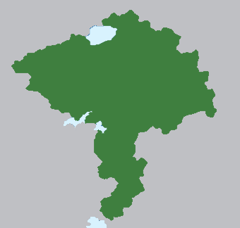
Rutenga, officially the Democratic Republic of Rutenga is a sovereign state in Majula, in the Southern Hemisphere of Aeia. The Democratic Republic of Rutenga governs over 11 Autonomous Provinces and 8 Regular Provinces. To the Southwest, it borders the Union of Odo, while to the North and West it borders XXXX. Rutenga is a mid population nation, with 44 million people as of the 2016 census, though it has a high growth rate and this population is expected to more than double over the next 25 years. N'geza is the capital and largest city of Rutenga.
Songha is the third largest nation in Majula, in both land and area. The population of Rutenga is relatively well dispersed with the exception of the South, where population density is higher than the rest of the country.
History
Early History
Both the savannahs and rainforests in Rutenga have been inhabited since early times by the Mebou, Xuddoaga, Ubar-Dige, Irneku and Dintu peoples, among dozens of others. Ethnic boundaries have shifted over time, and while a number of groups have appeared and disappeared, many of the ethnic groups of Modern Rutenga can trace their roots back tens of thousands of years. Civilisation in the form of settlements began to take shape roughly 200 BCE; however, it was not until the Transaharan Trade, beginning in the 5th Century, that societies of Mebou, Irneku and Dintu peoples began to flourish.
This would lay the foundations for the close relationship between Odo and Rutenga that exists to this day, as well as the foundations for the Mebou Kingdom - the first Rutengan Kingdom to conquer significant portions of its land and populace. The Mebou Kingdom would conquer the North of what is now Rutenga, uniting much of the Mebou Peoples, while expanding their territory to the north, at the expense of the Irneku People.
The Mebou Kingdom played a significant part in the First Majulan Radiance, with Kings of the era emphasising culture, language and art, and founding the city of N'geza in the 14th Century. However; in the 16th Century, the Mebou Kingdom falls into chaos following the death of it's last King, Zahi III, without a clear heir. Initial fighting over who should rule the Kingdom ultimately leads to its demise, and in the chaos, Northern Rutenga fractures into disorganised states until its occupation by the Aghiri Empire and incorporation as the Province of Mebou.
Aghiri Empire and Colonial Era
Under the Aghiri Empire, the Province of Mebou grew slowly but steadily, while the city of N'geza provided a Central Hub for Mebou and Aghiri traders to reach the interior of Majula, thus presenting itself as a strategic trading hub for resources such as Gold, Ivory and Slaves. Slaves of this period were primarily Xuddoaga, Agko and Ubar-Dige peoples are the borderlands of the Province, either bought from warring tribes, or seized directly during raids. It is this period of history, under the Aghiri Empire, where much of the legitimacy for a Pan-Majulan identity comes from in the modern era.
However, this period wouldn't last very long, as the Aghiri Empire collapsed int he 18th Century. The lands of Rutenga fell into relative obscurity as trade was at an all-time low following the chaos to the Southwest; however, during this period, a successor to the Mebou Kingdom existed, though much smaller in scope, based in N'geza.
As the Camrian South Majula Company slowly consolidated control and influence over the lands of Odo, similarly its influence spread - albeit more slowly - to the lands of Rutenga. Not long after the lands of Odo were brought under the crown of Camria, the lands of Rutenga were similarly brought into colonial administration, with the division of Rutenga into the Mebouland Province and the Dintuland Province, which would go on to form the basis for the modern-day borders of Rutenga.
Camrian colonial administration brought missionaries from Asura, who slowly established communities of Alydianism; the most successful of which being the Irneku People in the north, who largely converted to Alydianism. In the rest of the provinces, smaller communities converted; however, due to their placement in the Interior of Majula, as well as the relative isolation of the Rutengan Provinces, much of the area was left relatively alone.
In the next Century, as the Odo People rebelled against Colonial rule, the Rutengan provinces grew increasingly abandoned by Camria as their position was simply inaccessibly without reliable and stable access through Odo; as a result, the Royalty of Mebouland and Dintuland brokered a deal to declare the Kingdom of Mebouland and Dintuland in the early 20th Century.
Kingdom of Mebouland and Dintuland
The Kingdom of Mebouland and Dintuland was indeed the first unified nation-state to rule Rutenga as a single country. Each of these lands were ruled by an independent King, resulting in a very precarious geopolitical situation. While foreign affairs and the military were unified under a Diarchical System, virtually every other aspect of Rutenga was divided between the two Kingdoms, including Judicial, Legislative, Finances, amongst others.
Following independence, Mebouland was already more populated, and developed - being home to the largest city, N'geza. Additionally, Mebouland was more arable, and had a historical status as a trade centre for Central Majula, thus giving it an advantage in many aspects. In the meanwhile, Dintuland was much less arable and developed, and was much more divided among ethnicities, unlike the more homogenous Mebouland. These issues slowly racked up, with tension slowly building over the decades.
These issues were amplified by the international rubber trade; as demand began increasing, Mebou Companies moved into Dintuland, opening plantations and ultimately coming to dominate the Rutengan Rubber Industry, despite most rubber being in Dintu territory. This, among other issues, ultimately led to the Rutengan Split, wherein Dintuland declared independence, and attempted to enforce nationalisation of the rubber plantations.
A civil war would break out, raging for 14 months, before the economically and militarily dominant Mebouland subjugated Dintuland. Thus forwards, the Kingdom of Mebouland and Dintuland was no longer a Diarchy; but a Monarchy, yet retained the namesake of the Diarchy for posturing. As a result of the Civil War, Rutenga was united under Mebou legislative and judicial law, and the Mebou Capitalist Class came to control much of the economy of former Dintuland.
Second Civil War to Present
Unrest once again began building in Rutenga, as decades of Mebou dominance over nearly every aspect of the country fuelled increasing frustration and anger.
Geography
Government & Politics
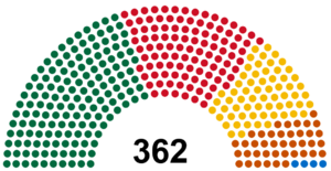
Composition of the National Assembly

