User:Finium/Sandbox11
Republic of Venikara
| |||||||
|---|---|---|---|---|---|---|---|
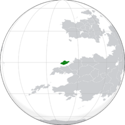
 Location of Venikara in the Achelonian Sea | |||||||
| Capital and largest city | Ratukæṭa | ||||||
| Demonym(s) | Venikaran | ||||||
| Government | Presidential Republic | ||||||
• President | Senarat Paranavithana | ||||||
• Vice President | Sanath Weerakoon | ||||||
• Secretary-General | Malcolm Ranjith | ||||||
| Legislature | General Congress | ||||||
| Area | |||||||
• Venikara Proper | 154,668 km2 (59,718 sq mi) | ||||||
| Population | |||||||
• Estimate | 38,200,210 | ||||||
• Density | 247/km2 (639.7/sq mi) | ||||||
| GDP (PPP) | estimate | ||||||
• Total | 172.5 billion | ||||||
• Per capita | 4,517 | ||||||
| GDP (nominal) | estimate | ||||||
• Total | 44.6 billion | ||||||
• Per capita | 1,170 | ||||||
| Currency | New Fanon (ෆ) | ||||||
Venikara, officially the Republic of Venikara, is a country in the Southeast Achelonian Sea, north of Patasura and Rajyaghar.
Etymology and names
Venikara was named for it's location on the equator, a feature that attracted the attention of early priests and astrologers who would travel to Mount Ulukhala to make observations. Venikara is therefore a combination of the Tankari words னில் (vēṉil, "sunshine") and கரை (karai, "place" or "shore"), so named because of the equatorial direct sunlight present on the island.
Historically, all of the islands along the north coast of Satria were known as the Mauktikanam Islands (Parbhan: मौक्तिकानाम्) for the pearls found in the area. The island chain was sometimes called the Northern Palasa (Parbhan: पलाश), combining with the transmontane coastal area to form the north "petal" of the Satrian flower. In Tankari, the islands were known as Mariyai (மாரியை), the Rainy Islands for the persisent precipitation.
In Pardaria, the island was known as Mizbanak (Pardaran: میزبانک), a term occassionally also translated into Parbhan as Mezbanu.
Ths islands may have been known to Euclea cartographers relatively early, but it is unclear to what extent their knowledge was of Venikara, Satria in general, or simple mistakes from chains of translation of information along the Achelonian rim. In the 11th century, Laurenco de Felino created a map of the Achelonian Sea which had an island approximately in the location of Venikara labelled "Palvera", but this was almost certainly a misplacement of Shimorgh Island, one of the Khazal Islands since the same name was featured in Cesare Enzignerio-Favri's letter and commission as governor. Later Etrurian sailors reaching the island in the 14th Century referred to the large island as "Caspi", but actually believed it was a peninsula at the time. Eventually a Soravian expedition sailing from the Ravnian isle directly south encountered Venikara, sailed around it to the south to the Tankari port at Maunakal, appearing Мунакал in their publication.
Мунакал or Munakal was later romanized by Etrurian and Gaullican cartographers as munición, from which the populat term the "Munition Islands" was derived.
During the colonial period, however, the name Nelumbo (Sinhalese: නෙලුම්බ) was adopted for the official territory, although Sainte-Monique was also proposed.
History
Colonial period
- first colonial exclave
- lease agreements or bankruptcy
- colonial government established
- extensive shelling of Gaullican naval assets in the north during the great war
- Etrurian occupation begins in 1936