Whittvale
Republic of Whittvale | |
|---|---|
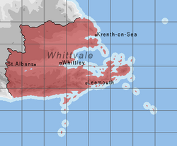
 Political map of Whittvale. | |
| Capital | Whittley |
| Largest city | Whittley (city proper) Whittmouth (metropolitan area) |
| Official language | English, Whitt, regional dialects |
| Demonym(s) | Whitt |
| Government | Parliamentary Republic |
• President | Thomas Upton |
| Senate | |
| Parliament | |
| Establishment | |
• First Charter of Unification | 1325 |
• Second Charter of Unification | 1548 |
• Acts of Abdocation | 1820 |
| Population | |
• 2018 estimate | |
| Currency | Whitt Rand (WR) |
| Internet TLD | .wv |
Whittvale, officially the Republic of Whittvale, is a country in Seora. The country is made of, and takes its name from, the vales of the rivers Whitt and Thunn. The country's capital and largest city is Whittley. The country has a population of roughly 84 million people. The official language is English, however several local dialects are also recognized.
Etymology
History
Early Period
Whittvale's archeological record goes as far back as 3,500 bc with the oldest finds coming from sites in the Upland Counties along tributaries of the Whitt and Thunn rivers. Evidence of stone tools, pottery and bureal mounds paint a picture of a tribal society which may have settled down and adopted agriculture as early as 2,800 bc. Distinct groupings can be made between the settled peopled of the area, dealt neatly into the Whitt and Thunn cultures. The first large settlements also go back to this period, some of which are still inhabited today. The origins of Whittvale's counties go back to this tribal period.
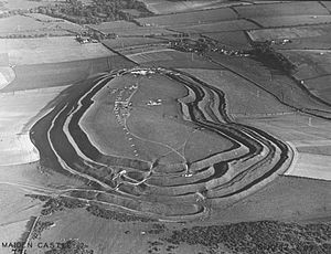
By 500 ad the first signs of more organised settlement start to manifest in the petty-kingdoms, which would later become the Duchies. The oldest and most imposing site, the walled city of Olde-Canley, was the seat of the Petty Kingdom of Whittan and dates back to the fifth century ad. A common trend to many of the walled settlements was the distinct multi-layered earthworks which surrounded the oppidium-like cities. From these expansive sights, the Petty Kings excercised their power throughout the Vales, consolidating their power over the centuries until they formed rigid fuedal societies around their leaders. At this point, Christianity began to spread throughout Whittvale.
A notable exception the trend of feudalisation are the southernmost reaches of Whittvale along the country's southern coast. The rugged terrain enabled the villages and towns to excercise more freedom, later deveopling into Free Counties. The cities that formed along the southern coast turned their focus to the trading and other maritime affairs. The maritime influences on this region can be seen in the cuisine, archetecture and festivities of the southern cities. In the Thunn Vale, in the north of what is now Whittvale, the process of consolidation took much longer due to several factors including the rural nature of the area, lower population and the Thunn being a much smaller river which made it harder to navigate, hampering trade. The Thunn counties would remain free until the sixteenth century when they too would fall under the influence of the Whitt kings.
Kingdom of the Whitt
By the tenth century, the Petty Kingdom of Whittan's influence over the Vale had increased to the point where the Kings of Whittan were for all intents and purposes the de facto kings of the Whitt Vale, the other rulers paying hommage to them. Whittan had reached this point through a careful web of adventagious marriages, trade agreements and being on the right side of the many conflicts that raged throughout the Vale. This hold was solidified in 1325 with the first Act of Unification, forming the Kingdom of the Whitt under King Edmund I. The new kingdom's capital was quickly moved from Olde-Canley to the centrally located city of Saint Albans-in-the-Vale where the first royal court was established. The former Petty-Kingdoms were allowed to continue to exist as duchies in the new kingdom. The families were permitted to maitain their rule over their lands as vassals under the new high king.
Kingdom of the Thunn
With the consolidation of the Kingdom of the Whitt to the south, the Thunn counties slowly coagulated into its own unified political entity. In 1310 the heads of the counties came together to discuss their future at Farthing castle. The Farthing Acts would see the counties come together to form an elective monarchy along the Thunn Vale, mirroring that of their southern neighbors. The elective system would be upheld for almost two centuries until the polittical and dynastic influence of the Counts of Krenth saw a change towards a de facto heriditary monarchy with its capital in Krenth-on-Sea which was formally adopted in 1510. The Kingdom of the Thunn would retain some rights of the free counties, however by this time the free counts had lost much of their power to the cities and their guilds, offering little resistance to their adoption into the newly formed kingdom.
Kingdom of the Two Vales
While the Kingdom of the Whitt had consolidated into a more or less unified entity by the sixteenth century, the formation of a centrally unified kingdom in the north exaserbated existing problems which had gone back to antiquity. Border skirmishes and clashes between counties along the two kingdom's respective marches had been the most pressing of these issues, and with the newfound authority of the two kingdoms, this could finally be effectively addressed. The first effort to see these skirmishes put to an end came in the form of correspondance between the two courts, and the subsiquent tightening of authority on the march counts on both sides of the border. Further efforts to bring the two kingdoms together would go on until the first royal marriage between the northern and southern kingdoms in 1548, forming the Kingdom of the Two Vales.
Modern Whittvale
By the dawn of the nineteenth century, a number of factors led to friction between the differenc classes within the kingdom, and led to a degree of unrest. Firstly, many counties had been incorpoerated into the lands of the respective rulers through inheritance over centuries of marriages, giving the monarchs more power over time. Secondly, industrialisation led to liberal movements sprouting up in the larger cities as people left the countryside in pursuit of work, as land owners and the nobility accrued more land. By now the influence of the church had also increased to the point where the local peasantry had little prospect of owning their own lands, let alone the ability to purchase their own parcels.
