Yukayeke paths

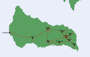
The Yukayeke paths (Lusitan: Caminhos de Yukayeke), also known as the Yukayeke network or Yuka Highways and referred to by the indigenous population as Oabóroka (lit. "the paths") are a series of expansive paved roads built by the indigenous Natí population of Maracao. Spreading across much of the island, but concentrated densely in the east, the Yukayeke paths were often used for travel across the island, including travel between towns and other settlements, farmlands, shrines, the ocean, as well as paths of pilgrimage.
Historians believe some paths to be over a thousand years old, and thus built well before Euclean contact with the Asterias. The size of the path network is unusual for its position as the Nati population were not regarded as one of the Asterias' advanced civilisations. Many of the paths were built over by Lusitan colonists in the 16th and 17th centuries, particularly for plantations, but some were used to navigate the island initially and many remained in use by the Lusitan throughout its colonial period. Since 1939, the paths have been prohibited from any motorised or heavy vehicles, and are mostly used for pedestrian tourism.
Name
The widespread name for the roads, the Yukayeke paths, comes from the tribal city of Yukayeke, believed by historians to be the centre of the Natí peoples in Maracao.
Many paths led to Yukayeke, and its location in eastern Maracao likely made it the centre of the network. The first mention of the name "Yukayeke path" was in 1688, in a Lusitan book on the pre-Asterian Arucian.
The indigenous name, oabóroka (singular oabóroko) is believed to translate literally into "paths" in the Nati language.
Usage
The Yukayeke paths were known for their variety and versatility in destination, and paths have been found across Maracao, with termini in a plethora of significant locations. Historians believe that the main use of the paths was to ease travel between major tribal towns settled throughout Maracao. Yukayeke itself is believed to have had as many as ten separate paths beginning or ending within its borders, including the longest path, which ran from Yukayeke to Guanimina, around 50 kilometres south of modern-day Alfeite.
As well as cities, the paths were often used to traverse low-visability terrain (mainly dense rainforest) to reach farmlands and bodies of water, including the ocean, where the Nati gathered most of their food. While fishing was a major source of food for the Nati population, they were also known for their cultivation of a wide range of natural crops, including beans, sweet potatoes, nuts, yams as well as local crops such as cassava, all of which were staple foods of the Nati people. Farms connected by Yukayeke paths were often prosperous, and crops were carried back to tribal towns in head-mounted hand-weaved baskets known as Jaba, where they would often be bartered or traded in large tribal markets known as babauta. Many Yukayeke farmers are believed to have been subsistence farmers, who traded excess produce in exchange for valuable materials such as gold and silver.
Pilgrimage paths and shrine paths was other one of the main uses of the Yukayeke paths, with connections to small temples and shrines being common throughout the paths. More often than not, shrines were located on or near the paths themselves (for the latter, small diversions were sometimes made) and served as a place of worship along the paths. Larger and more significant shrines often received their own paths for increased traffic and pilgrimages, especially to Guanimina, a popular pilgrimage to worship the Natí sun god Taigüey, as the sun set in the west. Many of the Yukayeke paths built for pilgrimages were destroyed by colonists in the 16th century, with no paths purpose-built for pilgrimage existing today.
Construction
Yukayeke paths were known for their simple and quick construction, which consisted mainly of a thin layer of pebbles or stones paved over with early forms of stucco, formed by mixing small stones, gravel and sand together with water, which eventually settled into a durable solid. Roads were lined with larger stones to demarcate the paths and make them easier to follow. While construction of the paths was simple, attaining and forming the materials needed in the quantity they were used heavily implies the use of forced or potentially slave labour by the caciques of the Natí tribe.
Modern usage
Yukayeke paths have lost all of their original purpose, and are no longer used for any sort of meaningful transportation within Maracao, although they were briefly used in the mid-1930s in the short years after its independence, before their usage as modern roads was outlawed by Renato Guimarães in 1939. Josué Couto later designated them as "essential pieces of Maracan cultural heritage" in 1946 as part of a larger trend of pro-native reforms in the country.
Mainly, they are used for tourism purposes today. Many tour guides exist on the Yukayeke paths, especially around Yukayeke, whose ruins are situated near the city of Garriapa. The Maracan government funds annual maintenance for the paths, whose makeshift stucco is extremely cracked and chipped, and is it a large bringer of tourism into Maracao, which the government heavily incourages.
