Wareselt
Republic of Wareselt | |
|---|---|
|
Flag | |
 | |
| Capital | Taveil |
| Largest city | Halstel |
| Government | |
| Wesley Bonaparte | |
| Population | |
• 2024 estimate | 9,061,000 |
| Date format | mm-dd-yyyy |
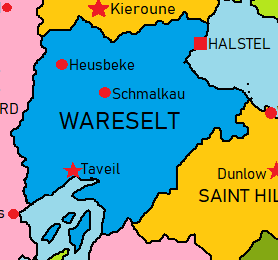
The Republic of Wareselt is a country in northeast Nortua, bordered to the north by Eastern Holin, to the west by Tine, to the south by Kamani, and to the west by Saint Hilley. It also shares maritime borders with Candatora by Bremic Lake, and the Arenoran Isles by the Strait of Mitter. Wareselt has a population of roughly 9.1 million people. Its capital is Taveil, its largest city is Halstel, and other major cities include Schmalkau and Heusbeke. Wareselt has a varied terrain, ranging from high plains along with rolling hills and mountains, some of which reach an altitude of over 1,250 m (3,600 ft), to low plains along the northeast coast and southern lakelands.
Wareselt and Hilley became an independent republic in 1939. In 1948, Saint Hilley peacefully broke away from Wareselt in a democratic referendum, and the two maintain strong political and cultural ties.
Wareselt is a developing country, with an upper-middle-income economy. Wareselt is dominated by the services sector, accounting for 54% of GDP and employing approximately 56.6% of the population. It has experienced solid economic growth over the last decade. It has large reserves of lead, zinc, silver, nickel, cobalt, copper, iron and bauxite. 53% of the nation's area is agricultural land, 41% forest and forestry land, and 6% for others. Wareselt is a member state of several international organizations, including the CCA, ANS, and CTO.
