Fonualei: Difference between revisions
Jump to navigation
Jump to search
No edit summary |
No edit summary |
||
| (One intermediate revision by the same user not shown) | |||
| Line 58: | Line 58: | ||
|sovereignty_type = Independence | |sovereignty_type = Independence | ||
|sovereignty_note = | |sovereignty_note = | ||
|established_event1 = | |established_event1 = Matai Rebellion | ||
|established_date1 = | |established_date1 = 1920 | ||
|established_event2 = | |established_event2 = Treaty of Namiwan | ||
|established_date2 = | |established_date2 = 1923 | ||
|area_rank = | |area_rank = | ||
|area_magnitude = | |area_magnitude = | ||
| Line 120: | Line 120: | ||
}} | }} | ||
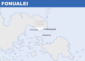
'''Fonualei''' ({{wp|Help:IPA/Tongan|/fɔnʉalɛae/}}; {{wp|Tongan language|Fonualeian}}: ''Fonualei'') known officially as the '''Kingdom of Fonualei''' ({{wp|Tongan language|Fonualeian}}: ''Puleʻangaʻo Fonualei''), is {{wp|sovereign state}} in | '''Fonualei''' ({{wp|Help:IPA/Tongan|/fɔnʉalɛae/}}; {{wp|Tongan language|Fonualeian}}: ''Fonualei'') known officially as the '''Kingdom of Fonualei''' ({{wp|Tongan language|Fonualeian}}: ''Puleʻangaʻo Fonualei''), is {{wp|sovereign state}} in [[Savai]]. It borders [[South Misai]] to the north and is bounded by the [[Sea of Savai]] to the south and east, thus sharing maritime borders with [[Agarntrop]]. The Kingdom comprises of a mainland and its offshore islands, spanning an area of X sq. km (X sq. mi) in total. The capital and largest city is the port town of Nukupule, home to 64% of the country's population of around 340,000 people. | ||
Latest revision as of 16:05, 17 April 2020
This article is incomplete because it is pending further input from participants, or it is a work-in-progress by one author. Please comment on this article's talk page to share your input, comments and questions. Note: To contribute to this article, you may need to seek help from the author(s) of this page. |
Kingdom of Fonualei Puleʻanga ʻo Fonualei (Fonualeian) | |
|---|---|
| Motto: ʻE ʻOtua Māfimafi "Oh Almighty God Above" | |
| Anthem: Ko Koe Ko e Falalaʻanga "Our Lord the Pillar" | |
 Location of Talailau (in green) in X (grey). | |
| Capital and | Nukupule |
| Official languages | Fonualeian |
| Active Military | 2,572 (2015) |
| Ethnic groups | 82.6% Fonualeian 16.3% Misaian 1.1% Others |
| Demonym(s) | Fonualeian |
| Government | Democratic elective monarchy |
| Mataeula Tuʻipulotu | |
| Heuʻifanga Fe’ao | |
| Legislature | Council of Chiefs |
| Independence | |
• Matai Rebellion | 1920 |
• Treaty of Namiwan | 1923 |
| Area | |
• | 00,000 km2 (0 sq mi) |
| Population | |
• 2014 census | 347,139 |
• Density | 000/km2 (0.0/sq mi) |
| GDP (nominal) | 2017 estimate |
• Total | $1.426 billion |
• Per capita | $4,109.84 |
| Gini (2014) | 45.9 medium |
| HDI (2017) | 0.707 high |
| Currency | paʻanga (FNP) |
| Date format | dd.mm.yyyy |
| Driving side | right |
| Calling code | +420 |
| ISO 3166 code | FNL |
| Internet TLD | .fn |
Fonualei (/fɔnʉalɛae/; Fonualeian: Fonualei) known officially as the Kingdom of Fonualei (Fonualeian: Puleʻangaʻo Fonualei), is sovereign state in Savai. It borders South Misai to the north and is bounded by the Sea of Savai to the south and east, thus sharing maritime borders with Agarntrop. The Kingdom comprises of a mainland and its offshore islands, spanning an area of X sq. km (X sq. mi) in total. The capital and largest city is the port town of Nukupule, home to 64% of the country's population of around 340,000 people.
