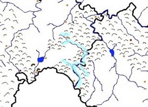
River Andoma: Difference between revisions
Jump to navigation
Jump to search
No edit summary |
No edit summary |
||
| Line 22: | Line 22: | ||
| pushpin_map_alt = | | pushpin_map_alt = | ||
<!---------------------- LOCATION --> | <!---------------------- LOCATION --> | ||
| subdivision_type1 = Country | | subdivision_type1 = Country(s) | ||
| subdivision_name1 = [[Kingdom of Blechingia|Blechingia]], [[Lyonheimer]] | | subdivision_name1 = [[Kingdom of Blechingia|Blechingia]], [[Lyonheimer]] | ||
| subdivision_type2 = | | subdivision_type2 = Proveince(s) | ||
| subdivision_name2 = | | subdivision_name2 = [[Swabia]] | ||
| subdivision_type3 = Citys | | subdivision_type3 = Citys | ||
| subdivision_name3 = [[Diepholz]],[[Kempten]] | | subdivision_name3 = [[Diepholz]], [[Kempten]] | ||
| subdivision_type4 = | | subdivision_type4 = | ||
| subdivision_name4 = | | subdivision_name4 = | ||
Revision as of 17:46, 5 March 2021
| River Andoma | |
|---|---|
 | |
 | |
| Native name | Götaish: Andœma |
| Location | |
| Country(s) | Blechingia, Lyonheimer |
| Proveince(s) | Swabia |
| Citys | Diepholz, Kempten |
| Physical characteristics | |
| Mouth | Bay of Asta |
• elevation | Sea Leavel (0 m) |