Anirniq: Difference between revisions
m (same as before) |
m (Date changes) |
||
| (13 intermediate revisions by the same user not shown) | |||
| Line 1: | Line 1: | ||
{{Region_icon_Ajax}} | {{Region_icon_Ajax}} | ||
{{wip}} | |||
{{Infobox islands | {{Infobox islands | ||
| name = Anirniq | | name = Anirniq | ||
| image_name = | | image_name = [[File:Fuglefjellet øst.jpg|250px]] | ||
| image_caption = The island as seen approaching from the east | | image_caption = The island as seen approaching from the east | ||
| image_size = | | image_size = | ||
| map_image = | | map_image = | ||
| map_caption = | | map_caption = | ||
| Line 31: | Line 32: | ||
| country_largest_city = | | country_largest_city = | ||
| country_largest_city_population = | | country_largest_city_population = | ||
| population = | | population = 42 | ||
| population_as_of = 2021 | | population_as_of = 2021 | ||
| population_footnotes = <br><small>Population consists of semi-permanent researchers and ecologists.</small> | | population_footnotes = <br><small>Population consists of semi-permanent researchers and ecologists.</small> | ||
| density_km2 = | | density_km2 = | ||
| languages = | | languages = | ||
| ethnic_groups = | | ethnic_groups = | ||
| timezone1 = | | timezone1 = | ||
| Line 43: | Line 44: | ||
}} | }} | ||
'''Anirniq''' ({{ | '''Anirniq''' (''[[Awasi:]]'' {{IPAc-en|æ|nj|ɪr|nj|iː|k}}) is an island in [[Winivere Bay]] and the only island territory held by [[Awasin]]. It is believed to have been discovered by [[Kaal'ga Jaad]] explorers in the ninth century and was inhabited by [[Ch'iyakem]] peoples from the tenth through the fourteenth centuries. Its name is a loanword from a northern language family term of the same name. Though mapped in 1696, it was not officially recognized as Awasi territory until 1886. | ||
Due to its location within the bay and distance from the mainland the island was the site of a permanently-manned military installation from | Due to its location within the bay and distance from the mainland the island was the site of a permanently-manned military installation from 1887 to 1963. It was demilitarized by 1965 and converted to its present state as a {{wp|nature reserve}}, though various corporations and private interests have attempted to lobby for mining and {{wp|whaling}} rights. As of 2021 the sole settlement on the island is a government research station on the island's western cliffs. | ||
==History== | ==History== | ||
[[File:Whale bone at the abandoned whaling station.jpg|thumb|250px|left|Remnants from unknown settlement]] | |||
[[File:Anirniq-manor.jpg|thumb|Blackhand Manor, Sdal'aan]] | |||
Anirniq was discovered and inhabited sequentially by multiple coastal peoples from modern-day Awasin, forming the [[Daag'niaa culture]]. Remnants of seasonal settlements and deep-water canoes have been found in a cave dating to 1230-1570 CE. The Jaad name for the island is ''Jai'itt'agahdaw'', which means 'island of cold rock.' Early [[Wazheganon#Ethnic groups|Umbier]] explorer Coenraad Thanhoren sighted the island on his second expedition in the bay. Further exploration followed in 1699 and 1701 with much consideration given to the rich population of {{wp|seabirds}} and southernly {{wp|seals}}. From the early eighteenth century it was used as a base for fishing expeditions and seal hunts. Eggs of seabirds were harvested on regular bases until 1951. | |||
Several settlements were constructed on the island in the 1750s, though none lasted longer than two winters owing to a lack of funding and declining availability of natural resources. The largest of these, [[Siiskutla]], remains well-preserved on the beach of a northwestern inlet. Political upheaval and [[Wazheganon#Great Norumbia|military presence]] on the mainland caused interest in Anirniq to dwindle until the newly-formed nation of Awasin declared the island an important strategic asset. Construction on a military base began in 1900, and by 1925 the island was home to just over 300 personnel. | |||
[[Awasin#Geography#Climate|Environmental treaties]] and protection acts recognized in the late 1940s prompted a transitioning of many permanent outposts to research duties, as well as a renewed focus on part of [[Sikimiohkitopii I]] regarding demilitarization. Anirniq was declared a transitionary zone in 1950. The island was mostly depopulated and removed of military equipment by 1962, though a small contingent of researchers and officers remained to protect the area in the interim until economic interest could be safely rebuffed. The base and surrounding village was converted to a research station, [[Sdal'aan]], in 1968 which is today the only populated region on the island. The station contains {{wp|landing platforms}} for use by government helicopters and private ecological groups. It is recognized as a unique example of Awasi fusion architecture, with numerous buildings in a distinctly [[Arthurista|Arthuristan]] style. | |||
Multiple post-secondary trips and climatological studies are carried out on a biyearly basis. The largest of these is the [[Otsskoimitaa University]]'s seabird study, first undertaken in 2002. {{wp|Amateur radio operators}} have conducted private expeditions with aid from the Awasi government in recent summers. | |||
==Geography== | ==Geography== | ||
| Line 53: | Line 64: | ||
===Hydrography=== | ===Hydrography=== | ||
Awasi government agencies have conducted | Awasi government agencies have conducted {{wp|hydrographic surveys}} of waters around Anirniq throughout the 20th century. These were conducted first by the ''Moh'toya'omakawakin'' in 1922 and its successor, the [[Awasi Hydrographic Institute]], from 1968 on. Water depths near the island and to the south and east do not generally exceed 90 meters (295 ft), but become much greater to the west, and especially 45 kilometers (24 nautical miles) to the north, where the shelf of the bay slopes off into much deeper water. | ||
The island lowland contains only two freshwater lakes covering about 4 square kilometers (1.5 sq mi) in all. Several streams flow into the ocean, with multiple waterfalls along the northwestern coast. The northern third of the island is home to multiple small glaciers. | The island lowland contains only two freshwater lakes covering about 4 square kilometers (1.5 sq mi) in all. Several streams flow into the ocean, with multiple waterfalls along the northwestern coast. The northern third of the island is home to multiple small glaciers. | ||
Latest revision as of 17:59, 28 November 2023
This article is incomplete because it is pending further input from participants, or it is a work-in-progress by one author. Please comment on this article's talk page to share your input, comments and questions. Note: To contribute to this article, you may need to seek help from the author(s) of this page. |
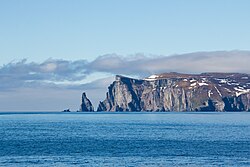
 The island as seen approaching from the east | |
| Geography | |
|---|---|
| Location | Winivere Bay |
| Area | 30.43 km2 (11.75 sq mi) |
| Length | 9.42 km (5.853 mi) |
| Width | 3.23 km (2.007 mi) |
| Highest elevation | 452 m (1,483 ft) |
| Highest point | Si'aati'shaa |
| Administration | |
| Demographics | |
| Population | 42 (2021) Population consists of semi-permanent researchers and ecologists. |
Anirniq (Awasi: /ænjɪrnjiːk/) is an island in Winivere Bay and the only island territory held by Awasin. It is believed to have been discovered by Kaal'ga Jaad explorers in the ninth century and was inhabited by Ch'iyakem peoples from the tenth through the fourteenth centuries. Its name is a loanword from a northern language family term of the same name. Though mapped in 1696, it was not officially recognized as Awasi territory until 1886.
Due to its location within the bay and distance from the mainland the island was the site of a permanently-manned military installation from 1887 to 1963. It was demilitarized by 1965 and converted to its present state as a nature reserve, though various corporations and private interests have attempted to lobby for mining and whaling rights. As of 2021 the sole settlement on the island is a government research station on the island's western cliffs.
History
Anirniq was discovered and inhabited sequentially by multiple coastal peoples from modern-day Awasin, forming the Daag'niaa culture. Remnants of seasonal settlements and deep-water canoes have been found in a cave dating to 1230-1570 CE. The Jaad name for the island is Jai'itt'agahdaw, which means 'island of cold rock.' Early Umbier explorer Coenraad Thanhoren sighted the island on his second expedition in the bay. Further exploration followed in 1699 and 1701 with much consideration given to the rich population of seabirds and southernly seals. From the early eighteenth century it was used as a base for fishing expeditions and seal hunts. Eggs of seabirds were harvested on regular bases until 1951.
Several settlements were constructed on the island in the 1750s, though none lasted longer than two winters owing to a lack of funding and declining availability of natural resources. The largest of these, Siiskutla, remains well-preserved on the beach of a northwestern inlet. Political upheaval and military presence on the mainland caused interest in Anirniq to dwindle until the newly-formed nation of Awasin declared the island an important strategic asset. Construction on a military base began in 1900, and by 1925 the island was home to just over 300 personnel.
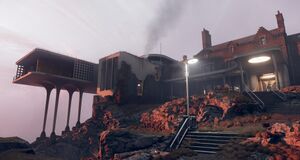
Environmental treaties and protection acts recognized in the late 1940s prompted a transitioning of many permanent outposts to research duties, as well as a renewed focus on part of Sikimiohkitopii I regarding demilitarization. Anirniq was declared a transitionary zone in 1950. The island was mostly depopulated and removed of military equipment by 1962, though a small contingent of researchers and officers remained to protect the area in the interim until economic interest could be safely rebuffed. The base and surrounding village was converted to a research station, Sdal'aan, in 1968 which is today the only populated region on the island. The station contains landing platforms for use by government helicopters and private ecological groups. It is recognized as a unique example of Awasi fusion architecture, with numerous buildings in a distinctly Arthuristan style.
Multiple post-secondary trips and climatological studies are carried out on a biyearly basis. The largest of these is the Otsskoimitaa University's seabird study, first undertaken in 2002. Amateur radio operators have conducted private expeditions with aid from the Awasi government in recent summers.
Geography
Hydrography
Awasi government agencies have conducted hydrographic surveys of waters around Anirniq throughout the 20th century. These were conducted first by the Moh'toya'omakawakin in 1922 and its successor, the Awasi Hydrographic Institute, from 1968 on. Water depths near the island and to the south and east do not generally exceed 90 meters (295 ft), but become much greater to the west, and especially 45 kilometers (24 nautical miles) to the north, where the shelf of the bay slopes off into much deeper water.
The island lowland contains only two freshwater lakes covering about 4 square kilometers (1.5 sq mi) in all. Several streams flow into the ocean, with multiple waterfalls along the northwestern coast. The northern third of the island is home to multiple small glaciers.

