User:Luziyca/Sandbox: Difference between revisions
No edit summary |
|||
| (237 intermediate revisions by 2 users not shown) | |||
| Line 1: | Line 1: | ||
{{Infobox | {{WIP}}{{Infobox flag | ||
| Name = Surrow | |||
| Article = | |||
| Image = File:Surrow_Flag.png | |||
| Noborder = | |||
| Nickname = | |||
| Morenicks = | |||
| Use = 111000 | |||
| Symbol = <!-- |Use="6-digit FIAV usage code" is required. --> | |||
| Proportion = 5:8 | |||
| Adoption = 1916 | |||
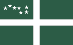
| Design = A centred white [[Tyrnican cross]] on a Rythenean green field with the {{wp|Big Dipper}} on the canton | |||
}} | }} | ||
The '''flag of [[Surrow]]''' is the {{wp|national flag}} of Surrow. Designed in 1891 by [[Ervin Suchet]], it was adopted in 1916 after Surrow gained full {{wp|self-government}} from [[Rythene]] by the [[Parliament of Surrow|Surrowese Parliament]] the previous year over the [[#Red ensign|red ensign]] previously used until 1916, or [[Joerg Angstroem]]'s [[#Surrowese Tricolor|tricolor]], and retained its status as Surrow's flag after its independence from Rythene in 1950. | |||
==Design== | |||
The flag is comprised of a centred white [[Tyrnican cross]] on a Rythenean green field, with the {{wp|Big Dipper}} on the canton. | |||
When the flag was designed by [[Ervin Suchet]] in 1891, the flag was made similar to the [[Flag of Rythene|Rythenean flag]] of that time, with Suchet declaring in a pamphlet which saw the flag be distributed that the green was to "symbolise our islands' indisputable Rythenean heritage," white "for the purity of the souls who inhabit this far northern land," the cross representing both "the [[Perendism#Symbols|Sword of Perende]] spreading civilisation" to the [[Native Surrowese]] and Surrow's "indisputable Rythenean heritage," and the Big Dipper "representing our land being the closest to the {{wp|North Pole}}." Suchet did not include any red in the flag design as he claimed that "no Surrowese blood has ever been spilled in any war." | |||
However, per the [[Constitution of Surrow]], the green is meant to symbolise Surrow's {{wp|krummholz|tuckamore}} forests that cover much of [[Holcot Island]], the white is meant to symbolise the long winters that Surrow experiences, the cross is meant to symbolise Surrow's democratic traditions, and the Big Dipper is meant to represent Surrow's geographic position as the northernmost nation of [[Maurceania Major]]. | |||
The | ==Historic flags== | ||
===Red ensign=== | |||
[[File:Surrowese_red_ensign.png|250px|thumb|left|Red ensign]] | |||
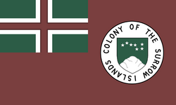
The first Surrowese flag was adopted in 1859, when the Rythenean government granted the Colony of Surrow the right to have its own {{wp|civil ensign}} to be used by Surrowese civilian boats. The Surrowese red ensign is comprised of the Rythenean {{wp|red ensign}}, with the Rythenean flag in the canton, and the [[Coat of arms of Surrow|colonial seal]], comprised of the shield of the [[Coat of arms of Surrow|Surrowese coat of arms]] surrounded by the text "Colony of the Surrow Islands" on a white disk in the fly half. | |||
The red ensign became associated with the Surrowese colonial government, and in 1866, the red ensign was declared by the Surrowese colonial government to be its {{wp|state ensign}}, allowing ships owned by the Surrowese government to use the red ensign. From the 1870s onward, the Surrowese red ensign was increasingly used on land by both the colonial government and by Surrowese civilians, and in 1886, the colonial government officially adopted the Surrowese red ensign as its official flag, "to be used in all circumstances where a local flag is deemed neccessary," although the Rythenean flag remained a co-official flag of Surrow. By the 1890s, the Surrowese red ensign became the only flag regularly flown at government buildings, with the Rythenean flag being consigned to military bases or at [[Government House, Holcot Inlet|Government Inlet]]. | |||
However, the Surrowese red ensign faced competition from both Suchet's flag and the Surrowese tricolor, leading to the Surrowese red ensign declining in popularity until it was replaced in 1916 with Suchet's flag design. The red ensign remained in use as a civil ensign until 1950, but by then, the red ensign has fallen into "virtually complete disuse" in favor of the Surrowese national flag. | |||
===Surrowese Tricolor=== | |||
[[File:Surrowese_Tricolour.png|250px|thumb|right|Surrowese Tricolor]] | |||
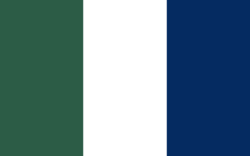
In 1887, [[Joerg Angstroem]] designed a green-white-blue {{wp|tricolor}} for the [[Fishermen's Protective Union (Surrow)|Fishermen's Protective Union]] as a party flag. According to Angstroem, green was meant to represent the Rythenean population, white was meant to represent Surrow's long winters, and blue was meant to represent the Tyrnican population, with Angstroem seeing the [[#Red ensign|red ensign]] used by the Surrowese government at the time as being "too Rythenean to be accepted by a sizable portion of the Surrowese population." | |||
Angstroem's flag became popular, with the flag being extensively promoted by the Fishermen's Protective Union throughout the late 1880s and early 1890s. By the mid-1890s, the Surrowese Tricolor became a popular flag, especially among Surrow's Tyrnican population. However, its rise in popularity among the Surrowese Tyrnican population led to a decline in the flag's popularity among Surrow's Rythenean population, especially in the context of the then-ongoing [[Surrowese language question]], with ethnic Rytheneans trending towards flying the red ensign, or towards Suchet's flag. This led to the Fishermen's Protective Union changing its flag in 1896 from the tricolor to a blue banner with a white fish. | |||
With the outbreak of the [[First Great War (Levilion)|First Great War]] in 1908, the colonial government banned the Surrowese tricolor as the colonial government feared that the flag could be used by "traitors who seek to bring Surrow back under the Tyrnican yoke." Although the flag was relegalized in 1913 after Tyrnica negotiated a separate peace with the Coalition, high levels of anti-Tyrnicanism at the time meant that the Surrowese Tricolor was not adopted by the Surrowese government in 1916, and the flag largely fell into disuse until the mid-1940s, when the [[Independence League (Surrow)|Independence League]] adopted the flag and used it to promote Surrowese independence, with leader [[Todd Lester]] proposing that the flag be adopted as the flag of an "independent Surrow." | |||
However, [[Ted Fisher]]'s decision to keep the current Surrowese flag led to the Surrowese Tricolor falling back into disuse. The Surrowese Tricolor would only see a revival in the mid-1980s, with [[Deacon Parker]]'s administration encouraging its use as a "secondary Surrowese flag," with a particular focus on touristic areas. Since then, the Surrowese Tricolor has become more popular, particularly in and around [[Holcot Inlet]] and [[Tern Harbour]]. | |||
==Gallery== | |||
Below are a list of flags used by the Surrowese government in the modern day. | |||
<gallery>Surrow_Flag.png|National flag | |||
Surrow_presidential_standard.png|Presidential standard | |||
Surrow_military_flag.png|Military flag | |||
Surrow_constabulary_flag.png|Constabulary flag</gallery> | |||
Latest revision as of 04:59, 16 December 2024
This article is incomplete because it is pending further input from participants, or it is a work-in-progress by one author. Please comment on this article's talk page to share your input, comments and questions. Note: To contribute to this article, you may need to seek help from the author(s) of this page. |
 | |
| Use | National flag |
|---|---|
| Proportion | 5:8 |
| Adopted | 1916 |
| Design | A centred white Tyrnican cross on a Rythenean green field with the Big Dipper on the canton |
The flag of Surrow is the national flag of Surrow. Designed in 1891 by Ervin Suchet, it was adopted in 1916 after Surrow gained full self-government from Rythene by the Surrowese Parliament the previous year over the red ensign previously used until 1916, or Joerg Angstroem's tricolor, and retained its status as Surrow's flag after its independence from Rythene in 1950.
Design
The flag is comprised of a centred white Tyrnican cross on a Rythenean green field, with the Big Dipper on the canton.
When the flag was designed by Ervin Suchet in 1891, the flag was made similar to the Rythenean flag of that time, with Suchet declaring in a pamphlet which saw the flag be distributed that the green was to "symbolise our islands' indisputable Rythenean heritage," white "for the purity of the souls who inhabit this far northern land," the cross representing both "the Sword of Perende spreading civilisation" to the Native Surrowese and Surrow's "indisputable Rythenean heritage," and the Big Dipper "representing our land being the closest to the North Pole." Suchet did not include any red in the flag design as he claimed that "no Surrowese blood has ever been spilled in any war."
However, per the Constitution of Surrow, the green is meant to symbolise Surrow's tuckamore forests that cover much of Holcot Island, the white is meant to symbolise the long winters that Surrow experiences, the cross is meant to symbolise Surrow's democratic traditions, and the Big Dipper is meant to represent Surrow's geographic position as the northernmost nation of Maurceania Major.
Historic flags
Red ensign
The first Surrowese flag was adopted in 1859, when the Rythenean government granted the Colony of Surrow the right to have its own civil ensign to be used by Surrowese civilian boats. The Surrowese red ensign is comprised of the Rythenean red ensign, with the Rythenean flag in the canton, and the colonial seal, comprised of the shield of the Surrowese coat of arms surrounded by the text "Colony of the Surrow Islands" on a white disk in the fly half.
The red ensign became associated with the Surrowese colonial government, and in 1866, the red ensign was declared by the Surrowese colonial government to be its state ensign, allowing ships owned by the Surrowese government to use the red ensign. From the 1870s onward, the Surrowese red ensign was increasingly used on land by both the colonial government and by Surrowese civilians, and in 1886, the colonial government officially adopted the Surrowese red ensign as its official flag, "to be used in all circumstances where a local flag is deemed neccessary," although the Rythenean flag remained a co-official flag of Surrow. By the 1890s, the Surrowese red ensign became the only flag regularly flown at government buildings, with the Rythenean flag being consigned to military bases or at Government Inlet.
However, the Surrowese red ensign faced competition from both Suchet's flag and the Surrowese tricolor, leading to the Surrowese red ensign declining in popularity until it was replaced in 1916 with Suchet's flag design. The red ensign remained in use as a civil ensign until 1950, but by then, the red ensign has fallen into "virtually complete disuse" in favor of the Surrowese national flag.
Surrowese Tricolor
In 1887, Joerg Angstroem designed a green-white-blue tricolor for the Fishermen's Protective Union as a party flag. According to Angstroem, green was meant to represent the Rythenean population, white was meant to represent Surrow's long winters, and blue was meant to represent the Tyrnican population, with Angstroem seeing the red ensign used by the Surrowese government at the time as being "too Rythenean to be accepted by a sizable portion of the Surrowese population."
Angstroem's flag became popular, with the flag being extensively promoted by the Fishermen's Protective Union throughout the late 1880s and early 1890s. By the mid-1890s, the Surrowese Tricolor became a popular flag, especially among Surrow's Tyrnican population. However, its rise in popularity among the Surrowese Tyrnican population led to a decline in the flag's popularity among Surrow's Rythenean population, especially in the context of the then-ongoing Surrowese language question, with ethnic Rytheneans trending towards flying the red ensign, or towards Suchet's flag. This led to the Fishermen's Protective Union changing its flag in 1896 from the tricolor to a blue banner with a white fish.
With the outbreak of the First Great War in 1908, the colonial government banned the Surrowese tricolor as the colonial government feared that the flag could be used by "traitors who seek to bring Surrow back under the Tyrnican yoke." Although the flag was relegalized in 1913 after Tyrnica negotiated a separate peace with the Coalition, high levels of anti-Tyrnicanism at the time meant that the Surrowese Tricolor was not adopted by the Surrowese government in 1916, and the flag largely fell into disuse until the mid-1940s, when the Independence League adopted the flag and used it to promote Surrowese independence, with leader Todd Lester proposing that the flag be adopted as the flag of an "independent Surrow."
However, Ted Fisher's decision to keep the current Surrowese flag led to the Surrowese Tricolor falling back into disuse. The Surrowese Tricolor would only see a revival in the mid-1980s, with Deacon Parker's administration encouraging its use as a "secondary Surrowese flag," with a particular focus on touristic areas. Since then, the Surrowese Tricolor has become more popular, particularly in and around Holcot Inlet and Tern Harbour.
Gallery
Below are a list of flags used by the Surrowese government in the modern day.


