Hope Province: Difference between revisions
Jump to navigation
Jump to search
(Created page with "{{Infobox political division | name = Hope Province | native_name = {{small|''Hoop Provinsie'' ({{wpl|Afrikaans|Asteriaans}})<br>''Hoop Provincie'' ({{w...") |
m (link) |
||
| (3 intermediate revisions by the same user not shown) | |||
| Line 58: | Line 58: | ||
| ethnic_groups = | | ethnic_groups = | ||
| religion = | | religion = | ||
| demonym = {{hlist|[[Hope Province#people|Hopers]]| | | demonym = {{hlist|[[Hope Province#people|Hopers]]|Henchies (colloquial)}} | ||
| admin_center_type = Administration | | admin_center_type = Administration | ||
| admin_center = [[Satavia#Administrative divisions|76 districts]] | | admin_center = [[Satavia#Administrative divisions|76 districts]] | ||
| Line 127: | Line 127: | ||
}} | }} | ||
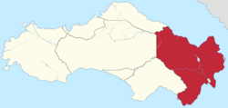
The '''Hope Province''' (commonly abbreviated '''HP''') is a [[Satavia#Administrative divisions|province]] occupying the eastern coast of Satavia. It is bordered to the east by the [[Van Horn Strait]], to the south-east by the [[Port Hope|National Capital District]], south-west by the [[Pioneerstaat]], west by the [[Central Territory]] and the north-west by the [[Orange Province]]. With a total land area of 141,622 square kilometres it is the largest{{Refn|group="N"|The Central Territory - itself not a province - is however larger still, occupying 204,198 square kilometres, or just over 1/3 of Satavia's total land area}} and most populous province. Its capital and largest city is [[Burnaby]]. | The '''Hope Province''' (commonly abbreviated '''HP''') is a [[Satavia#Administrative divisions|province]] occupying the eastern coast of [[Satavia]]. It is bordered to the east by the [[Van Horn Strait]], to the south-east by the [[Port Hope|National Capital District]], south-west by the [[Pioneerstaat]], west by the [[Central Territory]] and the north-west by the [[Orange Province]]. With a total land area of 141,622 square kilometres it is the largest{{Refn|group="N"|The Central Territory - itself not a province - is however larger still, occupying 204,198 square kilometres, or just over 1/3 of Satavia's total land area}} and most populous province. Its capital and largest city is [[Burnaby]]. | ||
==Notes== | |||
{{reflist|group=N}} | |||
[[Category:Provinces and territories of Satavia]] | |||
[[Category:Hope Province]] | |||
Latest revision as of 10:29, 12 August 2023
Hope Province Hoop Provinsie (Asteriaans) Hoop Provincie (Hennish) | |
|---|---|
Nickname(s):
| |
 Location of the Hope Province in Satavia | |
| Country | Satavia |
| Before federation | Dolphin Bay Colony |
| Settlement | 22 August 1541 |
| Ceded to Estmere | 1 July 1747 |
| Responsible government | 23 June 1813 |
| Federation | 1 October 1816 |
| Cession of Port Hope | 1 January 1999 |
| Founded by | Jan van Breybach |
| Capital and largest city | Burnaby |
| Administration | 76 districts |
| Official languages | |
| Demonym(s) |
|
| Government | |
• Governor | Johan de Vilock |
• Premier | Walter Mackenzie |
| Legislature | Parliament of the Hope Province |
| Parliament of Satavia | |
• Senate | 12 senators (of 96) |
| 42 seats (of 152) | |
| Area | |
• Total | 141,622 km2 (54,681 sq mi) (2nd) |
| Population | |
• 2022 census | 6,694,196 (1st) |
• Density | 47.27/km2 (122.4/sq mi) (5th) |
| ISO 3166 code | SV-HP |
| Website | hp |
The Hope Province (commonly abbreviated HP) is a province occupying the eastern coast of Satavia. It is bordered to the east by the Van Horn Strait, to the south-east by the National Capital District, south-west by the Pioneerstaat, west by the Central Territory and the north-west by the Orange Province. With a total land area of 141,622 square kilometres it is the largest[N 1] and most populous province. Its capital and largest city is Burnaby.
Notes
- ↑ The Central Territory - itself not a province - is however larger still, occupying 204,198 square kilometres, or just over 1/3 of Satavia's total land area

