|
|
| (27 intermediate revisions by the same user not shown) |
| Line 1: |
Line 1: |
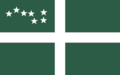
| {{Infobox ethnic group | | {{WIP}}{{Infobox flag |
| |group = Imaguan Maroons | | | Name = Surrow |
| |image = [[File:Cimarrón.JPG|250px]] | | | Article = |
| |caption = Depiction of a Maroon | | | Image = File:Surrow_Flag.png |
| |population = | | | Noborder = |
| |region1 = {{flag|Imagua and the Assimas}} | | | Nickname = |
| |langs = {{wp|African languages|Bahian languages}}, [[Western Imaguan Creole]], [[Eastern Imaguan Creole]] | | | Morenicks = |
| |rels = {{wp|Christianity|Sotirianity}}
| | | Use = 111000 |
| |related =
| | | Symbol = <!-- |Use="6-digit FIAV usage code" is required. --> |
| | | Proportion = 5:8 |
| | | Adoption = 1916 |
| | | Design = A centred white [[Tyrnican cross]] on a Rythenean green field with the {{wp|Big Dipper}} on the canton |
| }} | | }} |
| The '''Maroons''' ({{wp|Italian language|Etrurian}}: ''Marroni'') were escaped [[Bahio-Imaguan people|Bahian]] slaves who freed themselves from slavery in [[Imagua]] and established themselves in the [[Central Highlands (Imagua)|Central Highlands]] of [[Imagua (island)|Imagua]] from the mid-fifteenth century until the abolition of slavery at the end of the eighteenth century. While the term can also be applicable to the Maroons on the smaller [[Assimas Islands]], the Maroon populations were significantly smaller and less documented than the Maroons on the island of Imagua.
| |
|
| |
|
| ==Early history==
| | The '''flag of [[Surrow]]''' is the {{wp|national flag}} of Surrow. Designed in 1891 by [[Ervin Suchet]], it was adopted in 1916 after Surrow gained full {{wp|self-government}} from [[Rythene]] by the [[Parliament of Surrow|Surrowese Parliament]] the previous year over the [[#Red ensign|red ensign]] previously used until 1916, or [[Joerg Angstroem]]'s [[#Surrowese Tricolor|tricolor]], and retained its status as Surrow's flag after its independence from Rythene in 1950. |
| ===Origins===
| |
| From the start of [[Caldia|Caldish]] colonisation, escaped slaves on the island of [[Imagua (island)|Imagua]] (at this time [[Native Imaguan people|Native Imaguans]]) would flee to areas with low white settlement, with this trend continuing during [[Blostland|Blostlandic]] rule of Imagua, with escaped slaves captured in present-day [[Eldmark]] fleeing into the [[Central Highlands (Imagua)|Central Highlands]]. These escaped slaves would form the basis of the Maroon community, with archaeological evidence suggesting that there were around 28 sites in the [[Nearon Valley]] associated with "indigenous Maroons" between 1550 and 1650.
| |
|
| |
|
| With the seizure of Imagua by [[Estmere]] in 1658, Estmerish settlers not only encroached on the Maroon communities in the Glen Valley, but brought Bahian slaves as part of the [[Transvehemens slave trade|triangle trade]] to work on {{wp|sugar}} or {{wp|nutmeg}} plantations. Due to their short life expectancy and brutal working conditions, many slaves on the island of Imagua would escape to the Central Highlands, where they would intermingle with the indigenous Asterians who fled decades earlier, and create a distinct Maroon society.
| | ==Design== |
| | The flag is comprised of a centred white [[Tyrnican cross]] on a Rythenean green field, with the {{wp|Big Dipper}} on the canton. |
|
| |
|
| Maroons were able to survive by {{wp|subsistence farming}} and through raiding nearby plantations. Initially, early Maroon governance bore stark similarities to the [[Sâre|village system]] practiced in [[Bahia]], with {{wp|direct democracy}} being practiced by Maroon communities, with a chieftain being in charge of a Maroon community.
| | When the flag was designed by [[Ervin Suchet]] in 1891, the flag was made similar to the [[Flag of Rythene|Rythenean flag]] of that time, with Suchet declaring in a pamphlet which saw the flag be distributed that the green was to "symbolise our islands' indisputable Rythenean heritage," white "for the purity of the souls who inhabit this far northern land," the cross representing both "the [[Perendism#Symbols|Sword of Perende]] spreading civilisation" to the [[Native Surrowese]] and Surrow's "indisputable Rythenean heritage," and the Big Dipper "representing our land being the closest to the {{wp|North Pole}}." Suchet did not include any red in the flag design as he claimed that "no Surrowese blood has ever been spilled in any war." |
|
| |
|
| ===Formation of the Westward and Eastward Maroons===
| | However, per the [[Constitution of Surrow]], the green is meant to symbolise Surrow's {{wp|krummholz|tuckamore}} forests that cover much of [[Holcot Island]], the white is meant to symbolise the long winters that Surrow experiences, the cross is meant to symbolise Surrow's democratic traditions, and the Big Dipper is meant to represent Surrow's geographic position as the northernmost nation of [[Maurceania Major]]. |
| Beginning in the 1670s, slave uprisings became more prevalent on the island of Imagua, due to the arrival of members of the warrior caste to Imagua, under the belief that their fitness would make them more likely to survive the harsh conditions of sugar production.
| |
|
| |
|
| The most notable uprising during this period was in 1681, when the Parlow estate faced an uprising of around 800 slaves, with most of the slaves fleeing to the Central Highlands, where they would establish a town in present-day [[Lethbridge, Imagua and the Assimas|Lethbridge]]. There, they coalesced around [[Chepiri Parlow]], who established a [[Hourege|Houregic]] polity around the town. Although Chepiri was killed in battle in 1683, and many of the slaves were recaptured when their settlement was captured, 300 were able to "evade their owners," and formed their own community in the Central Highlands. The Chepiri Maroons would become dominant among many Maroon communities, with Chepiri's successor, [[Queen Ruwa]] coalescing most of the Maroon communities on the western slopes of the Glen Valley into what would become the Westward Maroons. | | ==Historic flags== |
| | ===Red ensign=== |
| | [[File:Surrowese_red_ensign.png|250px|thumb|left|Red ensign]] |
| | The first Surrowese flag was adopted in 1859, when the Rythenean government granted the Colony of Surrow the right to have its own {{wp|civil ensign}} to be used by Surrowese civilian boats. The Surrowese red ensign is comprised of the Rythenean {{wp|red ensign}}, with the Rythenean flag in the canton, and the [[Coat of arms of Surrow|colonial seal]], comprised of the shield of the [[Coat of arms of Surrow|Surrowese coat of arms]] surrounded by the text "Colony of the Surrow Islands" on a white disk in the fly half. |
|
| |
|
| On the eastern slopes of the Glen Valley, 300 slaves escaped from several plantations near [[Happy Valley]] into the Central Highlands during a slave revolt in 1689. Unlike the Westward Maroons, which was significantly organised along Houregic lines, the Eastward Maroon communities created as a result of the 1689 slave revolt were decentralised and never coalesced into Hourege-style polities, instead following a model most similar to the [[Sare|village system]].
| | The red ensign became associated with the Surrowese colonial government, and in 1866, the red ensign was declared by the Surrowese colonial government to be its {{wp|state ensign}}, allowing ships owned by the Surrowese government to use the red ensign. From the 1870s onward, the Surrowese red ensign was increasingly used on land by both the colonial government and by Surrowese civilians, and in 1886, the colonial government officially adopted the Surrowese red ensign as its official flag, "to be used in all circumstances where a local flag is deemed neccessary," although the Rythenean flag remained a co-official flag of Surrow. By the 1890s, the Surrowese red ensign became the only flag regularly flown at government buildings, with the Rythenean flag being consigned to military bases or at [[Government House, Holcot Inlet|Government Inlet]]. |
|
| |
|
| By 1700, it was estimated that there were around a thousand Maroon communities around the Glen Valley, split roughly evenly between the Westward and Eastward Maroons. Furthermore, some evidence emerged of Maroon communities along the northern slopes of [[Mount Apita]], with one community which numbered 60 individuals being completely buried in the 1694 eruption of Mount Apita, as well as some Maroon communities along the southern slopes of [[Mount Guanara]]. However, compared to the Maroons around the Glen Valley, these Maroon communities were minor, and never coalesced into a major organisational grouping compared to the Westward and Eastward Maroons.
| | However, the Surrowese red ensign faced competition from both Suchet's flag and the Surrowese tricolor, leading to the Surrowese red ensign declining in popularity until it was replaced in 1916 with Suchet's flag design. The red ensign remained in use as a civil ensign until 1950, but by then, the red ensign has fallen into "virtually complete disuse" in favor of the Surrowese national flag. |
|
| |
|
| ==Heyday of the Maroons== | | ===Surrowese Tricolor=== |
| ===Ten Years' War and Gaullican rule===
| | [[File:Surrowese_Tricolour.png|250px|thumb|right|Surrowese Tricolor]] |
| [[File:Maroons_preparing_to_ambush_a_convoy.jpg|250px|thumb|right|Painting of a raid during [[Oparo's Rebellion]], 1810]] | | In 1887, [[Joerg Angstroem]] designed a green-white-blue {{wp|tricolor}} for the [[Fishermen's Protective Union (Surrow)|Fishermen's Protective Union]] as a party flag. According to Angstroem, green was meant to represent the Rythenean population, white was meant to represent Surrow's long winters, and blue was meant to represent the Tyrnican population, with Angstroem seeing the [[#Red ensign|red ensign]] used by the Surrowese government at the time as being "too Rythenean to be accepted by a sizable portion of the Surrowese population." |
| During the [[Ten Years' War]] between [[Gaullica]] and [[Estmere]], as word spread inland of Gaullica's attack on Estmere, the Westward Maroons led by Queen Ruka, as well as some villages among the Eastward Maroons started to believe that Gaullica would bring them freedom from the "chains of slavery," and that if they fought against the Estmerish, that they would be able to be free.
| |
|
| |
|
| Thus, in 1711, Queen Ruwa launched [[Queen Ruwa's Rebellion]] against the Estmerish. While Queen Ruwa died in 1713, she was succeeded by [[King Conlan]], who develops tactics to "wear and tire" the Estmerish forces defending the island, allowing the Westward Maroons to raid and burn several settlements, most notably [[Altaithe]] in 1716, while liberating slaves from plantations and incorporating them into the Maroon community.
| | Angstroem's flag became popular, with the flag being extensively promoted by the Fishermen's Protective Union throughout the late 1880s and early 1890s. By the mid-1890s, the Surrowese Tricolor became a popular flag, especially among Surrow's Tyrnican population. However, its rise in popularity among the Surrowese Tyrnican population led to a decline in the flag's popularity among Surrow's Rythenean population, especially in the context of the then-ongoing [[Surrowese language question]], with ethnic Rytheneans trending towards flying the red ensign, or towards Suchet's flag. This led to the Fishermen's Protective Union changing its flag in 1896 from the tricolor to a blue banner with a white fish. |
|
| |
|
| Following the cession of Imagua to Gaullica in 1721, King Conlan would negotiate a treaty with the Gaullicans in 1723 where the Westward Maroons were granted some land, comprised of seven towns, including Chepiri Town, in exchange for the Westward Maroons no longer admitting any new Maroons into their communities, and cooperating with the Gaullican authorities to crush slave revolts.
| | With the outbreak of the [[First Great War (Levilion)|First Great War]] in 1908, the colonial government banned the Surrowese tricolor as the colonial government feared that the flag could be used by "traitors who seek to bring Surrow back under the Tyrnican yoke." Although the flag was relegalized in 1913 after Tyrnica negotiated a separate peace with the Coalition, high levels of anti-Tyrnicanism at the time meant that the Surrowese Tricolor was not adopted by the Surrowese government in 1916, and the flag largely fell into disuse until the mid-1940s, when the [[Independence League (Surrow)|Independence League]] adopted the flag and used it to promote Surrowese independence, with leader [[Todd Lester]] proposing that the flag be adopted as the flag of an "independent Surrow." |
|
| |
|
| However, among the Eastward Maroons, while some were willing to cooperate with the Gaullicans, many Eastward Maroon villages were less willing to cooperate with the Gaullicans. Thus, when a slave revolt broke out in 1734 at the Fanshaw estate, many Eastward Maroons cooperated with the slaves, while the Westward Maroons under King Conlan were sent to crush the slave revolt, doing so successfully, although 41 slaves would avoid capture by the Westward Maroons and Gaullican militiamen. | | However, [[Ted Fisher]]'s decision to keep the current Surrowese flag led to the Surrowese Tricolor falling back into disuse. The Surrowese Tricolor would only see a revival in the mid-1980s, with [[Deacon Parker]]'s administration encouraging its use as a "secondary Surrowese flag," with a particular focus on touristic areas. Since then, the Surrowese Tricolor has become more popular, particularly in and around [[Holcot Inlet]] and [[Tern Harbour]]. |
|
| |
|
| In 1742, King Conlan died, and the Westward Maroons split in two, with Conlan's son, [[Acon Conlan]], remaining loyal to Gaullica, and Conlan's first cousin once removed, [[Oparo Smith]], who was more sympathetic to the Estmerish and with the Eastern Maroons. Thus, in 1744, Oparo Smith launched [[Oparo's Rebellion]], rebelling against Gaullican rule. Oparo made some gains early on, to the point of taking over Chepiri Town by 1746, but the combined support of Gaullican soldiers, forces loyal to Acon Conlan, and the Gaullican-aligned villages among the Eastern Maroons meant that by 1749, Oparo was killed in battle, and Oparo's Rebellion came to an end.
| | ==Gallery== |
| | Below are a list of flags used by the Surrowese government in the modern day. |
|
| |
|
| However, in response to Oparo's Rebellion, the rights of the Westward Maroons were reduced, with Ruwa Town (near [[Ballavagg]]), where Oparo lived, being depopulated, and its inhabitants sold back into slavery. Furthermore, Gaullican officials were sent to live in the remaining six towns of the Westward Maroons, in an effort to "quell any signs of rebellion" before they occur, which eroded the autonomy of the Westward Maroons.
| | <gallery>Surrow_Flag.png|National flag |
| | | Surrow_presidential_standard.png|Presidential standard |
| By 1752, Gaullican officials recorded that 3,219 Maroons lived in the six towns governed by Acon Conlan. At the same time, it is estimated that of the 80-90 communities among the Eastward Maroons, around two thousand Maroons inhabited these communities, although poor documentation of the Eastward Maroons, and the lack of treaties between the Gaullican authorities and Eastward Maroons meant that it is difficult to gather numbers.
| | Surrow_military_flag.png|Military flag |
| | | Surrow_constabulary_flag.png|Constabulary flag</gallery> |
| During the 1750s, the Eastward Maroons, realising that their divisions would allow Gaullicans and the Westward Maroons to exploit them for their own gain, began to coalesce into a unified entity. Unlike the Westward Maroons, who adopted a Houregic system, the Eastward Maroons would have each of their villages elect a delegate to serve on a council, who would elect a headman to assert the rights of the Eastward Maroons. This position was held by [[Gideon Bohannon]].
| |
| | |
| In 1762, Gideon Bohannon would launch [[Gideon's Rebellion]], with Gideon Bohannon seeking to either create "an independent state" or acquiring concessions from the Gaullicans. Improving on the tactics used by King Conlan and Oparo Smith, Gideon Bohannon was able to carve out an area where the Eastward Maroons could govern themselves, while liberating slaves. The Westward Maroons, who were sent to crush the rebellion, were unable to effectively quell the rebellion, and by 1764, with the outbreak of the [[Asterian War of Secession]], and Gideon's success on the battlefield, the Gaullicans were forced to give the Eastward Maroons the same privileges that they gave the Westward Evaedees, with the Eastward Maroons being granted twelve towns in their territory to govern autonomously, in exchange for no longer allowing new Maroons to join, and allowing Gaullican officials to base themselves in the towns.
| |
| | |
| During the Asterian War of Seccession, both the Westward and Eastward Maroons fought alongside the Gaullicans to defend Imagua from Estmere, as both feared that the Estmerish would take away their rights and privileges. In 1768, Acon Conlan died, and was succeeded by [[Isay Conlan]] as leader of the Westward Maroons.
| |
| | |
| ===Final years of slavery===
| |
| Following the return of the Colony of Imagua to [[Estmere]] in 1771, the agreements between the colonial government and the Westward and Eastward Maroons were abrogated the following year, as the colonial government saw these Maroon governments as being "imposed by the Gaullicans." This meant that overnight, the Maroons' ability to govern their own communities were taken away from them, while their legal status became unclear.
| |
| | |
| Some Maroon communities would flee deeper into the [[Central Highlands]], in an effort to avoid {{wp|slave catchers}}. Others began engaging in active resistance against the Estmerish colonial government, culminating in the 1774 [[Isay Rebellion]], led by [[Isay Conlan]]. Unlike past rebellions, the Isay Rebellion involved both the Westward and Eastward Maroons, with Isay Conlan developing an alliance with [[Gideon Bohannon]]. Isay Conlan primarily served as the political leader, while Gideon Bohannon served as the military leader of the Isay Rebellion.
| |
| | |
| At its height in 1775, the Isay Rebellion controlled much of the Central Highlands and the Upper Glen Valley, but after the defeat of Isay rebels at the [[Battle of New Burdale]] in late 1775, in part due to increased reinforcements by Estmere, Isay Conlan and Gideon Bohannon's forces saw mounting losses until they were forced to surrender in 1777.
| |
| | |
| Both Isay Conlan and Gideon Bohannon were executed for treason in 1778, but with the rising abolitionist tide, there was pressure to settle the status of the Maroons. Thus, in 1780, the colonial government declared that all "escaped slaves currently in the Central Highlands" were {{wp|freedman|freemen}} "with all rights thereof." However, this only covered the existing Maroon communities, and did not affect those who escaped into the highlands after that date.
| |
| | |
| Some Maroons were critical of that decision, as it did not restore their autonomy that they had under the Gaullicans, while a few communities committed {{wp|mass suicide}} out of fear that Estmerish officials sent to inform the Maroons of that decision were actually slave catchers trying to bring them back into slavery. However, most Maroons would leave the Central Highlands after the 1780 decree, and would eventually assimilate into the [[Bahio-Imaguan people|Bahio-Imaguan community]] after a few generations. Thus, of the eighteen Maroon towns that existed in 1780, only two remained by the time slavery was abolished: Chepiri Town, belonging to the Westward Maroons, and Bohannon Town (in present-day TBD), belonging to the Eastward Maroons.
| |
| | |
| ==Decline and demise==
| |
| ===Post-slavery and decline===
| |
| By the time slavery was abolished in 1795, it was estimated that there were around one to three thousand Maroons remaining in the Central Highlands, roughly evenly split between the Westward and Eastward Maroons, with Estmerish officials sent to inform the Maroons that slavery was abolished in its entirety recording thirty-nine villages inhabited by Maroons, with a population of "no more than one thousand."
| |
| | |
| With the abolition of slavery, Maroons no longer needed to hide in the Central Highlands in order to escape slavery. This led to a substantial decline of the Maroon population residing in the Central Highlands, and the abandonment of most of the Maroon villages: by 1811, [[Wyatt Millard]] only recorded two Eastward Maroon villages "high on the eastern slopes of the Glen Valley," with one having a population of 19 people, and the other with a population of 11 people. Millard subsequently recorded six Westward Maroon villages in 1813, "each with a population of around 50 people." In both of these expeditions, Millard noted that the Maroon populations were declining, with those staying "generally being older people who knew little about modern life."
| |
| | |
| During the early nineteenth century, the Maroon populations remaining in the Central Highlands were generally left alone by the colonial government, due to financial considerations, although Millard advocated for relocating the Maroons remaining in the Central Highlands to [[Lethbridge, Imagua and the Assimas|Lethbridge]] to "integrate them into Imaguan society." This policy of neglect saw the remaining Maroon villages slowly decline: by 1850, only four Maroon villages remained, all of them concentrated on the western slopes of the Glen Valley, and by 1870, only two Maroon villages remained, with both villages reporting to "have the same governance that the Eastward Maroons had a mere century ago."
| |
| | |
| ===Demise===
| |
| In 1871, [[Richard Sweet]] visited the two remaining Maroon villages in order to gather demographic data for the 1871 census. Sweet found that the population of what he called "North Village" was at 13 people, and the population at what he called "South Village" was at 11 people, and noted that the average age of the population in both Maroon villages was around 51 years, "and increasing as the average villager dies out." Sweet also observed that "in the North Village, there were only three children, and in the South Village, there was only one child," and that "based on the continued demographic trends, it is unlikely that these villages will survive the next century."
| |
| | |
| Sweet's report aroused the interest of the colonial government, and in 1873, Sweet was sent back to persuade the remaining Maroons to abandon their villages and move to Lethbridge where they could be "properly acclimated into modern civilisation." Although Sweet attempted to persuade the Maroons by promising them land near Chepiri Town (Lethbridge), where they could continue to live together "in a village-like setting," both villages rejected Sweet's proposal, with the chief of North Village reporting that he was "unwilling to give up [the Maroon's] safety, [their] freedom, and [their] culture"
| |
| | |
| Sweet would publish a report in 1875 detailing his efforts to try and persuade the remaining Maroons to abandon their villages, and documenting some of the cultural customs of the remaining Maroons, with Sweet observing that "both the North and South villages observe broadly similar customs that are rooted in Bahian culture," although the isolation of the two villages meant that "some of the customs, such as feasts and holidays, have different foods and different traditions." Sweet noted that since his initial visit in 1871, the populations of North Village and South Village fell to eleven and seven people respectively. Sweet concluded his report by saying that "it would be unnecessarily cruel to uproot the old men and women, who have spent their whole lives in their villages," but added that "for the three Maroon children, it is a necessity to send them to school down in Lethbridge so they may learn the skills needed to live outside the village."
| |
| | |
| Sweet's 1875 report was favourably received by the colonial government, and in 1876, the [[Royal Imaguan Constabulary|Imaguan Constabulary]] went to the villages to force the children in the villages to go to school in Lethbridge. This was met with significant resistance by those in the North Village, leading to
| |
| | |
| (TBC)
| |
The flag of Surrow is the national flag of Surrow. Designed in 1891 by Ervin Suchet, it was adopted in 1916 after Surrow gained full self-government from Rythene by the Surrowese Parliament the previous year over the red ensign previously used until 1916, or Joerg Angstroem's tricolor, and retained its status as Surrow's flag after its independence from Rythene in 1950.
Design
The flag is comprised of a centred white Tyrnican cross on a Rythenean green field, with the Big Dipper on the canton.
When the flag was designed by Ervin Suchet in 1891, the flag was made similar to the Rythenean flag of that time, with Suchet declaring in a pamphlet which saw the flag be distributed that the green was to "symbolise our islands' indisputable Rythenean heritage," white "for the purity of the souls who inhabit this far northern land," the cross representing both "the Sword of Perende spreading civilisation" to the Native Surrowese and Surrow's "indisputable Rythenean heritage," and the Big Dipper "representing our land being the closest to the North Pole." Suchet did not include any red in the flag design as he claimed that "no Surrowese blood has ever been spilled in any war."
However, per the Constitution of Surrow, the green is meant to symbolise Surrow's tuckamore forests that cover much of Holcot Island, the white is meant to symbolise the long winters that Surrow experiences, the cross is meant to symbolise Surrow's democratic traditions, and the Big Dipper is meant to represent Surrow's geographic position as the northernmost nation of Maurceania Major.
Historic flags
Red ensign
The first Surrowese flag was adopted in 1859, when the Rythenean government granted the Colony of Surrow the right to have its own civil ensign to be used by Surrowese civilian boats. The Surrowese red ensign is comprised of the Rythenean red ensign, with the Rythenean flag in the canton, and the colonial seal, comprised of the shield of the Surrowese coat of arms surrounded by the text "Colony of the Surrow Islands" on a white disk in the fly half.
The red ensign became associated with the Surrowese colonial government, and in 1866, the red ensign was declared by the Surrowese colonial government to be its state ensign, allowing ships owned by the Surrowese government to use the red ensign. From the 1870s onward, the Surrowese red ensign was increasingly used on land by both the colonial government and by Surrowese civilians, and in 1886, the colonial government officially adopted the Surrowese red ensign as its official flag, "to be used in all circumstances where a local flag is deemed neccessary," although the Rythenean flag remained a co-official flag of Surrow. By the 1890s, the Surrowese red ensign became the only flag regularly flown at government buildings, with the Rythenean flag being consigned to military bases or at Government Inlet.
However, the Surrowese red ensign faced competition from both Suchet's flag and the Surrowese tricolor, leading to the Surrowese red ensign declining in popularity until it was replaced in 1916 with Suchet's flag design. The red ensign remained in use as a civil ensign until 1950, but by then, the red ensign has fallen into "virtually complete disuse" in favor of the Surrowese national flag.
Surrowese Tricolor
In 1887, Joerg Angstroem designed a green-white-blue tricolor for the Fishermen's Protective Union as a party flag. According to Angstroem, green was meant to represent the Rythenean population, white was meant to represent Surrow's long winters, and blue was meant to represent the Tyrnican population, with Angstroem seeing the red ensign used by the Surrowese government at the time as being "too Rythenean to be accepted by a sizable portion of the Surrowese population."
Angstroem's flag became popular, with the flag being extensively promoted by the Fishermen's Protective Union throughout the late 1880s and early 1890s. By the mid-1890s, the Surrowese Tricolor became a popular flag, especially among Surrow's Tyrnican population. However, its rise in popularity among the Surrowese Tyrnican population led to a decline in the flag's popularity among Surrow's Rythenean population, especially in the context of the then-ongoing Surrowese language question, with ethnic Rytheneans trending towards flying the red ensign, or towards Suchet's flag. This led to the Fishermen's Protective Union changing its flag in 1896 from the tricolor to a blue banner with a white fish.
With the outbreak of the First Great War in 1908, the colonial government banned the Surrowese tricolor as the colonial government feared that the flag could be used by "traitors who seek to bring Surrow back under the Tyrnican yoke." Although the flag was relegalized in 1913 after Tyrnica negotiated a separate peace with the Coalition, high levels of anti-Tyrnicanism at the time meant that the Surrowese Tricolor was not adopted by the Surrowese government in 1916, and the flag largely fell into disuse until the mid-1940s, when the Independence League adopted the flag and used it to promote Surrowese independence, with leader Todd Lester proposing that the flag be adopted as the flag of an "independent Surrow."
However, Ted Fisher's decision to keep the current Surrowese flag led to the Surrowese Tricolor falling back into disuse. The Surrowese Tricolor would only see a revival in the mid-1980s, with Deacon Parker's administration encouraging its use as a "secondary Surrowese flag," with a particular focus on touristic areas. Since then, the Surrowese Tricolor has become more popular, particularly in and around Holcot Inlet and Tern Harbour.
Gallery
Below are a list of flags used by the Surrowese government in the modern day.