Taikorea Territory: Difference between revisions
Jump to navigation
Jump to search


No edit summary |
No edit summary |
||
| Line 41: | Line 41: | ||
Taikorea was home to [[Tangaran people|Tangaran]] populations as early as 4,000 years ago,. | Taikorea was home to [[Tangaran people|Tangaran]] populations as early as 4,000 years ago,. | ||
==Etymology== | |||
==History== | ==History== | ||
==Politics== | |||
===Government=== | |||
====Executive branch==== | |||
====Legislative branch==== | |||
[[File:San Francisco City Hall 2.JPG|350px|thumb|[[Robert E. Manting Territorial Council Building]] in [[Port Sistine]] is the seat of the [[Alexandria Territorial Council]].]] | |||
====Judicial branch==== | |||
==Demographics== | |||
{{Largest Cities in Taikorea Territory}} | |||
==Economy== | |||
[[File:Port of Los Angeles 2.png|350px|thumb|Sistine Harbor, located in [[Port Sistine]], is the largest harbor by import volume in Meridon and one of the principal ports in the country.]] | |||
===Agriculture=== | |||
===Industrial and Manufacturing=== | |||
===Government and Services=== | |||
==Infrastructure== | |||
===Energy=== | |||
===Transportation=== | |||
====Highways==== | |||
====Air travel==== | |||
====Rail==== | |||
====Water travel==== | |||
===Water=== | |||
==Geography== | ==Geography== | ||
<gallery> | |||
Kakadu (AU), Kakadu National Park, Nadap Lookout -- 2019 -- 4182.jpg|Weaver Federal Nature Reserve in TBD Northwestern Alexandria Territory. | |||
Cooplacurripa Station(5).jpg|A cattle station in southern Alexandria. | |||
</gallery> | |||
==Culture== | ==Culture== | ||
===Historical regions=== | |||
===Media and entertainment=== | |||
===Sports=== | |||
==See Also== | |||
===Territorial Maps=== | |||
<gallery> | |||
TKmap terrain.png|Terrain map | |||
TKmap_districtlinesonly.png|Districts | |||
TKmap districtlinescities.png|Districts and cities | |||
TKmap_terraindistrictlines.png|Districts and terrain | |||
TKmap_districtlinescitiesroads.png|Districts, cities, and roads | |||
TKmap_terraincitiesroads.png|Terrain, cities, and roads | |||
TKmap_all.png|Terrain, districts, cities, roads | |||
</gallery> | |||
{{Template:MeridonTopics}} | |||
[[Category:Meridon]] | [[Category:Meridon]] | ||
[[Category: Territories of Meridon]] | [[Category: Territories of Meridon]] | ||
Latest revision as of 15:51, 5 April 2024
Taikorea Territory | |
|---|---|
 Taikorea Territory | |
| Country | Meridon |
| Capital | Misanui |
| Largest city | Misanui |
| Territory | July 3, 1640 |
| Government | |
| • Taikorea Executive Council |
|
| Population | |
| • Total | 7,717,707 |
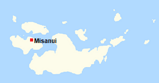
Taikorea is a territory of Meridon, comprising of Taikorea Island and its surrounding islands. It is bordered to the north by Kalua Territory, to the east by the Eastern Islands Territory, and to the west by Silvers Island Territory. Taikorea's capital and largest city is is Misanui.
Taikorea was home to Tangaran populations as early as 4,000 years ago,.
Etymology
History
Politics
Government
Executive branch
Legislative branch

Robert E. Manting Territorial Council Building in Port Sistine is the seat of the Alexandria Territorial Council.
Judicial branch
Demographics
Template:Largest Cities in Taikorea Territory
Economy

Sistine Harbor, located in Port Sistine, is the largest harbor by import volume in Meridon and one of the principal ports in the country.
Agriculture
Industrial and Manufacturing
Government and Services
Infrastructure
Energy
Transportation
Highways
Air travel
Rail
Water travel
Water
Geography
Culture
Historical regions
Media and entertainment
Sports
See Also
Territorial Maps
- TKmap terrain.png
Terrain map
- TKmap districtlinesonly.png
Districts
- TKmap districtlinescities.png
Districts and cities
- TKmap terraindistrictlines.png
Districts and terrain
- TKmap districtlinescitiesroads.png
Districts, cities, and roads
- TKmap terraincitiesroads.png
Terrain, cities, and roads
- TKmap all.png
Terrain, districts, cities, roads


