Finstria: Difference between revisions
Jump to navigation
Jump to search
(completely revamped it all to change it from a long-retconned country into a province ("yend") of a current country (Borland (in Kylaris, not the poser))) |
|||
| Line 1: | Line 1: | ||
{{wip}} | {{wip}} | ||
{{Infobox | |||
| | {{Infobox settlement | ||
|native_name = '' | |name = Finstria | ||
| | |native_name = ''Finstrië'' <small>([[Borish language|Borish]])</small><br>''Finstrien'' <small>([[wikipedia:German language|Weranian]])</small> | ||
| | |native_name_lang = <!-- ISO 639-1 code e.g. "fr" for French. If more than one, use {{lang}} instead --> | ||
| | |settlement_type = [[Administrative divisions of Borland (Kylaris)|Yend]] | ||
|image_skyline = | |||
| | |imagesize = | ||
| | |image_alt = | ||
| | |image_caption = | ||
| | |image_flag = Flag_of_Finstria.png | ||
| | |flag_alt = | ||
| | |image_seal = | ||
| | |seal_alt = | ||
| | |image_shield = | ||
| | |shield_alt = | ||
| | |etymology = | ||
| | |nickname = | ||
| | |motto = | ||
| | |image_map = Finstria.png | ||
| | |map_alt = | ||
| | |map_caption = Location of Finstria within [[Borland (Kylaris)|Borland]] | ||
| | |pushpin_map = | ||
| | |pushpin_map_alt = | ||
| | |pushpin_map_caption = | ||
| | |pushpin_label_position = | ||
| | |coordinates = <!-- {{coord|latitude|longitude|type:city|display=inline,title}} --> | ||
|leader_title1 = | |coor_pinpoint = | ||
|leader_name1 = | |coordinates_footnotes = | ||
|leader_title2 = | |subdivision_type = Country | ||
| | |subdivision_name = [[Borland (Kylaris)|Borland]] | ||
| | |subdivision_type1 = Largest city | ||
| | |subdivision_name1 = [[Werlaigh]] | ||
|subdivision_type2 = Administrative capital | |||
| | |subdivision_name2 = [[Syegaire]] | ||
| | |subdivision_type3 = | ||
| | |subdivision_name3 = | ||
| | |established_title1 = Founded | ||
| | |established_date1 = 1 July 1935 | ||
| | |founder = | ||
| | |seat_type = | ||
| | |seat = | ||
| | |government_footnotes = | ||
| | |government_type = | ||
| | |governing_body = | ||
| | |leader_party = | ||
| | |leader_title = | ||
| | |leader_name = | ||
| | |leader_title1 = | ||
| | |leader_name1 = | ||
| | |leader_title2 = | ||
| | |leader_name2 = | ||
| | |leader_title3 = | ||
| | |leader_name3 = | ||
|leader_title4 = | |||
|leader_name4 = | |||
|unit_pref = Metric | |||
<!-- ALL fields with measurements have automatic unit conversion --> | |||
<!-- for references: use <ref> tags --> | |||
|area_footnotes = | |||
|area_urban_footnotes = <!-- <ref> </ref> --> | |||
|area_rural_footnotes = <!-- <ref> </ref> --> | |||
|area_metro_footnotes = <!-- <ref> </ref> --> | |||
|area_magnitude = <!-- <ref> </ref> --> | |||
|area_note = | |||
|area_water_percent = | |||
|area_rank = | |||
|area_blank1_title = | |||
|area_blank2_title = | |||
<!-- square kilometers --> | |||
|area_total_km2 = | |||
|area_land_km2 = | |||
|area_water_km2 = | |||
|area_urban_km2 = | |||
|area_rural_km2 = | |||
|area_metro_km2 = | |||
|area_blank1_km2 = | |||
|area_blank2_km2 = | |||
<!-- hectares --> | |||
|area_total_ha = | |||
|area_land_ha = | |||
|area_water_ha = | |||
|area_urban_ha = | |||
|area_rural_ha = | |||
|area_metro_ha = | |||
|area_blank1_ha = | |||
|area_blank2_ha = | |||
|length_km = | |||
|width_km = | |||
|dimensions_footnotes = | |||
|elevation_footnotes = | |||
|elevation_m = | |||
|population_footnotes = | |||
|population_as_of = 2020 | |||
|population_total = 895,000 | |||
|population_density_km2 = auto | |||
|population_note = | |||
|population_demonym = | |||
|timezone1 = | |||
|utc_offset1 = | |||
|timezone1_DST = | |||
|utc_offset1_DST = | |||
|postal_code_type = [[wikipedia:Postal code|Postal codes]] (allocated) | |||
|postal_code = 60-00 to 69-99 | |||
|area_code_type = | |||
|area_code = | |||
|area_codes = for multiple area codes | |||
|iso_code = | |||
|website = <!-- {{URL|example.com}} --> | |||
|module = | |||
|footnotes = | |||
}} | }} | ||
'''Finstria''' ([[wikipedia:Help:IPA/English|/ˈfɪnstriə/]], [[Borish language|Borish]]: ''Finstrië'' [[wikipedia:International phonetic alphabet|[ˈfinstɾiə]]], [[wikipedia:German language|Weranian]]: ''Finstrien'' [[wikipedia:International phonetic alphabet|[ˈfinʃtɾiən]]] <small>(locally)</small>) is a [[Administrative divisions of Borland (Kylaris)|yend]] in northeastern [[Borland (Kylaris)|Borland]]. Initially founded in 1930 with the formal independence of Borland from [[Estmere]], the yend of Mark and western areas of Berghland were incorporated into Finstria as part of the administrative reform of Borland in 1970. | |||
Alongside [[Burgh]], Finstria is one of the two Weranian-majority yends of Borland. | |||
[[Category: | [[Category:Borland (Kylaris)]] | ||
Revision as of 20:47, 6 December 2020
This article is incomplete because it is pending further input from participants, or it is a work-in-progress by one author. Please comment on this article's talk page to share your input, comments and questions. Note: To contribute to this article, you may need to seek help from the author(s) of this page. |
Finstria
| |
|---|---|
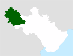
 Location of Finstria within Borland | |
| Country | Borland |
| Largest city | Werlaigh |
| Administrative capital | Syegaire |
| Founded | 1 July 1935 |
| Population (2020) | |
| • Total | 895,000 |
| Postal codes (allocated) | 60-00 to 69-99 |
| Area codes | for multiple area codes |
Finstria (/ˈfɪnstriə/, Borish: Finstrië [ˈfinstɾiə], Weranian: Finstrien [ˈfinʃtɾiən] (locally)) is a yend in northeastern Borland. Initially founded in 1930 with the formal independence of Borland from Estmere, the yend of Mark and western areas of Berghland were incorporated into Finstria as part of the administrative reform of Borland in 1970.
Alongside Burgh, Finstria is one of the two Weranian-majority yends of Borland.
