Il Dogado: Difference between revisions
| Line 85: | Line 85: | ||
== History == | == History == | ||
== Geography == | == Geography == | ||
[[File:Porto di Lido-San Nicolò.jpg|250px|thumb|left|The Povelian Lagoon. ]] | |||
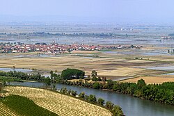
Il Dogado encompasses the entirety of the [[Povelian Lagoon]], as well as regions inland up to the Francescano Hills, directly north of [[Povelia]], a 15km wide strip running north-to-south along the western side of the Lagoon and along the east to the Peninsula of Saint Mark. Running west-to-east across the lagoon are the iconic Povelian Barrier Islands. At the centre of the federal territory lies the Povelian archipelago, where the city itself sits. The mainland areas of Il Dogado form the southern reaches of the Eugenian Plain and is predominately agricultural in nature. Il Dogado has a total area of 1,038 km² (400 square miles). | |||
[[File:RisaieVercellesi Panorama2.jpg|250px|thumb|right|The flat terrain of the mainland areas of Il Dogado.]] | |||
In recent years, Il Dogado has been in the grip of several major environmental problems, the leading issue facing the territory is the annual flooding of Povelia, which disrupts the operation of the city and has raised long-term questions over its habitability and viability as the federal capital. Another growing issue is water pollution afflicting the Povelian Lagoon. The heavy industry of the mainland has produced significant run-off and waste being dumped in the Lagoon has increased substantially in recent years. Efforts by the territorial government to confront the issue have been hampered by slow federal action and slower action by the north states, who's industrial run-off flows downstream along the Adixe River. The Delta of the Adixe sits south of the barrier islands, though smaller channels enter the western side of the lagoon. | |||
== Government and politics == | == Government and politics == | ||
=== Povelia Question === | === Povelia Question === | ||
Revision as of 10:59, 28 April 2020
Il Dogado
| |
|---|---|
| Federal District of Il Dogado | |
Mottoes:
| |
 | |
| Country | Etruria |
| Status | Federal territory within a federal republic |
| Creation | 1888 |
| Capital | Povelia |
| Government | |
| • Type | Parliamentary system subordinate to the Federal government |
| • Body | General Council |
| • President of the Federation | Francesco Carcaterra |
| • Prefect of La Dogado | Marco Antonio Cristofori |
| Population (2020) | |
| • Total | 988,882 |
| Demonym | Cislanian |
| GDP | |
| • Total | $25,216 million |
| • Per capita | $25,500 |
| Area code | +001 |
| Official languages | Vespasian Povelian |
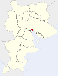
Il Dogado (Lit. The Duchy), officially known as the Federal District of Il Dogado (Vespasian: Distritto Federale del Dogado; Povelian: Distreta Federałe del Dogado), is a federal territory of Etruria encompassing the federal capital of Povelia and surrounding regions. With a population of 988,882 as of 2020, makes it the smallest administrative division in Etruria, yet with a per capita of $25,500 it is the highest in terms of income.
The territory takes its name from the Dogado of the Exalted Republic of Povelia (779-1784), owing to it sharing the exact borders of its historical predecessor. The territory was established in 1888, following the San Sepulchro Revolution, which established the Etrurian Second Republic. Povelia's declaration as the nation's capital, though meant to be temporary, became long lasting owing to its location, geography and established infrastructure.
Unlike Etruria's federal states, La Dogado has only limited self-rule and is subordinate to the federal government in most areas of governance. The government of La Dogado is based around the parliamentary system of Etruria, however, owing to its small size, the General Council of La Dogado is smaller and also holds the responsibilities of a municipal council for the city of Povelia.
History
Geography
Il Dogado encompasses the entirety of the Povelian Lagoon, as well as regions inland up to the Francescano Hills, directly north of Povelia, a 15km wide strip running north-to-south along the western side of the Lagoon and along the east to the Peninsula of Saint Mark. Running west-to-east across the lagoon are the iconic Povelian Barrier Islands. At the centre of the federal territory lies the Povelian archipelago, where the city itself sits. The mainland areas of Il Dogado form the southern reaches of the Eugenian Plain and is predominately agricultural in nature. Il Dogado has a total area of 1,038 km² (400 square miles).
In recent years, Il Dogado has been in the grip of several major environmental problems, the leading issue facing the territory is the annual flooding of Povelia, which disrupts the operation of the city and has raised long-term questions over its habitability and viability as the federal capital. Another growing issue is water pollution afflicting the Povelian Lagoon. The heavy industry of the mainland has produced significant run-off and waste being dumped in the Lagoon has increased substantially in recent years. Efforts by the territorial government to confront the issue have been hampered by slow federal action and slower action by the north states, who's industrial run-off flows downstream along the Adixe River. The Delta of the Adixe sits south of the barrier islands, though smaller channels enter the western side of the lagoon.


