Gavujuju: Difference between revisions
No edit summary |
No edit summary |
||
| Line 4: | Line 4: | ||
| native_name_lang = <!-- ISO 639-2 code e.g. "fr" for French. If more than one, use {{lang}} instead --> | | native_name_lang = <!-- ISO 639-2 code e.g. "fr" for French. If more than one, use {{lang}} instead --> | ||
| settlement_type = Megalopolis | | settlement_type = Megalopolis | ||
| image_skyline = | | image_skyline = Bangkok Night Wikimedia Commons.jpg | ||
| image_alt = | | image_alt = Bagangige, the most populous city centre in Gavujuju | ||
| image_caption = | | image_caption = [[Bagangige]], the most populous city centre in Gavujuju | ||
| image_flag = | | image_flag = | ||
| flag_alt = | | flag_alt = | ||
| Line 16: | Line 16: | ||
| nickname = | | nickname = | ||
| motto = | | motto = | ||
| image_map = | | image_map = Gavujuju.png | ||
| map_alt = | | map_alt = An expansive map of Gavujuju in Dezevau | ||
| map_caption = | | map_caption = An expansive map of Gavujuju in [[Dezevau]] | ||
| pushpin_map = | | pushpin_map = | ||
| pushpin_map_alt = | | pushpin_map_alt = | ||
| Line 26: | Line 26: | ||
| coor_pinpoint = | | coor_pinpoint = | ||
| coordinates_footnotes = | | coordinates_footnotes = | ||
| subdivision_type = | | subdivision_type = [[States of Dezevau|States]] | ||
| subdivision_name = | | subdivision_name = {{unbulleted list | ||
|[[Bagangige (state)|Bagangige]] | |||
|[[Bazadavo (state)|Bazadavo]] | |||
|[[Bedamangi (state)|Bedamangi]] | |||
|[[Dhijivodhi (state)|Dhijivodhi]] | |||
|[[Gudumi (state)|Gudumi]] | |||
|[[Naimhegebizo (state)|Naimhegebizo]] | |||
|[[Vadimhunga (state)|Vadimhunga]] | |||
|[[Vodhogou (state)|Vodhogou]] | |||
}} | |||
| subdivision_type1 = | | subdivision_type1 = | ||
| subdivision_name1 = | | subdivision_name1 = | ||
| Line 90: | Line 99: | ||
| elevation_m = | | elevation_m = | ||
| population_footnotes = | | population_footnotes = | ||
| population_as_of = | | population_as_of = 2020 | ||
| population_total = 43,592,836 | | population_total = 43,592,836 | ||
| population_density_km2 = auto | | population_density_km2 = auto | ||
Revision as of 00:16, 12 May 2020
Gavujuju | |
|---|---|
Megalopolis | |
 Bagangige, the most populous city centre in Gavujuju | |
 An expansive map of Gavujuju in Dezevau | |
| States | |
| Area | |
| • Total | 75,000 km2 (29,000 sq mi) |
| Population (2020) | |
| • Total | 43,592,836 |
| • Density | 580/km2 (1,500/sq mi) |
| Time zone | DST |
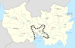
Gavujuju, or the Bay of Lights megalopolis, is a megalopolis or conurbation located in central-southern Dezevau. It has a population of around 40 million, making it by far the most populous megalopolis or urban area in Dezevau, and one of the most populous in the world. Its definition is contested, but cities and areas which may be part of Gavujuju include Bazadavo, Bagangige, Naimhegebizo, Gudumi, Vodhogou, Dhijivodhi, Bedamangi and the built-up areas around Bugunho Lake. The region includes the capital of Dezevau, and around a quarter to a third of its population and economic activity depending on the definition, while being less than a twentieth of its area. All of Gavujuju has only Ziba as a state language, bar Bazadavo which has Dezevauni Sign Language, and (when included) Bedamangi, which has Pali-Pelangi.
The region was first identified as a potential megalopolis in the 1990s, with the emergence of global urbanist studies, but the name Gavujuju (meaning "lower cities" in Ziba) gained currency with its appellation in government planning and organisational documents in the 21st century; the government of Dezevau has taken the concept of the region into account to an extent in its demographic, economic, infrastructural and cultural programmes. Some, since the identification of the megalopolis, argue that Gavujuju is in fact a conurbation, a metropolitan area or an agglomeration, being more tightly integrated today. The idea of the Doboadane megalopolis, distant in the northeast of the country and much smaller, is sometimes counterpoised with Gavujuju.
Definition
The core of the Gavujuju region is the cities of Bazadavo, Bagangige and Naimhegebizo, with over 15 million inhabitants between them alone; these are the three largest cities in Dezevau, including the capital, in an area around a hundredth of the country's size. However, Gavujuju is commonly defined as more expansive than this, with the entire state of Bazadavo, urbanities around Bugunho Lake, minor cities in the states of Bagangige and Naimhegebizo and Gudumi being most commonly also included, bringing the population to over 25 million at a few percent of the national size. Dhijivodhi and Vodhogou are also often included, with which the population rises to around 35 million; generally, it is not contended that these cities ever form a conurbation, rather only in more restricted definitions. Bedamangi is the most commonly excluded, but is increasingly accepted; it has been said that government policy seeks to integrate it with the region to help stem Pelangi regionalism and separatism, though these phenomena are in any case strongest further east of the city of Bedamangi itself, in the non-urban areas of the state of Bedamangi.
Constituents
| Constituent | State | Population |
|---|---|---|
| Bagangige | Bagangige | 6,845,014 |
| Mhaugebodhou | Bagangige | 584,331 |
| State of Bagangige miscellaneous | Bagangige | 2,134,736 |
| Bazadavo | Bazadavo | 3,905,633 |
| Diabinge | Bazadavo | 125,334 |
| Rest of state of Bazadavo | Bazadavo | 974,666 |
| Bedamangi | Bedamangi | 2,398,465 |
| State of Bedamangi miscellaneous | Bedamangi | 1,200,331 |
| Dhijivodhi | Dhijivodhi | 2,784,515 |
| State of Dhijivodhi miscellaneous | Dhijivodhi | 2,669,982 |
| Gudumi | Gudumi | 2,899,378 |
| Ngimhigobogo | Gudumi | 883,965 |
| State of Gudumi miscellaneous | Gudumi | 1,109,221 |
| Naimhegebizo | Naimhegebizo | 6,014,493 |
| Gavunhuagojuno | Naimhegebizo | 1,243,501 |
| State of Naimhegebizo miscellaneous | Naimhegebizo | 1,563,772 |
| State of Vadimhunga miscellaneous | Vadimhunga | 845,298 |
| Vodhogou | Vodhogou | 2,306,222 |
| Gonauvinau | Vodhogou | 1,115,566 |
| State of Vodhogou miscellaneous | Vodhogou | 1,988,413 |
| Total | 43,592,836 |
Natural geography
As reflected in its name, Gavujuju is primarily located on the low-lying lands around the Bay of Lights, downstream of the major river systems of Dezevau which drain towards the south. It is roughly bounded by mountains in Bedamangi to the east, highlands to the west (much of them part of the Buiganhingi Craton), and inland areas of more gently rising elevation to the north.
Its riverine geography is significant to its morphology; historically, rivers were very significant to the city-states of the Dezevauni region, not only as sources of water but as conduits for transport, whether for the purposes of migration, war or trade. Gavujuju sits at the intersection of the Bugunho and Buiganhingi river systems, whose basins contain the overwhelming majority of the Dezevauni population, economy and landmass. This intersection occurs both through canals and on the Bay of Lights; Gavujuju is coastal. It is notably proximate to the Bay of Lights reef, which is biologically significant; its runoff and pollution affect this coral reef system. Reclamation has altered the coastline in some urban areas, additionally.
The area in which Gavujuju is located is characterised by a tropical climate, which in the past was fairly uniformly rainforest, before the advent of agriculture and subsequent artificial deforestation. Biodiversity, rainfall and temperature are high. The climate does not tend to vary much, and cyclones almost never hit, owing to proximity to the equator.
Mineral resources are scarce in Gavujuju, but uplift from the collision of terranes with the Coian continent have resulted in deposits of stone, which have a long history of being quarried.
Infrastructure
Gavujuju has high speed rail connecting the largest city centres, merged commuter and interurban rail systems, and mass rapid transit which still tends to be fractured between city centres, but which is increasingly linking up. Highways also exist. Additionally, it has increasingly integrated water and sewerage systems. This section is, in fact, a work in progress.
Economy
The economy of Gavujuju is diversified and advanced, based on intensive agriculture (often using the modified geguonhi system), light, heavy and high-tech manufacturing, and a wide variety of services, including tourism, logistics, retail, health and the arts. The largest proportion of research and other quaternary sector activities also occur in Dezevau in Gavujuju. The region is wealthier and more productive than other parts of Dezevau, though the inequity is to a lesser extent than is characteristic of most capital regions of countries.
